
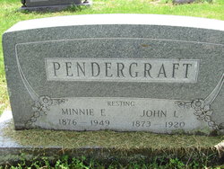
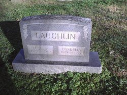
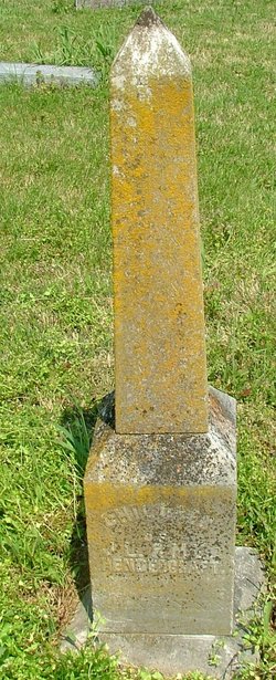
Minnie Ellen Laughlin Pendergraft
| Birth | : | 25 Oct 1876 Powell, McDonald County, Missouri, USA |
| Death | : | 19 Jul 1949 Powell, McDonald County, Missouri, USA |
| Burial | : | Sebastopol Memorial Lawn Cemetery, Sebastopol, Sonoma County, USA |
| Coordinate | : | 38.3981018, -122.8366013 |
| Inscription | : | RESTING |
| Description | : | Wife of John Pendergraft. Daughter of Tom and Ellen (Boles) Laughlin |
frequently asked questions (FAQ):
-
Where is Minnie Ellen Laughlin Pendergraft's memorial?
Minnie Ellen Laughlin Pendergraft's memorial is located at: Sebastopol Memorial Lawn Cemetery, Sebastopol, Sonoma County, USA.
-
When did Minnie Ellen Laughlin Pendergraft death?
Minnie Ellen Laughlin Pendergraft death on 19 Jul 1949 in Powell, McDonald County, Missouri, USA
-
Where are the coordinates of the Minnie Ellen Laughlin Pendergraft's memorial?
Latitude: 38.3981018
Longitude: -122.8366013
Family Members:
Parent

Spouse

Siblings

Children


Nearby Cemetories:
1. Sebastopol Memorial Lawn Cemetery
Sebastopol, Sonoma County, USA
Coordinate: 38.3981018, -122.8366013
2. Pleasant Hills Memorial Park and Mortuary
Sebastopol, Sonoma County, USA
Coordinate: 38.3792000, -122.8350983
3. Spring Hill Cemetery
Sebastopol, Sonoma County, USA
Coordinate: 38.3968010, -122.8637009
4. Gilliam Cemetery
Graton, Sonoma County, USA
Coordinate: 38.4314995, -122.8816986
5. Canfield Cemetery
Sebastopol, Sonoma County, USA
Coordinate: 38.3512430, -122.8147040
6. Steele Family Cemetery
Santa Rosa, Sonoma County, USA
Coordinate: 38.4523730, -122.8065610
7. Green Valley Cemetery
Sebastopol, Sonoma County, USA
Coordinate: 38.4424019, -122.8869019
8. Jasper O'Farrell Ranch Cemetery
Freestone, Sonoma County, USA
Coordinate: 38.3758300, -122.9090300
9. Macedonia Methodist Episcopal Church Cemetery
Sebastopol, Sonoma County, USA
Coordinate: 38.3594860, -122.7727270
10. Forestview Cemetery
Forestville, Sonoma County, USA
Coordinate: 38.4677010, -122.8834000
11. Druids Occidental Cemetery
Occidental, Sonoma County, USA
Coordinate: 38.4104996, -122.9419022
12. Bloomfield Cemetery
Bloomfield, Sonoma County, USA
Coordinate: 38.3135986, -122.8583984
13. Chapel of the Chimes Cemetery and Mausoleum
Santa Rosa, Sonoma County, USA
Coordinate: 38.4141998, -122.7137985
14. Fulton Cemetery
Fulton, Sonoma County, USA
Coordinate: 38.4888000, -122.7786026
15. Luther Burbank Memorial Home and Gardens Cemetery
Santa Rosa, Sonoma County, USA
Coordinate: 38.4355810, -122.7118050
16. Beth Ami Cemetery
Santa Rosa, Sonoma County, USA
Coordinate: 38.4590920, -122.7086070
17. Shomrei Torah Cemetery
Santa Rosa, Sonoma County, USA
Coordinate: 38.4593760, -122.7086480
18. Santa Rosa Odd Fellows Cemetery
Santa Rosa, Sonoma County, USA
Coordinate: 38.4573690, -122.7066530
19. Saint Theresa of Avila Church Cemetery
Bodega, Sonoma County, USA
Coordinate: 38.3461342, -122.9723663
20. Santa Rosa Memorial Park
Santa Rosa, Sonoma County, USA
Coordinate: 38.4597015, -122.7071991
21. Santa Rosa Rural Cemetery
Santa Rosa, Sonoma County, USA
Coordinate: 38.4557991, -122.7039032
22. County of Sonoma Cemetery
Santa Rosa, Sonoma County, USA
Coordinate: 38.4552780, -122.7027780
23. Old County Cemetery
Santa Rosa, Sonoma County, USA
Coordinate: 38.4669991, -122.7083969
24. Calvary Cemetery
Bodega, Sonoma County, USA
Coordinate: 38.3414993, -122.9749985