


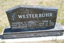
Tamme Elhers “Tom” Westerbuhr
| Birth | : | 22 Mar 1906 |
| Death | : | 27 May 1995 Kearney, Buffalo County, Nebraska, USA |
| Burial | : | St. Mary's Churchyard, Stradsett, Kings Lynn and West Norfolk Borough, England |
| Coordinate | : | 52.6178500, 0.4588500 |
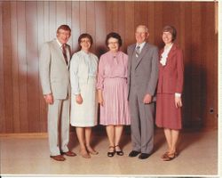
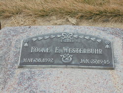
| Description | : | Tamme (Tom) Eilers Westerbuhr was born, the ninth child or twelve children, to Reverend Eillert Focken Westerbuhr and Antje (Quadhamer) Westerbuhr on March 22, 1906, on a farm southwest of Hidreth in Franklin County, Nebraska. He was baptized at the Emmanuel Lutheran Church south of Hildreth. He departed this life Saturday morning May 27, 1995, at the Good Samaritan Hospital, Kearney, where he had been a patient since May 24. His was 89 years old. He attended Rural School District #74, known as the Rosebud Country School. In early adulthood, Tom worked on the family farm with his brothers... Read More |
frequently asked questions (FAQ):
-
Where is Tamme Elhers “Tom” Westerbuhr's memorial?
Tamme Elhers “Tom” Westerbuhr's memorial is located at: St. Mary's Churchyard, Stradsett, Kings Lynn and West Norfolk Borough, England.
-
When did Tamme Elhers “Tom” Westerbuhr death?
Tamme Elhers “Tom” Westerbuhr death on 27 May 1995 in Kearney, Buffalo County, Nebraska, USA
-
Where are the coordinates of the Tamme Elhers “Tom” Westerbuhr's memorial?
Latitude: 52.6178500
Longitude: 0.4588500
Family Members:
Parent
Spouse
Siblings

Children
Flowers:


Nearby Cemetories:
1. St. Mary's Churchyard
Stradsett, Kings Lynn and West Norfolk Borough, England
Coordinate: 52.6178500, 0.4588500
2. St Martin's Churchyard
Fincham, Kings Lynn and West Norfolk Borough, England
Coordinate: 52.6296100, 0.4926900
3. St. Andrew's Churchyard
West Dereham, Kings Lynn and West Norfolk Borough, England
Coordinate: 52.5911080, 0.4599020
4. St. Margaret of Antioch Churchyard
Wereham, Kings Lynn and West Norfolk Borough, England
Coordinate: 52.5867700, 0.4799200
5. Holy Trinity Churchyard
Stow Bardolph, Kings Lynn and West Norfolk Borough, England
Coordinate: 52.6241340, 0.4041480
6. Saint Mary the Virgin Churchyard
Bexwell, Kings Lynn and West Norfolk Borough, England
Coordinate: 52.6040000, 0.4076000
7. All Saints Churchyard
Shouldham, Kings Lynn and West Norfolk Borough, England
Coordinate: 52.6515690, 0.4837640
8. St. Mary's Churchyard
Barton Bendish, Kings Lynn and West Norfolk Borough, England
Coordinate: 52.6198270, 0.5243860
9. All Saints Churchyard
Boughton, Kings Lynn and West Norfolk Borough, England
Coordinate: 52.5913020, 0.5080360
10. Saint Andrew's Churchyard
South Runcton, Kings Lynn and West Norfolk Borough, England
Coordinate: 52.6472700, 0.4128500
11. St. Andrew's Churchyard
Barton Bendish, Kings Lynn and West Norfolk Borough, England
Coordinate: 52.6219270, 0.5277620
12. Shouldham Priory
Shouldham, Kings Lynn and West Norfolk Borough, England
Coordinate: 52.6576070, 0.4836220
13. Rouse's Lane
Downham Market, Kings Lynn and West Norfolk Borough, England
Coordinate: 52.6007020, 0.3874400
14. Churchside Cemetery
Downham Market, Kings Lynn and West Norfolk Borough, England
Coordinate: 52.6027720, 0.3807240
15. King's Walk Cemetery
Downham Market, Kings Lynn and West Norfolk Borough, England
Coordinate: 52.6025160, 0.3808160
16. St. Michael's Churchyard
Ryston, Kings Lynn and West Norfolk Borough, England
Coordinate: 52.5895310, 0.3912770
17. St. Botolph's Churchyard
Tottenhill, Kings Lynn and West Norfolk Borough, England
Coordinate: 52.6706000, 0.4433000
18. St Mary Churchyard
Denver, Kings Lynn and West Norfolk Borough, England
Coordinate: 52.5886240, 0.3819980
19. Holy Trinity Churchyard
Marham, Kings Lynn and West Norfolk Borough, England
Coordinate: 52.6583800, 0.5236900
20. All Saints Churchyard
Stoke Ferry, Kings Lynn and West Norfolk Borough, England
Coordinate: 52.5702970, 0.5138070
21. St James Churchyard
Runcton Holme, Kings Lynn and West Norfolk Borough, England
Coordinate: 52.6598400, 0.3893490
22. Marham Cemetery
Marham, Kings Lynn and West Norfolk Borough, England
Coordinate: 52.6622260, 0.5287110
23. St. Peter's Churchyard
Stow Bridge, Kings Lynn and West Norfolk Borough, England
Coordinate: 52.6312500, 0.3508300
24. St Peter & St Paul's Church
Watlington, Kings Lynn and West Norfolk Borough, England
Coordinate: 52.6740960, 0.3961470