
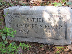

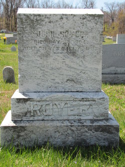
Theodore Samuel “Sade” Royer
| Birth | : | 13 Dec 1852 Cascade, Frederick County, Maryland, USA |
| Death | : | 5 May 1934 |
| Burial | : | Fleetwood Cemetery, Fleetwood, Wyre Borough, England |
| Coordinate | : | 53.9223440, -3.0370570 |
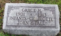
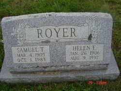
| Description | : | Children: Bina M. Royer, married Paul Robert Oller; Mary Jane Royer, married Harry Arthur "Doc" Wade; Grace Royer; Samuel Theodore Royer, married Helen Edith Flohr; John Royer, twin of Charlotte, both died in infancy; Paul Royer, Miriam Royer, married Walter Andercyk. |
frequently asked questions (FAQ):
-
Where is Theodore Samuel “Sade” Royer's memorial?
Theodore Samuel “Sade” Royer's memorial is located at: Fleetwood Cemetery, Fleetwood, Wyre Borough, England.
-
When did Theodore Samuel “Sade” Royer death?
Theodore Samuel “Sade” Royer death on 5 May 1934 in
-
Where are the coordinates of the Theodore Samuel “Sade” Royer's memorial?
Latitude: 53.9223440
Longitude: -3.0370570
Family Members:
Parent
Spouse
Siblings
Children


Flowers:


Nearby Cemetories:
1. Fleetwood Cemetery
Fleetwood, Wyre Borough, England
Coordinate: 53.9223440, -3.0370570
2. St. Peter and St. David Churchyard
Fleetwood, Wyre Borough, England
Coordinate: 53.9238123, -3.0116212
3. Preesall Cemetery
Preesall, Wyre Borough, England
Coordinate: 53.9075410, -2.9635410
4. Christ Church Thornton Churchyard
Thornton-Cleveleys, Wyre Borough, England
Coordinate: 53.8772800, -3.0221100
5. St James Churchyard
Stalmine, Wyre Borough, England
Coordinate: 53.9020510, -2.9533720
6. All Hallow's Churchyard
Bispham, Blackpool Unitary Authority, England
Coordinate: 53.8567580, -3.0372160
7. St John the Baptist's Church
Pilling, Wyre Borough, England
Coordinate: 53.9289910, -2.9114540
8. St Johns Roman Catholic Church Cemetery
Poulton-le-Fylde, Wyre Borough, England
Coordinate: 53.8520854, -2.9873511
9. Blackpool Cemetery and Crematorium
Poulton-le-Fylde, Wyre Borough, England
Coordinate: 53.8465680, -3.0196600
10. Saint Chad Churchyard
Poulton-le-Fylde, Wyre Borough, England
Coordinate: 53.8471992, -2.9925005
11. St Stephen On-the-Cliffs Churchyard
Blackpool, Blackpool Unitary Authority, England
Coordinate: 53.8407230, -3.0515610
12. St William of York Church
Pilling, Wyre Borough, England
Coordinate: 53.9235047, -2.8934617
13. Poulton-Le-Fylde Old Cemetery
Poulton-le-Fylde, Wyre Borough, England
Coordinate: 53.8458145, -2.9713324
14. Poulton New Cemetery
Poulton-le-Fylde, Wyre Borough, England
Coordinate: 53.8461240, -2.9689560
15. Blackpool Jewish Cemetery
Blackpool, Blackpool Unitary Authority, England
Coordinate: 53.8287397, -3.0311753
16. St Paul's Church & Medical Centre
Blackpool Unitary Authority, England
Coordinate: 53.8291540, -3.0533490
17. Layton Cemetery
Blackpool, Blackpool Unitary Authority, England
Coordinate: 53.8273740, -3.0328240
18. St. John’s Churchyard
Out Rawcliffe, Wyre Borough, England
Coordinate: 53.8741650, -2.8959310
19. St. Anne's Churchyard
Blackburn, Blackburn with Darwen Unitary Authority, England
Coordinate: 53.8381160, -2.9362870
20. St Anne Churchyard
Singleton, Fylde Borough, England
Coordinate: 53.8379280, -2.9359890
21. St John the Evangelist Churchyard
Blackpool, Blackpool Unitary Authority, England
Coordinate: 53.8182303, -3.0508197
22. Carlton Cemetery& Crematorium
Blackpool, Blackpool Unitary Authority, England
Coordinate: 53.8095921, -3.0364920
23. St Anne Churchyard
Great Eccleston, Wyre Borough, England
Coordinate: 53.8481413, -2.8835925
24. Saint Paul Churchyard
Great Marton, Blackpool Unitary Authority, England
Coordinate: 53.8053220, -3.0268330