
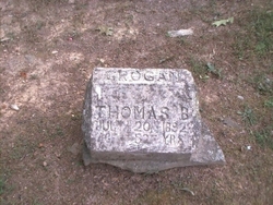
Thomas Bennet “Ben” Grogan
| Birth | : | 1841 Overton County, Tennessee, USA |
| Death | : | 20 Jul 1892 Celina, Clay County, Tennessee, USA |
| Burial | : | Skerton Cemetery, Lancaster, City of Lancaster, England |
| Coordinate | : | 54.0651430, -2.7951140 |
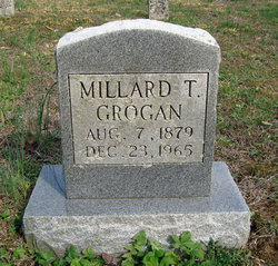
| Description | : | Thomas "Ben" Grogan was the son of Preseley Nevel Grogan & Elizabeth Odell. He married Sarah "Eunice" Watson and had 9 children: Sarah "Eunice" Watson married Thomas "Ben" Grogan. They had 9 children: Virginia, Martha, Texanna, Bernetta, Leona, Frank "Cheatum", Millard, Ida and Mary Grogan When the government began the construction of Dale Hollow Dam - his grave was one of the many diss-interned and relocated to its present location. |
frequently asked questions (FAQ):
-
Where is Thomas Bennet “Ben” Grogan's memorial?
Thomas Bennet “Ben” Grogan's memorial is located at: Skerton Cemetery, Lancaster, City of Lancaster, England.
-
When did Thomas Bennet “Ben” Grogan death?
Thomas Bennet “Ben” Grogan death on 20 Jul 1892 in Celina, Clay County, Tennessee, USA
-
Where are the coordinates of the Thomas Bennet “Ben” Grogan's memorial?
Latitude: 54.0651430
Longitude: -2.7951140
Family Members:
Spouse
Children
Flowers:


Nearby Cemetories:
1. Skerton Cemetery
Lancaster, City of Lancaster, England
Coordinate: 54.0651430, -2.7951140
2. Saint Luke's Parish Churchyard
Skerton, City of Lancaster, England
Coordinate: 54.0564700, -2.7982600
3. Lancaster and Morecambe Crematorium
Lancaster, City of Lancaster, England
Coordinate: 54.0650890, -2.8198420
4. St. John the Evangelist Churchyard
Lancaster, City of Lancaster, England
Coordinate: 54.0504000, -2.7990000
5. Lancaster Priory
Lancaster, City of Lancaster, England
Coordinate: 54.0507360, -2.8057850
6. St. Nicholas Street Chapel Churchyard
Lancaster, City of Lancaster, England
Coordinate: 54.0486900, -2.7987900
7. Lancaster Castle Cemetery
Lancaster, City of Lancaster, England
Coordinate: 54.0494330, -2.8047890
8. Friends Meeting House Burial Ground
Lancaster, City of Lancaster, England
Coordinate: 54.0482500, -2.8058025
9. Cathedral Cemetery of Lancaster
Lancaster, City of Lancaster, England
Coordinate: 54.0471170, -2.7942920
10. Lancaster Cemetery
Lancaster, City of Lancaster, England
Coordinate: 54.0504210, -2.7768760
11. Mount Street Congregational Chapel
Lancaster, City of Lancaster, England
Coordinate: 54.0468260, -2.8027430
12. St Wilfrid's Churchyard
Halton, City of Lancaster, England
Coordinate: 54.0759400, -2.7672600
13. Slyne Cemetery
Slyne, City of Lancaster, England
Coordinate: 54.0868185, -2.7969423
14. Torrisholme Cemetery
Morecambe, City of Lancaster, England
Coordinate: 54.0638980, -2.8409800
15. Christ Church United Reform Church
Bolton-le-Sands, City of Lancaster, England
Coordinate: 54.1015860, -2.7929000
16. Scotforth Cemetery
Scotforth, City of Lancaster, England
Coordinate: 54.0282250, -2.8007170
17. Holy Trinity Church Poulton-le-Sands
Morecambe, City of Lancaster, England
Coordinate: 54.0744769, -2.8569331
18. Holy Trinity Churchyard
Bolton-le-Sands, City of Lancaster, England
Coordinate: 54.1027700, -2.7911700
19. Morecambe Cemetery
Morecambe, City of Lancaster, England
Coordinate: 54.0759090, -2.8572610
20. St Peter's Churchyard
Quernmore, City of Lancaster, England
Coordinate: 54.0367200, -2.7375400
21. Nether Kellet Congregational Church
Nether Kellet, City of Lancaster, England
Coordinate: 54.1070772, -2.7587630
22. Quernmore Methodist Churchyard
Quernmore, City of Lancaster, England
Coordinate: 54.0259440, -2.7361400
23. Hale Carr Lane Cemetery
Morecambe, City of Lancaster, England
Coordinate: 54.0520500, -2.8833940
24. St. Paul Churchyard
Caton, City of Lancaster, England
Coordinate: 54.0757840, -2.7009980