
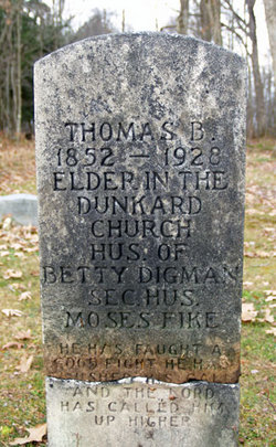
Thomas Benton Digman
| Birth | : | 13 Jul 1841 Barbour County, West Virginia, USA |
| Death | : | 6 Apr 1927 Barbour County, West Virginia, USA |
| Burial | : | Taylor-Sines Cemetery, Oakland, Garrett County, USA |
| Coordinate | : | 39.4894470, -79.4165480 |
| Inscription | : | Elder in the Dunkard Church |
| Description | : | Thomas's years for birth and death do not match his headstone inscription, however no records back up his headstone inscription information. Given that his first child was born in 1866, it is very unlikely that he was born in 1852; he would have had to marry when he was 13, and he would have been 10 years younger than his 1st wife, Judith Montgomery. The above birth and death information is per the US Civil War Soldier Records and Profiles. However, Allegheny passage : churches and families, West Marva District, Church of the Brethren, 1752-1990, states that his... Read More |
frequently asked questions (FAQ):
-
Where is Thomas Benton Digman's memorial?
Thomas Benton Digman's memorial is located at: Taylor-Sines Cemetery, Oakland, Garrett County, USA.
-
When did Thomas Benton Digman death?
Thomas Benton Digman death on 6 Apr 1927 in Barbour County, West Virginia, USA
-
Where are the coordinates of the Thomas Benton Digman's memorial?
Latitude: 39.4894470
Longitude: -79.4165480
Family Members:
Flowers:


Nearby Cemetories:
1. Taylor-Sines Cemetery
Oakland, Garrett County, USA
Coordinate: 39.4894470, -79.4165480
2. Bray Cemetery
Oakland, Garrett County, USA
Coordinate: 39.5006900, -79.3858100
3. Friend Cemetery
Oakland, Garrett County, USA
Coordinate: 39.4913500, -79.3778000
4. Herrington Cemetery
Oakland, Garrett County, USA
Coordinate: 39.4558600, -79.4474680
5. Hoyes Run Cemetery
Garrett County, USA
Coordinate: 39.5313100, -79.4110900
6. Ferndale Cemetery
Garrett County, USA
Coordinate: 39.4516983, -79.3747025
7. Rodeheaver Cemetery
Oakland, Garrett County, USA
Coordinate: 39.4804680, -79.3521300
8. John Bunyan Brant Cemetery
Oakland, Garrett County, USA
Coordinate: 39.4436800, -79.3770400
9. Lake Ford Cemetery
Garrett County, USA
Coordinate: 39.5278015, -79.4792023
10. Paradise Cemetery
Oakland, Garrett County, USA
Coordinate: 39.4712046, -79.3392075
11. DeBerry Cemetery
Oakland, Garrett County, USA
Coordinate: 39.4285000, -79.3816700
12. Garrett County Memorial Gardens
Oakland, Garrett County, USA
Coordinate: 39.4150300, -79.3932300
13. Hoye Family Cemetery - Crab Tree Bottom
McHenry, Garrett County, USA
Coordinate: 39.5642220, -79.3855000
14. Miller Cemetery
Preston County, USA
Coordinate: 39.5250015, -79.5081024
15. Oakland Cemetery
Oakland, Garrett County, USA
Coordinate: 39.4091988, -79.4028015
16. Oak Grove Cemetery
Oakland, Garrett County, USA
Coordinate: 39.4077797, -79.4069366
17. Upper Sang Run Cemetery
McHenry, Garrett County, USA
Coordinate: 39.5717810, -79.4242430
18. Oak Grove Church of the Brethren Cemetery
McHenry, Garrett County, USA
Coordinate: 39.5694400, -79.3834300
19. Cranesville Cemetery
Cranesville, Preston County, USA
Coordinate: 39.5543920, -79.4929870
20. Weber Family Cemetery
Oakland, Garrett County, USA
Coordinate: 39.4017020, -79.3959960
21. Deer Park Cemetery
Deer Park, Garrett County, USA
Coordinate: 39.4275017, -79.3261032
22. Glendale Cemetery
Oakland, Garrett County, USA
Coordinate: 39.5085983, -79.2953033
23. Kisner Cemetery
Crellin, Garrett County, USA
Coordinate: 39.4017300, -79.4674800
24. Saint Dominic Catholic Cemetery
Hoyes, Garrett County, USA
Coordinate: 39.5868300, -79.3698600