| Birth | : | 30 Jul 1893 Virginia, USA |
| Death | : | 14 Apr 1961 Polson, Lake County, Montana, USA |
| Burial | : | Galloway Cemetery, West Galloway, Kent County, Canada |
| Coordinate | : | 46.6124320, -64.8520750 |
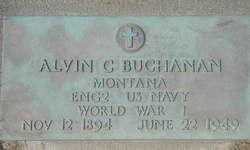
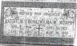
| Description | : | GRANDDAUGHTER of Miles Alexander Buchanan and Tersey Jane Mitchell Buchanan. GRANDDAUGHTER of Daniel Lewis French and Emaline Smith French. DAUGHTER of Noah Houston Buchanan and Nicatie Tennessee French Buchanan. SISTER of Daniel Melvin Buchanan, Jonas Alexander Buchanan, Alvin Curtis Buchanan, Hattie May Buchanan Crone, Cora Ann Buchanan, Rachel Florence Buchanan Wagner, Nathan Worley Buchanan, Lucy Ellen Buchanan Sturm, Garland Roosevelt Buchanan, Coosey Emaline Buchanan Stone, and James Melvin (Stone) Buchanan. WIFE of Truman Eubank. MOTHER of Orville Truman Eubank and Evelyn Marie Eubank. ____________________ I would like to thank Michelle Landroche for taking photo of memorial stone. ____________________ Card Of Thanks We wish to thank all our friends for their expressions... Read More |
frequently asked questions (FAQ):
-
Where is Urah Alice Buchanan Eubank's memorial?
Urah Alice Buchanan Eubank's memorial is located at: Galloway Cemetery, West Galloway, Kent County, Canada.
-
When did Urah Alice Buchanan Eubank death?
Urah Alice Buchanan Eubank death on 14 Apr 1961 in Polson, Lake County, Montana, USA
-
Where are the coordinates of the Urah Alice Buchanan Eubank's memorial?
Latitude: 46.6124320
Longitude: -64.8520750
Family Members:
Parent
Spouse
Siblings
Children
Flowers:
Nearby Cemetories:
1. Galloway Cemetery
West Galloway, Kent County, Canada
Coordinate: 46.6124320, -64.8520750
2. Immaculate Conception Roman Catholic Cemetery
Rexton, Kent County, Canada
Coordinate: 46.6400100, -64.8712200
3. Saint Andrew's United Church Cemetery
Rexton, Kent County, Canada
Coordinate: 46.6478700, -64.8724000
4. Methodist Point Cemetery
Rexton, Kent County, Canada
Coordinate: 46.6042300, -64.9165060
5. Chapel Point Cemetery
Richibucto, Kent County, Canada
Coordinate: 46.5966300, -64.9202300
6. Richibucto Protestant Cemetery
Richibucto, Kent County, Canada
Coordinate: 46.6730300, -64.8677700
7. Saint Louis de Gonzague
Richibucto, Kent County, Canada
Coordinate: 46.6882680, -64.8624160
8. Saint Antoine de Padoue
Richibucto, Kent County, Canada
Coordinate: 46.6568030, -64.7537160
9. Saint Anne Roman Catholic Cemetery
Sainte-Anne-de-Kent, Kent County, Canada
Coordinate: 46.5509000, -64.7738340
10. Kingdom Hall of Jehovah's Witnesses Cemetery
West Branch, Kent County, Canada
Coordinate: 46.5497546, -64.9345299
11. Saint Anne's Roman Catholic Cemetery
Big Cove, Kent County, Canada
Coordinate: 46.5854736, -64.9864107
12. West Branch Presbyterian Cemetery
West Branch, Kent County, Canada
Coordinate: 46.5410340, -64.9480820
13. St. Charles Roman Catholic Cemetery
Saint-Charles, Kent County, Canada
Coordinate: 46.6689480, -64.9729100
14. Aldouane Roman Catholic Cemetery
Aldouane, Kent County, Canada
Coordinate: 46.7098670, -64.8985700
15. Saint John's United Church Cemetery
West Branch, Kent County, Canada
Coordinate: 46.5339660, -64.9571180
16. Old MacIntosh Hill Burial Ground
Kent County, Canada
Coordinate: 46.5031240, -64.7459570
17. Saint-Louis-de-Kent Catholic Cemetery
Saint-Louis de Kent, Kent County, Canada
Coordinate: 46.7284860, -64.9799050
18. (New) Bouctouche Roman Catholic Cemetery
Bouctouche, Kent County, Canada
Coordinate: 46.5104850, -64.6827398
19. St. Stephens United Church Cemetery
Molus River, Kent County, Canada
Coordinate: 46.5763290, -65.0817130
20. St. Bartholomew's Roman Catholic Cemetery
Molus River, Kent County, Canada
Coordinate: 46.5739550, -65.0830720
21. Saint-Norbert Parish Cemetery
Saint-Norbert, Kent County, Canada
Coordinate: 46.4662200, -64.9683100
22. Saint Jean Baptiste Roman Catholic Cemetery
Bouctouche, Kent County, Canada
Coordinate: 46.4798300, -64.6968100
23. St. Lawrence Anglican Church Cemetery
Bouctouche, Kent County, Canada
Coordinate: 46.4678379, -64.7127546
24. St. Mark's Presbyterian Cemetery
Bass River, Kent County, Canada
Coordinate: 46.5424130, -65.0894630


