
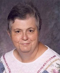
Vera Lowther Gross Carlson
| Birth | : | 30 Jul 1945 Miller, Hand County, South Dakota, USA |
| Death | : | 13 Mar 2007 Huron, Beadle County, South Dakota, USA |
| Burial | : | St Wilfrid's Churchyard, Halton, City of Lancaster, England |
| Coordinate | : | 54.0759400, -2.7672600 |
| Description | : | Vera Carlson, 61, Redfield, S.D., died Tuesday, March 13, 2007 at the Huron Regional Medical Center in Huron. Her funeral was held Saturday, March 17, at Our Savior's Lutheran Church in Redfield with the Rev. Dean Manning officiating. Burial was in Greenlawn Cemetery. Vera was born July 30, 1945 in Miller, S.D. to Vere and Daisy (Williams) Lowther. She grew up in the Miller area and graduated from Miller High School in 1963. Vera married Ted Gross July 1, 1966 and they lived in the Doland area for twenty years. She worked at West Park in Huron for several years.... Read More |
frequently asked questions (FAQ):
-
Where is Vera Lowther Gross Carlson's memorial?
Vera Lowther Gross Carlson's memorial is located at: St Wilfrid's Churchyard, Halton, City of Lancaster, England.
-
When did Vera Lowther Gross Carlson death?
Vera Lowther Gross Carlson death on 13 Mar 2007 in Huron, Beadle County, South Dakota, USA
-
Where are the coordinates of the Vera Lowther Gross Carlson's memorial?
Latitude: 54.0759400
Longitude: -2.7672600
Family Members:
Parent

Spouse
Siblings
Flowers:


Nearby Cemetories:
1. St Wilfrid's Churchyard
Halton, City of Lancaster, England
Coordinate: 54.0759400, -2.7672600
2. Skerton Cemetery
Lancaster, City of Lancaster, England
Coordinate: 54.0651430, -2.7951140
3. Slyne Cemetery
Slyne, City of Lancaster, England
Coordinate: 54.0868185, -2.7969423
4. Lancaster Cemetery
Lancaster, City of Lancaster, England
Coordinate: 54.0504210, -2.7768760
5. Saint Luke's Parish Churchyard
Skerton, City of Lancaster, England
Coordinate: 54.0564700, -2.7982600
6. Christ Church United Reform Church
Bolton-le-Sands, City of Lancaster, England
Coordinate: 54.1015860, -2.7929000
7. Holy Trinity Churchyard
Bolton-le-Sands, City of Lancaster, England
Coordinate: 54.1027700, -2.7911700
8. Nether Kellet Congregational Church
Nether Kellet, City of Lancaster, England
Coordinate: 54.1070772, -2.7587630
9. St. John the Evangelist Churchyard
Lancaster, City of Lancaster, England
Coordinate: 54.0504000, -2.7990000
10. Lancaster and Morecambe Crematorium
Lancaster, City of Lancaster, England
Coordinate: 54.0650890, -2.8198420
11. Cathedral Cemetery of Lancaster
Lancaster, City of Lancaster, England
Coordinate: 54.0471170, -2.7942920
12. St. Nicholas Street Chapel Churchyard
Lancaster, City of Lancaster, England
Coordinate: 54.0486900, -2.7987900
13. Lancaster Priory
Lancaster, City of Lancaster, England
Coordinate: 54.0507360, -2.8057850
14. Lancaster Castle Cemetery
Lancaster, City of Lancaster, England
Coordinate: 54.0494330, -2.8047890
15. Friends Meeting House Burial Ground
Lancaster, City of Lancaster, England
Coordinate: 54.0482500, -2.8058025
16. Mount Street Congregational Chapel
Lancaster, City of Lancaster, England
Coordinate: 54.0468260, -2.8027430
17. St. Paul Churchyard
Caton, City of Lancaster, England
Coordinate: 54.0757840, -2.7009980
18. St Peter's Churchyard
Quernmore, City of Lancaster, England
Coordinate: 54.0367200, -2.7375400
19. Torrisholme Cemetery
Morecambe, City of Lancaster, England
Coordinate: 54.0638980, -2.8409800
20. St Cuthbert Churchyard
Over Kellet, City of Lancaster, England
Coordinate: 54.1195480, -2.7318200
21. Carnforth Cemetery
Carnforth, City of Lancaster, England
Coordinate: 54.1245420, -2.7587820
22. Scotforth Cemetery
Scotforth, City of Lancaster, England
Coordinate: 54.0282250, -2.8007170
23. Holy Trinity Church Poulton-le-Sands
Morecambe, City of Lancaster, England
Coordinate: 54.0744769, -2.8569331
24. Morecambe Cemetery
Morecambe, City of Lancaster, England
Coordinate: 54.0759090, -2.8572610