
| Birth | : | 31 Mar 1936 Guttenberg, Clayton County, Iowa, USA |
| Death | : | 12 Jul 2021 Mankato, Blue Earth County, Minnesota, USA |
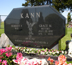
| Burial | : | Guttenberg Cemetery, Guttenberg, Clayton County, USA |
| Coordinate | : | 42.7691994, -91.1035995 |
| Description | : | Verdus Joseph Kann, 85, of Mankato, MN, passed away unexpectedly in his home on July 12, 2021. Verdus was born March 31, 1936, in Guttenberg, the son of Herbert and Ida (Heck) Kann. He attended Jefferson #6 country school until 8th grade. After school he worked on the family farm until he joined the army in 1959. He was discharged in 1965 and returned to the home farm. On June 19rd, 1972 he married Sandra Eberhard Clefisch. The couple had one son,... Read More |
frequently asked questions (FAQ):
-
Where is Verdus Joseph “Verdi” Kann's memorial?
Verdus Joseph “Verdi” Kann's memorial is located at: Guttenberg Cemetery, Guttenberg, Clayton County, USA.
-
When did Verdus Joseph “Verdi” Kann death?
Verdus Joseph “Verdi” Kann death on 12 Jul 2021 in Mankato, Blue Earth County, Minnesota, USA
-
Where are the coordinates of the Verdus Joseph “Verdi” Kann's memorial?
Latitude: 42.7691994
Longitude: -91.1035995
Family Members:
Parent
Spouse

Siblings
Flowers:


Nearby Cemetories:
1. Guttenberg Cemetery
Guttenberg, Clayton County, USA
Coordinate: 42.7691994, -91.1035995
2. Mount Olivet Cemetery
Guttenberg, Clayton County, USA
Coordinate: 42.7764840, -91.1083560
3. Saint Johns Cemetery
Jefferson Township, Clayton County, USA
Coordinate: 42.7497000, -91.1133000
4. Saint Marys Cemetery
Guttenberg, Clayton County, USA
Coordinate: 42.7691994, -91.1352997
5. Old Saint Marys Cemetery
Glen Haven, Grant County, USA
Coordinate: 42.8078100, -91.0675330
6. Bierer Cemetery
Millville, Clayton County, USA
Coordinate: 42.7230500, -91.0925166
7. Charlotte Cemetery
Glen Haven, Grant County, USA
Coordinate: 42.7933006, -91.0381012
8. Redman Cemetery
Millville, Clayton County, USA
Coordinate: 42.7166755, -91.0852901
9. Borcherding Cemetery
Jefferson Township, Clayton County, USA
Coordinate: 42.8182983, -91.1414032
10. Storck Cemetery
Guttenberg, Clayton County, USA
Coordinate: 42.7694335, -91.1834638
11. Friedlein Cemetery
Millville, Clayton County, USA
Coordinate: 42.7080994, -91.1108017
12. Lewis Cemetery
Osterdock, Clayton County, USA
Coordinate: 42.7416000, -91.1834000
13. Saint Michael Cemetery
Clayton County, USA
Coordinate: 42.8055992, -91.1802979
14. Duncan Cemetery
Glen Haven, Grant County, USA
Coordinate: 42.8325540, -91.0725940
15. Saint Paula Cemetery
Osterdock, Clayton County, USA
Coordinate: 42.7635994, -91.1992035
16. Gockel Cemetery
Glen Haven, Grant County, USA
Coordinate: 42.8224983, -91.0385971
17. Ramsey Cemetery
North Andover, Grant County, USA
Coordinate: 42.7817001, -90.9972000
18. Bethel Cemetery
Osterdock, Clayton County, USA
Coordinate: 42.7041702, -91.1688919
19. Pioneer Rock Cemetery
Ceres, Clayton County, USA
Coordinate: 42.8230591, -91.1863937
20. Goshen Cemetery
Millville, Clayton County, USA
Coordinate: 42.6905594, -91.0544434
21. Scott Cemetery
Glen Haven, Grant County, USA
Coordinate: 42.8368988, -91.0299988
22. Graham Cemetery
Millville, Clayton County, USA
Coordinate: 42.6833172, -91.1195685
23. Tangeman Family Cemetery
Garnavillo, Clayton County, USA
Coordinate: 42.8580000, -91.1420000
24. McClelland Cemetery
Garnavillo, Clayton County, USA
Coordinate: 42.8249879, -91.2084641