
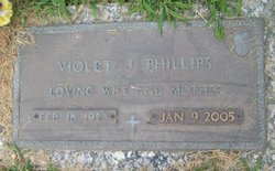
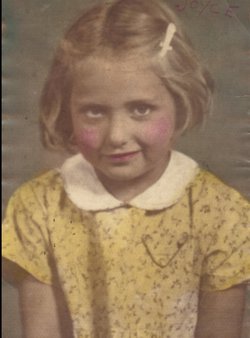
Violet Jean Stroughmatt Phillips
| Birth | : | 18 Feb 1923 Mount Carmel, Wabash County, Illinois, USA |
| Death | : | 9 Jan 2005 Muscatine, Muscatine County, Iowa, USA |
| Burial | : | Carlton Cemetery, Nottingham, Nottingham Unitary Authority, England |
| Coordinate | : | 52.9682820, -1.0900230 |
| Inscription | : | Loving Wife and Mother. |
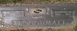
| Description | : | MUSCATINE, Iowa - Violet J. Phillips, 81, of Muscatine, died Sunday, Jan. 9, 2005, at her home. The Rev. Bruce Martin of Calvary Church will officiate the services. Burial will be in Memorial Park Cemetery in Muscatine on Tuesday, Jan. 11 at graveside services at 1:30 p.m. Memorials may be directed to Genesis Hospice in her name. Mrs. Phillips was born on Feb. 18, 1923, in Mt. Carmel, Ill., the daughter of Fred and Blanche Leet Stroughmatt. She married Ellis Phillips Jr. in Iowa City on April 16, 1949. She worked for the Muscatine School System for nine years. She... Read More |
frequently asked questions (FAQ):
-
Where is Violet Jean Stroughmatt Phillips's memorial?
Violet Jean Stroughmatt Phillips's memorial is located at: Carlton Cemetery, Nottingham, Nottingham Unitary Authority, England.
-
When did Violet Jean Stroughmatt Phillips death?
Violet Jean Stroughmatt Phillips death on 9 Jan 2005 in Muscatine, Muscatine County, Iowa, USA
-
Where are the coordinates of the Violet Jean Stroughmatt Phillips's memorial?
Latitude: 52.9682820
Longitude: -1.0900230
Family Members:
Parent

Spouse
Siblings

Flowers:


Nearby Cemetories:
1. Carlton Cemetery
Nottingham, Nottingham Unitary Authority, England
Coordinate: 52.9682820, -1.0900230
2. All Hallows Churchyard
Gedling, Gedling Borough, England
Coordinate: 52.9769400, -1.0805130
3. Gedling Cemetery
Gedling, Gedling Borough, England
Coordinate: 52.9806930, -1.0870670
4. St. Paul's Churchyard
Nottingham Unitary Authority, England
Coordinate: 52.9667590, -1.1172140
5. St. Luke's Churchyard
Stoke Bardolph, Gedling Borough, England
Coordinate: 52.9659896, -1.0404380
6. St Luke's Churchyard
Stoke Bardolph, Gedling Borough, England
Coordinate: 52.9680500, -1.0389300
7. St. Mary Rest Ground
Nottingham, Nottingham Unitary Authority, England
Coordinate: 52.9568310, -1.1406580
8. National Ice Centre
Nottingham, Nottingham Unitary Authority, England
Coordinate: 52.9527790, -1.1394460
9. St Mary's Burial Grounds
Nottingham, Nottingham Unitary Authority, England
Coordinate: 52.9527860, -1.1419160
10. St Mary Churchyard
Radcliffe-on-Trent, Rushcliffe Borough, England
Coordinate: 52.9464660, -1.0419420
11. Burton Joyce Cemetery
Burton Joyce, Gedling Borough, England
Coordinate: 52.9863100, -1.0370710
12. National Justice Museum High Pavement Nottingham
Nottingham Unitary Authority, England
Coordinate: 52.9510680, -1.1443050
13. Radcliffe-on-Trent Cemetery
Radcliffe-on-Trent, Rushcliffe Borough, England
Coordinate: 52.9459200, -1.0409700
14. St. Helen's Churchyard
Burton Joyce, Gedling Borough, England
Coordinate: 52.9866700, -1.0365400
15. St. John's Carrington Churchyard
Nottingham, Nottingham Unitary Authority, England
Coordinate: 52.9755350, -1.1506790
16. St Peters Church Yard
Nottingham, Nottingham Unitary Authority, England
Coordinate: 52.9522800, -1.1486940
17. Nottingham Church Cemetery
Nottingham, Nottingham Unitary Authority, England
Coordinate: 52.9649830, -1.1558070
18. St Nicholas Churchyard
Nottingham, Nottingham Unitary Authority, England
Coordinate: 52.9504780, -1.1509220
19. Cathedral Church of St. Barnabas
Nottingham, Nottingham Unitary Authority, England
Coordinate: 52.9546750, -1.1570460
20. Nottingham General Cemetery
Nottingham, Nottingham Unitary Authority, England
Coordinate: 52.9575370, -1.1594236
21. St. Giles's Church & Churchyard
West Bridgford, Rushcliffe Borough, England
Coordinate: 52.9316460, -1.1288450
22. General Cemetery
Nottingham, Nottingham Unitary Authority, England
Coordinate: 52.9561430, -1.1615420
23. SS Peter & Paul Churchyard
Shelford, Rushcliffe Borough, England
Coordinate: 52.9745600, -1.0161200
24. Hardy Street Jewish Cemetery
Nottingham, Nottingham Unitary Authority, England
Coordinate: 52.9619500, -1.1665900