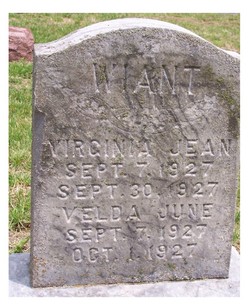
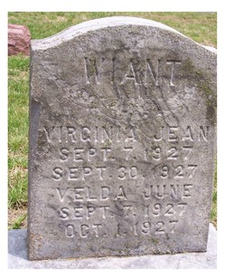
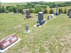
Virginia Jean Wiant
| Birth | : | 7 Sep 1927 |
| Death | : | 30 Sep 1927 |
| Burial | : | Holy Trinity Churchyard, Burnley, Burnley Borough, England |
| Coordinate | : | 53.7898290, -2.2574200 |
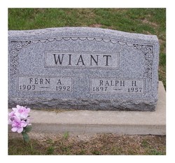
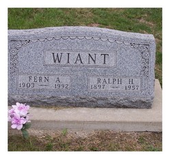
| Description | : | Plot #05-12 Twin daughter of Ralph Harlan Wiant and Fern Annis Reynolds Wiant. She died age 23 days and is buried beside her parents and twin sister who died the following day. Obituary: September 7th [1927], Virginia Gene and Velda June Wiant came hand in hand into the home of Mr. and Mrs. Ralph H. Wiant[Fern Reynolds], as the heritage of the Lord, to gladden their lives and to enlarge the borders of their family circle. But they tarried but a few days, and then departed again to be with him who gave them their being. September 30, Virginia Gene departed this life, and... Read More |
frequently asked questions (FAQ):
-
Where is Virginia Jean Wiant's memorial?
Virginia Jean Wiant's memorial is located at: Holy Trinity Churchyard, Burnley, Burnley Borough, England.
-
When did Virginia Jean Wiant death?
Virginia Jean Wiant death on 30 Sep 1927 in
-
Where are the coordinates of the Virginia Jean Wiant's memorial?
Latitude: 53.7898290
Longitude: -2.2574200
Family Members:
Parent
Siblings
Flowers:
Nearby Cemetories:
1. Holy Trinity Churchyard
Burnley, Burnley Borough, England
Coordinate: 53.7898290, -2.2574200
2. St. James' Churchyard
Burnley, Burnley Borough, England
Coordinate: 53.7905590, -2.2458280
3. St. Peter's Churchyard
Burnley, Burnley Borough, England
Coordinate: 53.7924450, -2.2394890
4. Ebenezer Baptist Chapel Chapelyard
Burnley, Burnley Borough, England
Coordinate: 53.7975120, -2.2397260
5. Burnley Cemetery
Burnley, Burnley Borough, England
Coordinate: 53.7821730, -2.2795070
6. Burnley Crematorium
Burnley, Burnley Borough, England
Coordinate: 53.7821730, -2.2795070
7. All Saints Churchyard
Habergham Eaves, Burnley Borough, England
Coordinate: 53.7971060, -2.2913770
8. St. John's Cemetery
Padiham, Burnley Borough, England
Coordinate: 53.7948720, -2.3145290
9. St Margaret Churchyard
Hapton, Burnley Borough, England
Coordinate: 53.7802400, -2.3169230
10. St. Leonard's Churchyard
Padiham, Burnley Borough, England
Coordinate: 53.8022600, -2.3164300
11. Wesleyan Methodist Chapel Chapelyard
Padiham, Burnley Borough, England
Coordinate: 53.8018980, -2.3181730
12. St. James' Churchyard
Briercliffe, Burnley Borough, England
Coordinate: 53.8107700, -2.2031800
13. St Leonard Churchyard Extension
Padiham, Burnley Borough, England
Coordinate: 53.7991800, -2.3222000
14. St John Churchyard
Higham, Pendle Borough, England
Coordinate: 53.8251420, -2.2898120
15. St. John the Evangelist Churchyard
Worsthorne, Burnley Borough, England
Coordinate: 53.7877640, -2.1887420
16. Marsden Friends Burial Ground
Marsden, Metropolitan Borough of Kirklees, England
Coordinate: 53.8241910, -2.2197410
17. St. Anne Churchyard
Fence, Pendle Borough, England
Coordinate: 53.8304372, -2.2679552
18. Haggate Baptist Church Burial Ground
Burnley Borough, England
Coordinate: 53.8145048, -2.1960725
19. Wheatley Lane Methodist Churchyard
Fence, Pendle Borough, England
Coordinate: 53.8341457, -2.2596202
20. St. Paul's Churchyard
Nelson, Pendle Borough, England
Coordinate: 53.8289250, -2.2157520
21. Providence Free United Methodist Graveyard
Crawshawbooth, Rossendale Borough, England
Coordinate: 53.7442070, -2.2825700
22. Hill Lane Baptist Church Churchyard
Briercliffe, Burnley Borough, England
Coordinate: 53.8161467, -2.1875368
23. Wheatley Lane Inghamite Church Churchyard
Wheatley Lane, Pendle Borough, England
Coordinate: 53.8412800, -2.2457100
24. St James Church
Altham, Hyndburn Borough, England
Coordinate: 53.7928940, -2.3465250

