
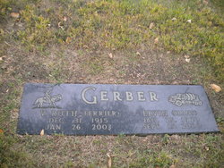
Virginia Ruth Ferrier Gerber
| Birth | : | 31 Dec 1915 |
| Death | : | 26 Jan 2003 |
| Burial | : | Greenwood Memorial Park, Centralia, Lewis County, USA |
| Coordinate | : | 46.7372017, -122.9824982 |
frequently asked questions (FAQ):
-
Where is Virginia Ruth Ferrier Gerber's memorial?
Virginia Ruth Ferrier Gerber's memorial is located at: Greenwood Memorial Park, Centralia, Lewis County, USA.
-
When did Virginia Ruth Ferrier Gerber death?
Virginia Ruth Ferrier Gerber death on 26 Jan 2003 in
-
Where are the coordinates of the Virginia Ruth Ferrier Gerber's memorial?
Latitude: 46.7372017
Longitude: -122.9824982
Family Members:
Parent

Spouse

Siblings

Flowers:


Nearby Cemetories:
1. Greenwood Memorial Park
Centralia, Lewis County, USA
Coordinate: 46.7372017, -122.9824982
2. Mountain View Cemetery
Centralia, Lewis County, USA
Coordinate: 46.7289009, -122.9843979
3. Pioneer Cemetery
Centralia, Lewis County, USA
Coordinate: 46.7290300, -122.9898100
4. Washington Lawn Cemetery
Centralia, Lewis County, USA
Coordinate: 46.7209320, -122.9606040
5. Cogdil Family Cemetery
Thurston County, USA
Coordinate: 46.7747010, -122.8826590
6. Grand Mound Cemetery
Rochester, Thurston County, USA
Coordinate: 46.8213997, -123.0199966
7. Greenwood Cemetery
Chehalis, Lewis County, USA
Coordinate: 46.6511002, -122.9389038
8. Claquato Cemetery
Chehalis, Lewis County, USA
Coordinate: 46.6469002, -123.0216980
9. Newaukum Hill Cemetery
Lewis County, USA
Coordinate: 46.6338980, -122.9768320
10. Fern Hill Cemetery
Chehalis, Lewis County, USA
Coordinate: 46.6366710, -122.9418560
11. Lincoln Creek Cemetery
Galvin, Lewis County, USA
Coordinate: 46.7604700, -123.1446600
12. Forest Grove Cemetery
Tenino, Thurston County, USA
Coordinate: 46.8254580, -122.8497110
13. Chehalis Tribal Cemetery
Thurston County, USA
Coordinate: 46.8068570, -123.1602260
14. Secena Cemetery
Oakville, Grays Harbor County, USA
Coordinate: 46.8061600, -123.1611900
15. Finn Hill Cemetery
Lewis County, USA
Coordinate: 46.7564011, -123.1919022
16. Mima Prairie Pioneer Cemetery
Mima, Thurston County, USA
Coordinate: 46.8724403, -123.0611649
17. Pleasant Hill Cemetery
Bunker, Lewis County, USA
Coordinate: 46.6088840, -123.0863790
18. Thurston County Poor Farm Cemetery
Littlerock, Thurston County, USA
Coordinate: 46.8861790, -123.0225100
19. Napavine Cemetery
Napavine, Lewis County, USA
Coordinate: 46.5817000, -122.9039000
20. Deskins Family Cemetery
Chehalis, Lewis County, USA
Coordinate: 46.6878000, -122.7530000
21. Benn Cemetery
Oakville, Grays Harbor County, USA
Coordinate: 46.8303540, -123.2239950
22. Oakville Pioneer Cemetery
Oakville, Grays Harbor County, USA
Coordinate: 46.8318939, -123.2229996
23. Oakville Final Rest Memorial Cemetery
Oakville, Grays Harbor County, USA
Coordinate: 46.8323060, -123.2240030
24. Dryad Cemetery
Dryad, Lewis County, USA
Coordinate: 46.6467667, -123.2665329