
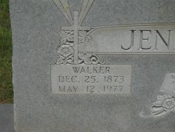
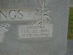
Walker Jennings
| Birth | : | 25 Dec 1873 |
| Death | : | 12 May 1977 |
| Burial | : | St Margaret Churchyard, Wetton, Staffordshire Moorlands District, England |
| Coordinate | : | 53.0955990, -1.8392170 |
frequently asked questions (FAQ):
-
Where is Walker Jennings's memorial?
Walker Jennings's memorial is located at: St Margaret Churchyard, Wetton, Staffordshire Moorlands District, England.
-
When did Walker Jennings death?
Walker Jennings death on 12 May 1977 in
-
Where are the coordinates of the Walker Jennings's memorial?
Latitude: 53.0955990
Longitude: -1.8392170
Family Members:
Parent
Spouse
Siblings
Children
Flowers:


Nearby Cemetories:
1. St Margaret Churchyard
Wetton, Staffordshire Moorlands District, England
Coordinate: 53.0955990, -1.8392170
2. St. Peter's Churchyard
Alstonefield, Staffordshire Moorlands District, England
Coordinate: 53.0951350, -1.8031540
3. All Saints Churchyard
Grindon, Staffordshire Moorlands District, England
Coordinate: 53.0879220, -1.8738510
4. St. Bartholomew's Churchyard
Butterton, Staffordshire Moorlands District, England
Coordinate: 53.1062600, -1.8814800
5. St. Lawrence Churchyard
Warslow, Staffordshire Moorlands District, England
Coordinate: 53.1248380, -1.8723470
6. St. James and St. Bartholomew Churchyard
Waterfall, Staffordshire Moorlands District, England
Coordinate: 53.0620350, -1.8791780
7. St Mary's Churchyard
Calton, Staffordshire Moorlands District, England
Coordinate: 53.0489970, -1.8472480
8. Holy Cross Churchyard
Ilam, Staffordshire Moorlands District, England
Coordinate: 53.0533440, -1.8034640
9. St Giles Churchyard
Hartington, Derbyshire Dales District, England
Coordinate: 53.1413120, -1.8075970
10. St. Luke Churchyard
Onecote, Staffordshire Moorlands District, England
Coordinate: 53.0935720, -1.9289360
11. St. Thomas Churchyard
Biggin-by-Hartington, Derbyshire Dales District, England
Coordinate: 53.1311080, -1.7703070
12. St. Luke's Churchyard
Sheen, High Peak Borough, England
Coordinate: 53.1504980, -1.8321300
13. St Mary and St Laurence Churchyard
Cauldon, Staffordshire Moorlands District, England
Coordinate: 53.0423040, -1.8845550
14. Saint Bartholomew Churchyard
Blore, Staffordshire Moorlands District, England
Coordinate: 53.0411100, -1.7963100
15. St. Bartholomew's Churchyard
Blore, Derbyshire Dales District, England
Coordinate: 53.0408190, -1.7967020
16. St. Leonard's Churchyard
Thorpe, Derbyshire Dales District, England
Coordinate: 53.0485290, -1.7682900
17. St. Edmund King and Martyr Churchyard
Fenny Bentley, Derbyshire Dales District, England
Coordinate: 53.0486820, -1.7411430
18. All Saints Church
Okeover, East Staffordshire Borough, England
Coordinate: 53.0302050, -1.7650989
19. Mapleton, St Mary
Ashbourne, Derbyshire Dales District, England
Coordinate: 53.0294190, -1.7544910
20. St. Mary's Churchyard
Mappleton, Derbyshire Dales District, England
Coordinate: 53.0294920, -1.7542220
21. St. Mary's Churchyard
Stanton, East Staffordshire Borough, England
Coordinate: 53.0109590, -1.8136560
22. St. Mark the Evangelist Churchyard
Foxt, Staffordshire Moorlands District, England
Coordinate: 53.0362440, -1.9473820
23. St. Bartholomew Churchyard
Longnor, Staffordshire Moorlands District, England
Coordinate: 53.1818800, -1.8686700
24. Cotton Cemetery
Cotton, Staffordshire Moorlands District, England
Coordinate: 53.0188110, -1.9113960