

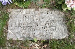
Walter Kay Carter
| Birth | : | 1928 |
| Death | : | 20 Jun 1928 Chewelah, Stevens County, Washington, USA |
| Burial | : | Pleasantville Cemetery, Alum Bank, Bedford County, USA |
| Coordinate | : | 40.1836400, -78.6133400 |
| Plot | : | SE Section |
| Description | : | Washington State Digital Archives Online Records DEATH: Walter Kay Carter death date: 20 Jun 1928 death place: Chewelah, Stevens, Washington gender: Male age at death: 8 days estimated birth year: 1928 father's name: Waller Benj. Carter mother's name: Evelyn Melior |
frequently asked questions (FAQ):
-
Where is Walter Kay Carter's memorial?
Walter Kay Carter's memorial is located at: Pleasantville Cemetery, Alum Bank, Bedford County, USA.
-
When did Walter Kay Carter death?
Walter Kay Carter death on 20 Jun 1928 in Chewelah, Stevens County, Washington, USA
-
Where are the coordinates of the Walter Kay Carter's memorial?
Latitude: 40.1836400
Longitude: -78.6133400
Family Members:
Parent

Flowers:


Nearby Cemetories:
1. Pleasantville Cemetery
Alum Bank, Bedford County, USA
Coordinate: 40.1836400, -78.6133400
2. Thomas Callihan Family Cemetery
Alum Bank, Bedford County, USA
Coordinate: 40.1835940, -78.6327630
3. Hoover Cemetery
Alum Bank, Bedford County, USA
Coordinate: 40.1853910, -78.5921790
4. Horn United Methodist Church Cemetery
Alum Bank, Bedford County, USA
Coordinate: 40.1767000, -78.5838000
5. Mock Church Cemetery
Alum Bank, Bedford County, USA
Coordinate: 40.1662407, -78.6400223
6. William Clark Sr. Cemetery
Alum Bank, Bedford County, USA
Coordinate: 40.1682400, -78.5840400
7. Mount Union Cemetery
Lovely, Bedford County, USA
Coordinate: 40.2247086, -78.6118469
8. McDonald Farm Cemetery
Bedford County, USA
Coordinate: 40.2151330, -78.5673170
9. Stone Church Cemetery
Fishertown, Bedford County, USA
Coordinate: 40.1337000, -78.5939000
10. Fishertown Lutheran Cemetery
Fishertown, Bedford County, USA
Coordinate: 40.1255500, -78.5861900
11. Fishertown Brethren Cemetery
Fishertown, Bedford County, USA
Coordinate: 40.1227300, -78.5880220
12. Fishertown Cemetery
Fishertown, Bedford County, USA
Coordinate: 40.1197357, -78.5878830
13. Mount Carmel Cemetery
Ogletown, Somerset County, USA
Coordinate: 40.2020000, -78.7037000
14. Imler Saint Paul Brethren Cemetery
Imler, Bedford County, USA
Coordinate: 40.2059937, -78.5238647
15. Old Union Cemetery
Osterburg, Bedford County, USA
Coordinate: 40.1677080, -78.5183640
16. Imler Valley Cemetery
Imler, Bedford County, USA
Coordinate: 40.2105713, -78.5224533
17. New Paris Community Cemetery
New Paris, Bedford County, USA
Coordinate: 40.1117900, -78.6404900
18. Cuppett Family Cemetery
New Paris, Bedford County, USA
Coordinate: 40.1114578, -78.6401596
19. Trinity Reformed Church Cemetery
Osterburg, Bedford County, USA
Coordinate: 40.1674309, -78.5170975
20. Ogletown Brethren Cemetery
Ogletown, Somerset County, USA
Coordinate: 40.2038000, -78.7090000
21. Osterburg Community Cemetery
Osterburg, Bedford County, USA
Coordinate: 40.1666700, -78.5154800
22. Lutheran Cemetery at Osterburg
Osterburg, Bedford County, USA
Coordinate: 40.1665600, -78.5136500
23. Mount Zion Cemetery
Pavia, Bedford County, USA
Coordinate: 40.2613525, -78.5844879
24. Beaver Lane Cemetery
Cessna, Bedford County, USA
Coordinate: 40.1085106, -78.5497407