
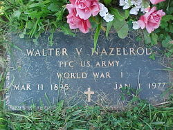
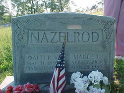
Walter Vade “Buck” Nazelrod
| Birth | : | 11 Mar 1895 Peru, Hardy County, West Virginia, USA |
| Death | : | 31 Jan 1977 Cumberland, Allegany County, Maryland, USA |
| Burial | : | Wheatley Lane Inghamite Church Churchyard, Wheatley Lane, Pendle Borough, England |
| Coordinate | : | 53.8412800, -2.2457100 |
| Description | : | Walter Vade Nazelrod was the son of John David Nazelrod and Kiziah Catherine Cleaver. He was the husband of Maude Lauretta Stallings. They share a stone. Cumberland Evening News, Cumberland, MD: February 1, 1977 WALTER NAZELROD Walter Vade Nazelrod, 81, of RD 3, Valley Road, died last night in the Cumberland Nursing Home. Born in Lilam, W.Va., he was a son of the late John David and Kiviah (Cleave) Nazelrod. Mr. Nazelrod was a retired construction worker and a veteran of World War I. Surviving are his widow, Maude (Stallings) Nazelrod; seven sons, Clyde, Homer,... Read More |
frequently asked questions (FAQ):
-
Where is Walter Vade “Buck” Nazelrod's memorial?
Walter Vade “Buck” Nazelrod's memorial is located at: Wheatley Lane Inghamite Church Churchyard, Wheatley Lane, Pendle Borough, England.
-
When did Walter Vade “Buck” Nazelrod death?
Walter Vade “Buck” Nazelrod death on 31 Jan 1977 in Cumberland, Allegany County, Maryland, USA
-
Where are the coordinates of the Walter Vade “Buck” Nazelrod's memorial?
Latitude: 53.8412800
Longitude: -2.2457100
Family Members:
Parent
Spouse

Siblings
Children

Flowers:


Nearby Cemetories:
1. Wheatley Lane Inghamite Church Churchyard
Wheatley Lane, Pendle Borough, England
Coordinate: 53.8412800, -2.2457100
2. All Souls Cemetery
Barrowford, Pendle Borough, England
Coordinate: 53.8462900, -2.2355600
3. Wheatley Lane Methodist Churchyard
Fence, Pendle Borough, England
Coordinate: 53.8341457, -2.2596202
4. St. Anne Churchyard
Fence, Pendle Borough, England
Coordinate: 53.8304372, -2.2679552
5. St. Mary's Churchyard
Newchurch in Pendle, Pendle Borough, England
Coordinate: 53.8504181, -2.2706807
6. St. Thomas Churchyard
Barrowford, Pendle Borough, England
Coordinate: 53.8513900, -2.2196600
7. St. Paul's Churchyard
Nelson, Pendle Borough, England
Coordinate: 53.8289250, -2.2157520
8. Barrowford Cemetery
Nelson, Pendle Borough, England
Coordinate: 53.8521100, -2.2130300
9. Marsden Friends Burial Ground
Marsden, Metropolitan Borough of Kirklees, England
Coordinate: 53.8241910, -2.2197410
10. Nelson Cemetery
Nelson, Pendle Borough, England
Coordinate: 53.8420330, -2.1972230
11. St. John the Evangelist Churchyard
Nelson, Pendle Borough, England
Coordinate: 53.8367000, -2.1977200
12. St John Churchyard
Higham, Pendle Borough, England
Coordinate: 53.8251420, -2.2898120
13. St. James' Churchyard
Briercliffe, Burnley Borough, England
Coordinate: 53.8107700, -2.2031800
14. Haggate Baptist Church Burial Ground
Burnley Borough, England
Coordinate: 53.8145048, -2.1960725
15. Hill Lane Baptist Church Churchyard
Briercliffe, Burnley Borough, England
Coordinate: 53.8161467, -2.1875368
16. Ebenezer Baptist Chapel Chapelyard
Burnley, Burnley Borough, England
Coordinate: 53.7975120, -2.2397260
17. St. Bartholomew Churchyard
Colne, Pendle Borough, England
Coordinate: 53.8570600, -2.1700470
18. West Street Inghamite Chapel Chapelyard
Colne, Pendle Borough, England
Coordinate: 53.8555930, -2.1672140
19. St. Peter's Churchyard
Burnley, Burnley Borough, England
Coordinate: 53.7924450, -2.2394890
20. John Ecroyd's Orchard
Lancaster, City of Lancaster, England
Coordinate: 53.8201990, -2.1697920
21. Twiston Quaker Burial Ground
Clitheroe, Ribble Valley Borough, England
Coordinate: 53.8854210, -2.2838840
22. St. James' Churchyard
Burnley, Burnley Borough, England
Coordinate: 53.7905590, -2.2458280
23. All Saints Churchyard
Habergham Eaves, Burnley Borough, England
Coordinate: 53.7971060, -2.2913770
24. Holy Trinity Churchyard
Burnley, Burnley Borough, England
Coordinate: 53.7898290, -2.2574200