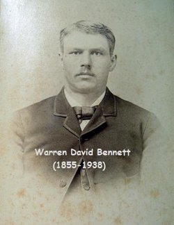
Warren David Bennett
| Birth | : | 22 Oct 1855 Pulaski, Oswego County, New York, USA |
| Death | : | 25 Mar 1938 Arcadia, Valley County, Nebraska, USA |
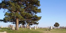
| Burial | : | Valley Memorial Park, Novato, Marin County, USA |
| Coordinate | : | 38.1204300, -122.5436300 |
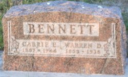
| Inscription | : | BENNETT Warren D. 1855 - 1938 |
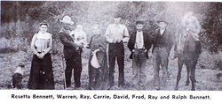
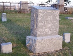
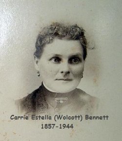
| Description | : | From the book "Arcadia's Laughter and Tears 1885 to 1978" Bennett, Warren and Carrie (Wolcott) Warren David Bennett, son of David Bennett and Rosetta Bennett, was born at Pulaski, Oswego county, New York, October 22, 1855. Mr. Bennett grew to manhood in Pulaski. On October 20, 1875 he was united in marriage to Miss Carrie Estelle Wolcott. They left Pulaski in the fall of 1877 and came to Douglas Grove near Comstock. In the spring of 1878 they homesteaded on a farm in Valley county northwest of Arcadia, where they resided until March 1st, 1906, when... Read More |
frequently asked questions (FAQ):
-
Where is Warren David Bennett's memorial?
Warren David Bennett's memorial is located at: Valley Memorial Park, Novato, Marin County, USA.
-
When did Warren David Bennett death?
Warren David Bennett death on 25 Mar 1938 in Arcadia, Valley County, Nebraska, USA
-
Where are the coordinates of the Warren David Bennett's memorial?
Latitude: 38.1204300
Longitude: -122.5436300
Family Members:
Parent
Spouse
Siblings
Children
Flowers:
Nearby Cemetories:
1. Valley Memorial Park
Novato, Marin County, USA
Coordinate: 38.1204300, -122.5436300
2. Pioneer Memorial Cemetery
Novato, Marin County, USA
Coordinate: 38.1132532, -122.5902599
3. Saint Vincents Orphanage Cemetery
San Rafael, Marin County, USA
Coordinate: 38.0355800, -122.5334550
4. Marin County Farm Cemetery
Marin County, USA
Coordinate: 38.0285500, -122.5652530
5. Mount Olivet Catholic Cemetery
San Rafael, Marin County, USA
Coordinate: 38.0024986, -122.5397034
6. Mount Tamalpais Cemetery
San Rafael, Marin County, USA
Coordinate: 37.9861984, -122.5544891
7. General Vallejo Ranch Cemetery
Sonoma, Sonoma County, USA
Coordinate: 38.2554500, -122.5845200
8. Oak Hill Cemetery
Petaluma, Sonoma County, USA
Coordinate: 38.2365130, -122.6509010
9. Mission San Rafael Arcangel Cemetery
San Rafael, Marin County, USA
Coordinate: 37.9744330, -122.5280570
10. Calvary Catholic Cemetery
Petaluma, Sonoma County, USA
Coordinate: 38.2449000, -122.6493400
11. B'nai Israel Cemetery
Petaluma, Sonoma County, USA
Coordinate: 38.2454700, -122.6490000
12. First Presbyterian Church Memorial Garden
San Anselmo, Marin County, USA
Coordinate: 37.9703310, -122.5667860
13. Cypress Hill Memorial Park
Petaluma, Sonoma County, USA
Coordinate: 38.2472000, -122.6505966
14. My Pets Cemetery
Petaluma, Sonoma County, USA
Coordinate: 38.2472000, -122.6506000
15. Montgomery Memorial Chapel Crypt
San Anselmo, Marin County, USA
Coordinate: 37.9687940, -122.5638630
16. Taylor Cemetery
Lagunitas, Marin County, USA
Coordinate: 38.0272580, -122.7346590
17. Faith Lutheran Church Memorial Garden
Sonoma, Sonoma County, USA
Coordinate: 38.2932380, -122.4880690
18. Valley Cemetery
Sonoma, Sonoma County, USA
Coordinate: 38.2832985, -122.4496994
19. San Quentin Prison Cemetery
San Rafael, Marin County, USA
Coordinate: 37.9436480, -122.4883760
20. Mission San Francisco Solano Cemetery
Sonoma, Sonoma County, USA
Coordinate: 38.2937164, -122.4561844
21. Trinity Episcopal Church Columbarium
Sonoma, Sonoma County, USA
Coordinate: 38.2930390, -122.4521650
22. Saint Francis Solano Cemetery
Sonoma, Sonoma County, USA
Coordinate: 38.2915993, -122.4459991
23. Sonoma Veterans Cemetery
Sonoma, Sonoma County, USA
Coordinate: 38.2992790, -122.4566390
24. Mountain Cemetery
Sonoma, Sonoma County, USA
Coordinate: 38.3008003, -122.4535980

