

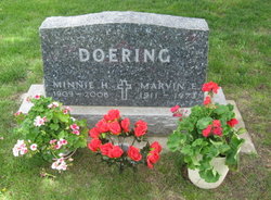
Wilhelmine Helene “Minnie” Mammen Doering
| Birth | : | 19 Jul 1909 Plymouth County, Iowa, USA |
| Death | : | 26 Mar 2006 Le Mars, Plymouth County, Iowa, USA |
| Burial | : | Holy Trinity Churchyard, Burnley, Burnley Borough, England |
| Coordinate | : | 53.7898290, -2.2574200 |
| Plot | : | Lot 14 |
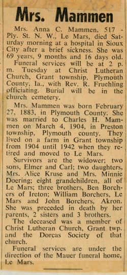
| Description | : | Minnie H. Doering Tuesday, March 28, 2006 Minnie H. Doering, 96, of Le Mars, died Sunday, March 26, 2006, at the Good Samaritan Village in Le Mars. Wilhelmine Helene Doering was born July 19, 1909, on the family farm near Le Mars, the daughter of Carl Herman "Charley" and Anna Catharina (Borchers) Mammen. She attended country school at Grant Township #9. Following her primary education, Minnie assisted her family with farming. She continued her education at Western Union College (Westmar College) in Le Mars with an emphasis on secretarial work. On Jan. 20, 1935, Minnie and... Read More |
frequently asked questions (FAQ):
-
Where is Wilhelmine Helene “Minnie” Mammen Doering's memorial?
Wilhelmine Helene “Minnie” Mammen Doering's memorial is located at: Holy Trinity Churchyard, Burnley, Burnley Borough, England.
-
When did Wilhelmine Helene “Minnie” Mammen Doering death?
Wilhelmine Helene “Minnie” Mammen Doering death on 26 Mar 2006 in Le Mars, Plymouth County, Iowa, USA
-
Where are the coordinates of the Wilhelmine Helene “Minnie” Mammen Doering's memorial?
Latitude: 53.7898290
Longitude: -2.2574200
Family Members:
Parent
Spouse
Siblings

Flowers:


Nearby Cemetories:
1. Holy Trinity Churchyard
Burnley, Burnley Borough, England
Coordinate: 53.7898290, -2.2574200
2. St. James' Churchyard
Burnley, Burnley Borough, England
Coordinate: 53.7905590, -2.2458280
3. St. Peter's Churchyard
Burnley, Burnley Borough, England
Coordinate: 53.7924450, -2.2394890
4. Ebenezer Baptist Chapel Chapelyard
Burnley, Burnley Borough, England
Coordinate: 53.7975120, -2.2397260
5. Burnley Cemetery
Burnley, Burnley Borough, England
Coordinate: 53.7821730, -2.2795070
6. Burnley Crematorium
Burnley, Burnley Borough, England
Coordinate: 53.7821730, -2.2795070
7. All Saints Churchyard
Habergham Eaves, Burnley Borough, England
Coordinate: 53.7971060, -2.2913770
8. St. John's Cemetery
Padiham, Burnley Borough, England
Coordinate: 53.7948720, -2.3145290
9. St Margaret Churchyard
Hapton, Burnley Borough, England
Coordinate: 53.7802400, -2.3169230
10. St. Leonard's Churchyard
Padiham, Burnley Borough, England
Coordinate: 53.8022600, -2.3164300
11. Wesleyan Methodist Chapel Chapelyard
Padiham, Burnley Borough, England
Coordinate: 53.8018980, -2.3181730
12. St. James' Churchyard
Briercliffe, Burnley Borough, England
Coordinate: 53.8107700, -2.2031800
13. St Leonard Churchyard Extension
Padiham, Burnley Borough, England
Coordinate: 53.7991800, -2.3222000
14. St John Churchyard
Higham, Pendle Borough, England
Coordinate: 53.8251420, -2.2898120
15. St. John the Evangelist Churchyard
Worsthorne, Burnley Borough, England
Coordinate: 53.7877640, -2.1887420
16. Marsden Friends Burial Ground
Marsden, Metropolitan Borough of Kirklees, England
Coordinate: 53.8241910, -2.2197410
17. St. Anne Churchyard
Fence, Pendle Borough, England
Coordinate: 53.8304372, -2.2679552
18. Haggate Baptist Church Burial Ground
Burnley Borough, England
Coordinate: 53.8145048, -2.1960725
19. Wheatley Lane Methodist Churchyard
Fence, Pendle Borough, England
Coordinate: 53.8341457, -2.2596202
20. St. Paul's Churchyard
Nelson, Pendle Borough, England
Coordinate: 53.8289250, -2.2157520
21. Providence Free United Methodist Graveyard
Crawshawbooth, Rossendale Borough, England
Coordinate: 53.7442070, -2.2825700
22. Hill Lane Baptist Church Churchyard
Briercliffe, Burnley Borough, England
Coordinate: 53.8161467, -2.1875368
23. Wheatley Lane Inghamite Church Churchyard
Wheatley Lane, Pendle Borough, England
Coordinate: 53.8412800, -2.2457100
24. St James Church
Altham, Hyndburn Borough, England
Coordinate: 53.7928940, -2.3465250