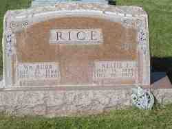
William Burr Rice
| Birth | : | 23 Dec 1894 Toledo, Lucas County, Ohio, USA |
| Death | : | 15 Oct 1968 Lexington, Dawson County, Nebraska, USA |
| Burial | : | Sebastopol Memorial Lawn Cemetery, Sebastopol, Sonoma County, USA |
| Coordinate | : | 38.3981018, -122.8366013 |
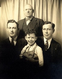
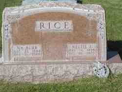
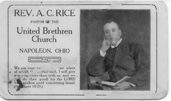
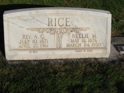
| Description | : | This is my Paternal Grandfather. Oldest known child of Rev. Artemus Charles Rice and Nellie May Harned Rice. He was married to Nettie Eliza Kern in 1915 at Napoleon, Ohio. They were the parents of William Artemus Rice, 1916; Wilnetta Arlene Rice Pickard, 1917; and Ted Alden Rice, Sr., 1928. Top person in the photo is Rev. Artemus Charles Rice, on the right is his son William Burr Rice, on the left is William Artemus Rice and the boy is Ted Alden Rice, Sr., both sons of William Burr Rice. Taken in Nebraska, circa 1933. |
frequently asked questions (FAQ):
-
Where is William Burr Rice's memorial?
William Burr Rice's memorial is located at: Sebastopol Memorial Lawn Cemetery, Sebastopol, Sonoma County, USA.
-
When did William Burr Rice death?
William Burr Rice death on 15 Oct 1968 in Lexington, Dawson County, Nebraska, USA
-
Where are the coordinates of the William Burr Rice's memorial?
Latitude: 38.3981018
Longitude: -122.8366013
Family Members:
Parent
Spouse
Children
Flowers:
Nearby Cemetories:
1. Sebastopol Memorial Lawn Cemetery
Sebastopol, Sonoma County, USA
Coordinate: 38.3981018, -122.8366013
2. Pleasant Hills Memorial Park and Mortuary
Sebastopol, Sonoma County, USA
Coordinate: 38.3792000, -122.8350983
3. Spring Hill Cemetery
Sebastopol, Sonoma County, USA
Coordinate: 38.3968010, -122.8637009
4. Gilliam Cemetery
Graton, Sonoma County, USA
Coordinate: 38.4314995, -122.8816986
5. Canfield Cemetery
Sebastopol, Sonoma County, USA
Coordinate: 38.3512430, -122.8147040
6. Steele Family Cemetery
Santa Rosa, Sonoma County, USA
Coordinate: 38.4523730, -122.8065610
7. Green Valley Cemetery
Sebastopol, Sonoma County, USA
Coordinate: 38.4424019, -122.8869019
8. Jasper O'Farrell Ranch Cemetery
Freestone, Sonoma County, USA
Coordinate: 38.3758300, -122.9090300
9. Macedonia Methodist Episcopal Church Cemetery
Sebastopol, Sonoma County, USA
Coordinate: 38.3594860, -122.7727270
10. Forestview Cemetery
Forestville, Sonoma County, USA
Coordinate: 38.4677010, -122.8834000
11. Druids Occidental Cemetery
Occidental, Sonoma County, USA
Coordinate: 38.4104996, -122.9419022
12. Bloomfield Cemetery
Bloomfield, Sonoma County, USA
Coordinate: 38.3135986, -122.8583984
13. Chapel of the Chimes Cemetery and Mausoleum
Santa Rosa, Sonoma County, USA
Coordinate: 38.4141998, -122.7137985
14. Fulton Cemetery
Fulton, Sonoma County, USA
Coordinate: 38.4888000, -122.7786026
15. Luther Burbank Memorial Home and Gardens Cemetery
Santa Rosa, Sonoma County, USA
Coordinate: 38.4355810, -122.7118050
16. Beth Ami Cemetery
Santa Rosa, Sonoma County, USA
Coordinate: 38.4590920, -122.7086070
17. Shomrei Torah Cemetery
Santa Rosa, Sonoma County, USA
Coordinate: 38.4593760, -122.7086480
18. Santa Rosa Odd Fellows Cemetery
Santa Rosa, Sonoma County, USA
Coordinate: 38.4573690, -122.7066530
19. Saint Theresa of Avila Church Cemetery
Bodega, Sonoma County, USA
Coordinate: 38.3461342, -122.9723663
20. Santa Rosa Memorial Park
Santa Rosa, Sonoma County, USA
Coordinate: 38.4597015, -122.7071991
21. Santa Rosa Rural Cemetery
Santa Rosa, Sonoma County, USA
Coordinate: 38.4557991, -122.7039032
22. County of Sonoma Cemetery
Santa Rosa, Sonoma County, USA
Coordinate: 38.4552780, -122.7027780
23. Old County Cemetery
Santa Rosa, Sonoma County, USA
Coordinate: 38.4669991, -122.7083969
24. Calvary Cemetery
Bodega, Sonoma County, USA
Coordinate: 38.3414993, -122.9749985

