
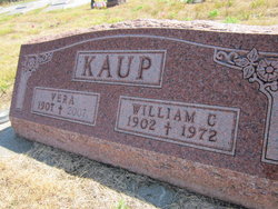
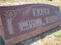
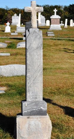
William C. “Bill” Kaup
| Birth | : | 4 Mar 1902 West Point, Cuming County, Nebraska, USA |
| Death | : | 13 Sep 1972 Omaha, Douglas County, Nebraska, USA |
| Burial | : | All Saints Churchyard, Faringdon, Vale of White Horse District, England |
| Coordinate | : | 51.6595730, -1.5839770 |
frequently asked questions (FAQ):
-
Where is William C. “Bill” Kaup's memorial?
William C. “Bill” Kaup's memorial is located at: All Saints Churchyard, Faringdon, Vale of White Horse District, England.
-
When did William C. “Bill” Kaup death?
William C. “Bill” Kaup death on 13 Sep 1972 in Omaha, Douglas County, Nebraska, USA
-
Where are the coordinates of the William C. “Bill” Kaup's memorial?
Latitude: 51.6595730
Longitude: -1.5839770
Family Members:
Parent
Spouse
Siblings

Children
Flowers:


Nearby Cemetories:
1. All Saints Churchyard
Faringdon, Vale of White Horse District, England
Coordinate: 51.6595730, -1.5839770
2. Faringdon Nonconformist Cemetery
Faringdon, Vale of White Horse District, England
Coordinate: 51.6576700, -1.5907200
3. St. Mary's Churchyard
Little Coxwell, Vale of White Horse District, England
Coordinate: 51.6398280, -1.5941840
4. Littleworth Cemetery
Littleworth, Vale of White Horse District, England
Coordinate: 51.6722500, -1.5492500
5. St. Giles Churchyard
Great Coxwell, Vale of White Horse District, England
Coordinate: 51.6389520, -1.6114148
6. St. Faith Churchyard
Shellingford, Vale of White Horse District, England
Coordinate: 51.6394270, -1.5407780
7. Church of Saint Michael and All Angels
Eaton Hastings, Vale of White Horse District, England
Coordinate: 51.6852000, -1.6212000
8. St John the Evangelist Churchyard
Fernham, Vale of White Horse District, England
Coordinate: 51.6251600, -1.5777100
9. Buscot Park
Faringdon, Vale of White Horse District, England
Coordinate: 51.6684973, -1.6518000
10. St George's Parish Church
Hatford, Vale of White Horse District, England
Coordinate: 51.6510000, -1.5120000
11. St Mary the Virgin Parish Churchyard
Longcot, Vale of White Horse District, England
Coordinate: 51.6146420, -1.6056320
12. St. George's Churchyard
Kelmscott, West Oxfordshire District, England
Coordinate: 51.6925550, -1.6408780
13. All Saints Churchyard
Coleshill, Vale of White Horse District, England
Coordinate: 51.6422960, -1.6611320
14. St Nicholas Churchyard
Baulking, Vale of White Horse District, England
Coordinate: 51.6142910, -1.5431850
15. St Deny's Churchyard
Stanford-in-the-Vale, Vale of White Horse District, England
Coordinate: 51.6399960, -1.5062800
16. St George Roman Catholic Churchyard
Buckland, Vale of White Horse District, England
Coordinate: 51.6804300, -1.5068720
17. St Mary Churchyard
Buckland, Vale of White Horse District, England
Coordinate: 51.6819730, -1.5060150
18. St. Stephen's Churchyard
Clanfield, West Oxfordshire District, England
Coordinate: 51.7174060, -1.5911740
19. St Mary Churchyard
Uffington, Vale of White Horse District, England
Coordinate: 51.6018480, -1.5649000
20. St. Mary's Churchyard
Buscot, Vale of White Horse District, England
Coordinate: 51.6815710, -1.6736770
21. Watchfield Military Cemetery
Watchfield, Vale of White Horse District, England
Coordinate: 51.6110800, -1.6469400
22. Watchfield Cemetery
Watchfield, Vale of White Horse District, England
Coordinate: 51.6109220, -1.6467980
23. St. Thomas Churchyard
Watchfield, Vale of White Horse District, England
Coordinate: 51.6107409, -1.6468265
24. All Saints Church
Pusey, Vale of White Horse District, England
Coordinate: 51.6663890, -1.4801330