
| Memorials | : | 0 |
| Location | : | Watchfield, Vale of White Horse District, England |
| Coordinate | : | 51.6107409, -1.6468265 |
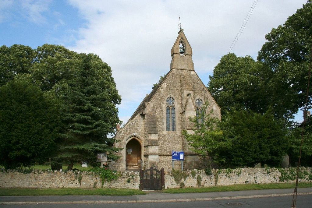
| Description | : | St. Thomas is located on High Street, Watchfield, adjacent to the footpath to the recreation ground and allotments and almost opposite Watchfield Village Hall. The cemetery is run by the Watchfield Parish Council and not the church. In 1922 the cemetery was in Berkshire County. Around the 1970's the county boundaries changed and is now in Oxfordshire County. The cemetery is located seven miles east of Swindon on the M4 Highway about 75 miles from London and Bristol. St. Thomas church is actually a cemetery chapel which is now used as a church and is right in the cemetery. The cemetery is... Read More |
frequently asked questions (FAQ):
-
Where is St. Thomas Churchyard?
St. Thomas Churchyard is located at High Street, Swindon Watchfield, Vale of White Horse District ,Oxfordshire , SN6 8TEEngland.
-
St. Thomas Churchyard cemetery's updated grave count on graveviews.com?
0 memorials
-
Where are the coordinates of the St. Thomas Churchyard?
Latitude: 51.6107409
Longitude: -1.6468265
Nearby Cemetories:
1. Watchfield Cemetery
Watchfield, Vale of White Horse District, England
Coordinate: 51.6109220, -1.6467980
2. Watchfield Military Cemetery
Watchfield, Vale of White Horse District, England
Coordinate: 51.6110800, -1.6469400
3. St. Andrew's Churchyard
Shrivenham, Vale of White Horse District, England
Coordinate: 51.6000270, -1.6537370
4. Shrivenham Parish Cemetery
Shrivenham, Vale of White Horse District, England
Coordinate: 51.5942061, -1.6517227
5. St Mary the Virgin Parish Churchyard
Longcot, Vale of White Horse District, England
Coordinate: 51.6146420, -1.6056320
6. St. James' Churchyard
Sevenhampton, Swindon Unitary Authority, England
Coordinate: 51.6119590, -1.6984440
7. All Saints Churchyard
Coleshill, Vale of White Horse District, England
Coordinate: 51.6422960, -1.6611320
8. St. James Churchyard
Bourton, Cherwell District, England
Coordinate: 51.5794090, -1.6638890
9. St. Giles Churchyard
Great Coxwell, Vale of White Horse District, England
Coordinate: 51.6389520, -1.6114148
10. St Swithun
Compton Beauchamp, Vale of White Horse District, England
Coordinate: 51.5814163, -1.5981875
11. St. Mary's Churchyard
Little Coxwell, Vale of White Horse District, England
Coordinate: 51.6398280, -1.5941840
12. St John the Evangelist Churchyard
Fernham, Vale of White Horse District, England
Coordinate: 51.6251600, -1.5777100
13. Saint Mary Magdalene Church Cemetery
South Marston, Swindon Unitary Authority, England
Coordinate: 51.5903900, -1.7195100
14. Highworth Cemetery
Highworth, Swindon Unitary Authority, England
Coordinate: 51.6285450, -1.7212890
15. All Saints
Woolstone, Vale of White Horse District, England
Coordinate: 51.5870310, -1.5765330
16. St Mary the Virgin Church
Ashbury, Vale of White Horse District, England
Coordinate: 51.5626390, -1.6183810
17. St Mary Churchyard
Uffington, Vale of White Horse District, England
Coordinate: 51.6018480, -1.5649000
18. Buscot Park
Faringdon, Vale of White Horse District, England
Coordinate: 51.6684973, -1.6518000
19. Faringdon Nonconformist Cemetery
Faringdon, Vale of White Horse District, England
Coordinate: 51.6576700, -1.5907200
20. St. Mary the Virgin Churchyard
Bishopstone, Swindon Unitary Authority, England
Coordinate: 51.5519060, -1.6499760
21. All Saints Churchyard
Faringdon, Vale of White Horse District, England
Coordinate: 51.6595730, -1.5839770
22. St Swithun Churchyard Hinton Prava
Swindon Unitary Authority, England
Coordinate: 51.5481447, -1.6669194
23. St Swithun Churchyard Hinton Prava
Swindon Unitary Authority, England
Coordinate: 51.5481447, -1.6669194
24. St Nicholas Churchyard
Baulking, Vale of White Horse District, England
Coordinate: 51.6142910, -1.5431850