

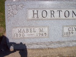
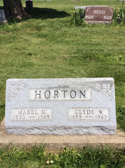
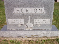
William Carlos “Bill” Horton
| Birth | : | 7 Jun 1909 |
| Death | : | Jan 1972 |
| Burial | : | St. Margaret's Churchyard, Quadring, South Holland District, England |
| Coordinate | : | 52.8903400, -0.1819700 |
| Plot | : | A-16 |
| Description | : | Sunday, January 23, 1972 WILLIAM HORTON, CLEARFIELD, DIES William C. (Bill) Horton, 62, of Clearfield, died at his home early Sunday morning. He had been in poor health for several years. Funeral services were held at 2 p.m. today at the Clearfield United Methodist church. Rev. Ron Kinzler officated. Burial was in the Clearfield cemetery. Mr. Horton had lived in the Clerfield community all of his life. He had been employed at a service station before he became ill. He is survived by two sons, Vernie and John, both of Clearfield; two daughters, Mrs. Kay Douglas of Lenox and Mrs. Cleota Larson of Clearfield; eight... Read More |
frequently asked questions (FAQ):
-
Where is William Carlos “Bill” Horton's memorial?
William Carlos “Bill” Horton's memorial is located at: St. Margaret's Churchyard, Quadring, South Holland District, England.
-
When did William Carlos “Bill” Horton death?
William Carlos “Bill” Horton death on Jan 1972 in
-
Where are the coordinates of the William Carlos “Bill” Horton's memorial?
Latitude: 52.8903400
Longitude: -0.1819700
Family Members:
Parent
Spouse
Siblings

Children
Flowers:


Nearby Cemetories:
1. St. Margaret's Churchyard
Quadring, South Holland District, England
Coordinate: 52.8903400, -0.1819700
2. St. Mary and the Holy Rood Churchyard
Donington, South Holland District, England
Coordinate: 52.9072790, -0.2050080
3. Donington New Cemetery
Donington, South Holland District, England
Coordinate: 52.9071410, -0.2059100
4. Donington Old Cemetery
Donington, South Holland District, England
Coordinate: 52.9091670, -0.2055560
5. St. Peter and St. Paul Churchyard
Gosberton, South Holland District, England
Coordinate: 52.8690870, -0.1629740
6. Gosberton Cemetery
Gosberton, South Holland District, England
Coordinate: 52.8659400, -0.1623000
7. Gosberton Baptist Church
Gosberton, South Holland District, England
Coordinate: 52.8651820, -0.1533940
8. St. Swithin's Churchyard
Bicker, Boston Borough, England
Coordinate: 52.9242080, -0.1798800
9. Bicker Cemetery
Bicker, Boston Borough, England
Coordinate: 52.9261110, -0.1794440
10. St. Peter and St. Paul's Churchyard
Wigtoft, Boston Borough, England
Coordinate: 52.9083330, -0.1236110
11. St Gilbert and St Hugh Churchyard
Gosberton Clough, South Holland District, England
Coordinate: 52.8518081, -0.2166268
12. South Lincolnshire Crematorium
Surfleet, South Holland District, England
Coordinate: 52.8451100, -0.1475110
13. St. Mary's Churchyard
Swineshead, Boston Borough, England
Coordinate: 52.9446490, -0.1596530
14. St. Mary The Virgin Churchyard
Sutterton, Boston Borough, England
Coordinate: 52.9016700, -0.0911111
15. Sutterton Village Cemetery
Sutterton, Boston Borough, England
Coordinate: 52.8994440, -0.0900000
16. Surfleet Cemetery
Surfleet, South Holland District, England
Coordinate: 52.8391670, -0.1383330
17. St. Laurence Churchyard
Surfleet, South Holland District, England
Coordinate: 52.8369500, -0.1436110
18. St. Peter and St. Paul Churchyard
Algarkirk, Boston Borough, England
Coordinate: 52.8995000, -0.0817800
19. St. Mary's Churchyard
Pinchbeck, South Holland District, England
Coordinate: 52.8135340, -0.1589220
20. All Saints Churchyard
Fosdyke, Boston Borough, England
Coordinate: 52.8811100, -0.0469440
21. Church of St. Peter and St. Paul
Kirton, Boston Borough, England
Coordinate: 52.9280560, -0.0597220
22. Fosdyke Village Cemetery
Fosdyke, Boston Borough, England
Coordinate: 52.8808330, -0.0447220
23. St Bartholomew's Church West Pinchbeck
Pinchbeck, South Holland District, England
Coordinate: 52.8080873, -0.2216285
24. Kirton in Holland New Cemetery
Kirton, Boston Borough, England
Coordinate: 52.9361110, -0.0597220