
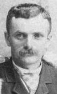


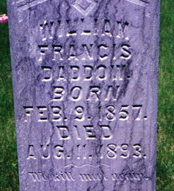
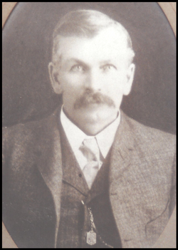
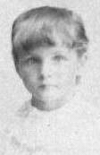
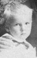
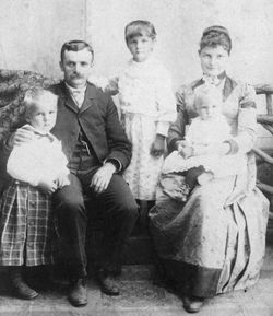
William Francis “Bill” Daddow
| Birth | : | 9 Feb 1857 England |
| Death | : | 11 Aug 1893 Loup City, Sherman County, Nebraska, USA |
| Burial | : | Bunhill Fields Burial Ground, London Borough of Islington, England |
| Coordinate | : | 51.5236015, -0.0888900 |
| Plot | : | In protestant section |
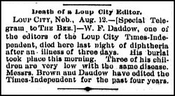
| Description | : | Bill came to America in 1869, when he was age 12 and lived, first in Cuba City, Wisconsin, then in Bremer County, Iowa, and then in about 1881 he came with his parents to settle in Wiggle Creek, on government land (homesteading) four miles south of Loup City, Nebraska. He taught school for a few years. In September 1889 Bill purchased an interest in the Sherman County Times, a newspaper in Loup City. His partnership in the paper was with the paper's editor, Edward "Ed" A. Brown. Then, on Jan 1, 1891 the two men bought total... Read More |
frequently asked questions (FAQ):
-
Where is William Francis “Bill” Daddow's memorial?
William Francis “Bill” Daddow's memorial is located at: Bunhill Fields Burial Ground, London Borough of Islington, England.
-
When did William Francis “Bill” Daddow death?
William Francis “Bill” Daddow death on 11 Aug 1893 in Loup City, Sherman County, Nebraska, USA
-
Where are the coordinates of the William Francis “Bill” Daddow's memorial?
Latitude: 51.5236015
Longitude: -0.0888900
Family Members:
Parent
Spouse
Siblings
Children
Flowers:


Nearby Cemetories:
1. Bunhill Fields Burial Ground
London Borough of Islington, England
Coordinate: 51.5236015, -0.0888900
2. Wesleys Chapel
London Borough of Islington, England
Coordinate: 51.5237140, -0.0865760
3. Quaker Gardens
London, City of London, England
Coordinate: 51.5239250, -0.0911890
4. Bunhill Fields Quaker Burying Ground
Islington, London Borough of Islington, England
Coordinate: 51.5239250, -0.0911890
5. St Luke Churchyard
St Luke's, London Borough of Islington, England
Coordinate: 51.5251312, -0.0941940
6. Old Church of St. Mary Moorfields (Defunct)
London, City of London, England
Coordinate: 51.5187890, -0.0857140
7. St. Giles Cripplegate Churchyard
London, City of London, England
Coordinate: 51.5187100, -0.0939510
8. St Mary's Moorfields Churchyard
London, City of London, England
Coordinate: 51.5177280, -0.0858980
9. Holywell Priory
Shoreditch, London Borough of Hackney, England
Coordinate: 51.5238050, -0.0785300
10. Plague Grave At Seward Street And Mount Mills
Clerkenwell, London Borough of Islington, England
Coordinate: 51.5259780, -0.0985880
11. Liverpool Street Station
London, City of London, England
Coordinate: 51.5187870, -0.0814920
12. Charthouse Chapel and Churchyard
City of London, England
Coordinate: 51.5209310, -0.0987080
13. Priory of St. Mary of Bethlehem Cemetery
Bishopsgate, City of London, England
Coordinate: 51.5183640, -0.0818180
14. St Clement with St Barnabas and St Matthew
Finsbury, London Borough of Islington, England
Coordinate: 51.5277700, -0.0977600
15. Charterhouse
London Borough of Islington, England
Coordinate: 51.5213890, -0.0997220
16. All Hallows on the Wall Churchyard
London, City of London, England
Coordinate: 51.5165990, -0.0843330
17. St Mary Aldermanbury Churchyard
London, City of London, England
Coordinate: 51.5164830, -0.0930720
18. St Albans Churchyard (Defunct)
London, City of London, England
Coordinate: 51.5166460, -0.0940880
19. St. Leonard Churchyard
Shoreditch, London Borough of Hackney, England
Coordinate: 51.5268230, -0.0773640
20. Guildhall
London, City of London, England
Coordinate: 51.5158200, -0.0911380
21. St Bartholomew the Great Churchyard
London, City of London, England
Coordinate: 51.5189300, -0.0995360
22. St Botolph Church
Bishopsgate, City of London, England
Coordinate: 51.5167080, -0.0816560
23. St. Botholph without Bishopsgate
Finsbury, London Borough of Islington, England
Coordinate: 51.5166840, -0.0815590
24. Austin Friars Churchyard
Broad Street, City of London, England
Coordinate: 51.5155030, -0.0854620