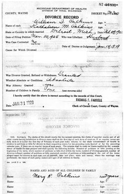
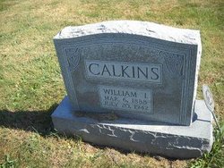
William Isaac Calkins
| Birth | : | 6 Mar 1888 Lucas County, Iowa, USA |
| Death | : | 20 Jul 1942 Hines, Cook County, Illinois, USA |
| Burial | : | Burpham Churchyard, Guildford, Guildford Borough, England |
| Coordinate | : | 51.2622640, -0.5497350 |
| Plot | : | Sec 4 Row 2 |
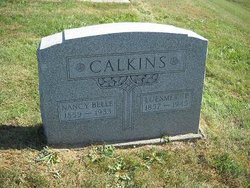
| Description | : | Husband of Ruth LaValley, Kathleen Marie Maloney, divorced and Margaret Ellen Meehan. Son of Luesmer Pearson Calkins and Nancy Belle Webber OBITUARY THE CHARITON LEADER Chariton, Iowa Tuesday, August 4, 1942 WILLIAM ISAAC CALKINS William Isaac Calkins, youngest son of L. P. and Belle Webber Calkins, was born on a farm in Lucas county, Iowa, March 6, 1888. There he attended the public schools and while a young lad, united with the Methodist church in Derby with his older brothers. Later he attended the C. C. Business College in Des Moines. Then, after leaving the farm, he worked with the L. W. Holly Bank Office Supplies... Read More |
frequently asked questions (FAQ):
-
Where is William Isaac Calkins's memorial?
William Isaac Calkins's memorial is located at: Burpham Churchyard, Guildford, Guildford Borough, England.
-
When did William Isaac Calkins death?
William Isaac Calkins death on 20 Jul 1942 in Hines, Cook County, Illinois, USA
-
Where are the coordinates of the William Isaac Calkins's memorial?
Latitude: 51.2622640
Longitude: -0.5497350
Family Members:
Parent
Spouse
Siblings
Children
Flowers:
Nearby Cemetories:
1. Burpham Churchyard
Guildford, Guildford Borough, England
Coordinate: 51.2622640, -0.5497350
2. St Edward the Confessor Churchyard
Sutton Green, Woking Borough, England
Coordinate: 51.2741930, -0.5608230
3. St Mary the Virgin Churchyard
Send, Guildford Borough, England
Coordinate: 51.2791230, -0.5408600
4. St. John's Churchyard
Stoke-next-Guildford, Guildford Borough, England
Coordinate: 51.2470280, -0.5711690
5. St John the Evangelist Churchyard
Merrow, Guildford Borough, England
Coordinate: 51.2459770, -0.5271350
6. Stoke New Cemetery
Guildford, Guildford Borough, England
Coordinate: 51.2543900, -0.5824700
7. Stoke Old Cemetery
Guildford, Guildford Borough, England
Coordinate: 51.2522600, -0.5828500
8. Society of Friends Burial Ground (Defunct)
Guildford, Guildford Borough, England
Coordinate: 51.2364500, -0.5703050
9. Send Cemetery
Send, Guildford Borough, England
Coordinate: 51.2876880, -0.5273440
10. Holy Trinity Church
Guildford, Guildford Borough, England
Coordinate: 51.2357740, -0.5705540
11. St. Peter & St. Paul's Churchyard
West Clandon, Guildford Borough, England
Coordinate: 51.2507990, -0.5053760
12. Ss Peter & Paul Church Cemetery
West Clandon, Guildford Borough, England
Coordinate: 51.2517500, -0.5045400
13. St Edwards Churchyard
Guildford, Guildford Borough, England
Coordinate: 51.2339770, -0.5719760
14. St Marys Churchyard
Guildford, Guildford Borough, England
Coordinate: 51.2346622, -0.5744170
15. Saint Nicolas Parish Church
Guildford, Guildford Borough, England
Coordinate: 51.2346980, -0.5776620
16. St Mary the Virgin Churchyard
Worplesdon, Guildford Borough, England
Coordinate: 51.2730100, -0.6067360
17. Guildford Cemetery
Guildford, Guildford Borough, England
Coordinate: 51.2312960, -0.5832800
18. St Martha-on-the-Hill Churchyard
Chilworth, Guildford Borough, England
Coordinate: 51.2246400, -0.5290440
19. St Peter's Church
Old Woking, Woking Borough, England
Coordinate: 51.3017410, -0.5372560
20. Old Woking Burial Ground
Old Woking, Woking Borough, England
Coordinate: 51.3026230, -0.5351320
21. St Mary the Virgin Churchyard
Shalford, Guildford Borough, England
Coordinate: 51.2206700, -0.5705520
22. Shalford Cemetery
Shalford, Guildford Borough, England
Coordinate: 51.2152000, -0.5687000
23. St Mary Magdalen Churchyard
Ripley, Guildford Borough, England
Coordinate: 51.2992230, -0.4936400
24. St Peter and St Paul Churchyard
Albury, Guildford Borough, England
Coordinate: 51.2181500, -0.4974400

