
| Birth | : | 14 Sep 1928 Russellville, Cole County, Missouri, USA |
| Death | : | 5 Mar 2014 Olean, Miller County, Missouri, USA |
| Burial | : | Allen Cemetery, Olean, Miller County, USA |
| Coordinate | : | 38.4150009, -92.5008011 |
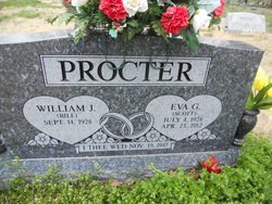
| Description | : | Phillips Funeral Home, March 2014 William J. "Billy Joe" Procter, 85, of Olean, Missouri passed away Wednesday March 5, 2014 at his residence in Olean, Missouri. On September 14, 1928 he was born in Russellville, Missouri, the son of the late William C. and May (Williams) Procter. On November 19, 1947 in Eldon, Missouri he was united in marriage to Eva Grace (Scott) Procter who preceded him in death on April 23, 2012. Survivors: children and spouses: Ronald J. and Christie J. Procter of Claremore, OK; Mike and Linda Procter of Eldon, MO; Cynthia and John Cronenberg of Olean, MO;... Read More |
frequently asked questions (FAQ):
-
Where is William J. “Billy Joe” Procter's memorial?
William J. “Billy Joe” Procter's memorial is located at: Allen Cemetery, Olean, Miller County, USA.
-
When did William J. “Billy Joe” Procter death?
William J. “Billy Joe” Procter death on 5 Mar 2014 in Olean, Miller County, Missouri, USA
-
Where are the coordinates of the William J. “Billy Joe” Procter's memorial?
Latitude: 38.4150009
Longitude: -92.5008011
Family Members:
Parent

Spouse
Siblings
Flowers:


Nearby Cemetories:
1. Allen Cemetery
Olean, Miller County, USA
Coordinate: 38.4150009, -92.5008011
2. Olean Cemetery
Olean, Miller County, USA
Coordinate: 38.4131012, -92.5413971
3. Farris Cemetery
Moniteau County, USA
Coordinate: 38.4369900, -92.5380000
4. Jackson Chapel Methodist Church Cemetery
California, Moniteau County, USA
Coordinate: 38.4447900, -92.5286500
5. Walker Cemetery
Moniteau County, USA
Coordinate: 38.4338989, -92.5522003
6. Etter-Walker Cemetery
Burris Fork, Moniteau County, USA
Coordinate: 38.4333700, -92.5525400
7. Green Ridge Baptist Church Cemetery
Eldon, Miller County, USA
Coordinate: 38.4116200, -92.5645700
8. Gray Cemetery
Moniteau County, USA
Coordinate: 38.4536018, -92.5456009
9. Bruce-Lewis-McGahan Cemetery
Enon, Moniteau County, USA
Coordinate: 38.4667500, -92.5172100
10. Rock Enon Cemetery
Miller County, USA
Coordinate: 38.4668400, -92.5170700
11. Mount Pleasant Cemetery
Eldon, Miller County, USA
Coordinate: 38.3667700, -92.5300800
12. Matheis Cemetery
Russellville, Cole County, USA
Coordinate: 38.4571800, -92.4491600
13. Mount Vernon Cemetery
Eldon, Miller County, USA
Coordinate: 38.3624992, -92.5606003
14. Salem Cemetery
Saline Township, Miller County, USA
Coordinate: 38.3691232, -92.5697260
15. Salem Cemetery
Eldon, Miller County, USA
Coordinate: 38.3697014, -92.5714035
16. Hite Cemetery
Miller County, USA
Coordinate: 38.4039001, -92.5935974
17. Spring Garden Cemetery
Spring Garden, Miller County, USA
Coordinate: 38.3922005, -92.4111023
18. Enon Cemetery
Russellville, Cole County, USA
Coordinate: 38.4888992, -92.4730988
19. Roark Cemetery
Russellville, Cole County, USA
Coordinate: 38.4696999, -92.4255981
20. Karnes-Carney-Henderson Cemetery
Burris Fork, Moniteau County, USA
Coordinate: 38.4992100, -92.5007510
21. Eldon Cemetery
Eldon, Miller County, USA
Coordinate: 38.3642006, -92.5868988
22. Belleville Cemetery
Russellville, Cole County, USA
Coordinate: 38.4970490, -92.4667150
23. Campbell Cemetery
Cole County, USA
Coordinate: 38.4810982, -92.4297028
24. Farmer Cemetery
Hickory Hill, Cole County, USA
Coordinate: 38.4143500, -92.3889790