
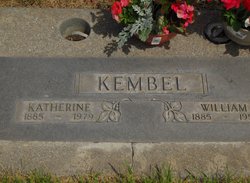
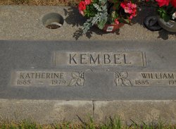
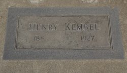
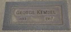
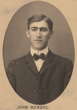
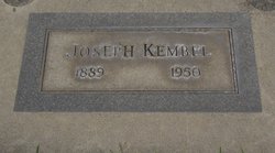
William Kembel
| Birth | : | 12 Sep 1885 |
| Death | : | 6 Nov 1958 Spokane, Spokane County, Washington, USA |
| Burial | : | Thirsk Cemetery, Thirsk, Hambleton District, England |
| Coordinate | : | 54.2356140, -1.3493790 |
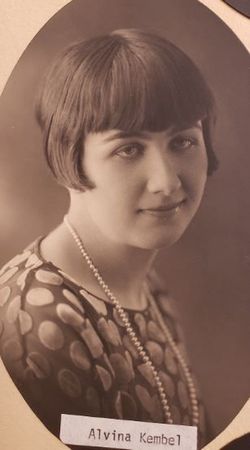
| Description | : | Ritzville Journal-Times, Thursday, November 13, 1958 Kembel Rites Held Saturday Funeral services for William Kembel, 73, were held Saturday from the Philadelphia Congregational church in Ritzville. Kembel made his home at 716 E. Bismark, Spokane. He was a former resident of Ritzville. The Rev. Herbert C. Haemmelmann officated. Interment was in the Ritzville Memorial cemetery. Danekas and Duncan funeral home was in charge of arrangements. He was born Sept. 12, 1885, and was a member of the Congregational church. Survivors include his wife, Katherine, at the home; four daughters, Mrs. Alvina Meyer of Ritzville, Mrs. Lorena Crisp of Spokane, Mrs. Nettie... Read More |
frequently asked questions (FAQ):
-
Where is William Kembel's memorial?
William Kembel's memorial is located at: Thirsk Cemetery, Thirsk, Hambleton District, England.
-
When did William Kembel death?
William Kembel death on 6 Nov 1958 in Spokane, Spokane County, Washington, USA
-
Where are the coordinates of the William Kembel's memorial?
Latitude: 54.2356140
Longitude: -1.3493790
Family Members:
Parent
Spouse
Siblings
Children
Flowers:


Nearby Cemetories:
1. Thirsk Cemetery
Thirsk, Hambleton District, England
Coordinate: 54.2356140, -1.3493790
2. St. Mary's Churchyard
Thirsk, Hambleton District, England
Coordinate: 54.2349200, -1.3454900
3. Friends Burial Ground
Thirsk, Hambleton District, England
Coordinate: 54.2336160, -1.3444510
4. Wesleyan Methodist Burial Ground
Thirsk, Hambleton District, England
Coordinate: 54.2350990, -1.3408244
5. St Oswald Churchyard
Sowerby, Hambleton District, England
Coordinate: 54.2261950, -1.3404430
6. St Wilfrid Churchyard
South Kilvington, Hambleton District, England
Coordinate: 54.2499690, -1.3481640
7. St Lawrence Churchyard
Carlton Miniott, Hambleton District, England
Coordinate: 54.2232500, -1.3958700
8. St Leonard Churchyard
Thornton-le-Street, Hambleton District, England
Coordinate: 54.2700040, -1.3653200
9. St Leonard Church Cemetery
Sandhutton, Hambleton District, England
Coordinate: 54.2325700, -1.4110600
10. St Leonard Churchyard
Sandhutton, Hambleton District, England
Coordinate: 54.2326000, -1.4121600
11. St Mary Churchyard
Bagby, Hambleton District, England
Coordinate: 54.2192130, -1.2907820
12. St Felix Churchyard
Felixkirk, Hambleton District, England
Coordinate: 54.2564000, -1.2832000
13. St John the Baptist Churchyard
Kirby Wiske, Hambleton District, England
Coordinate: 54.2576320, -1.4238510
14. All Saints Churchyard
Great Thirkleby, Hambleton District, England
Coordinate: 54.2020800, -1.2762700
15. St John the Evangelist Churchyard
Dalton, Hambleton District, England
Coordinate: 54.1806400, -1.3341500
16. St John Churchyard
Skipton-on-Swale, Hambleton District, England
Coordinate: 54.2130000, -1.4379000
17. St. Wilfrid's Churchyard
Kirby Knowle, Hambleton District, England
Coordinate: 54.2788910, -1.2823040
18. St. Barnabas Church Cemetery
Thornton-le-Moor, Hambleton District, England
Coordinate: 54.2874720, -1.4011833
19. St Columba Churchyard
Topcliffe, Hambleton District, England
Coordinate: 54.1785070, -1.3892590
20. Topcliffe Cemetery
Topcliffe, Hambleton District, England
Coordinate: 54.1774200, -1.3846100
21. St Andrew Churchyard
South Otterington, Hambleton District, England
Coordinate: 54.2823100, -1.4311300
22. Holy Trinity Churchyard
Boltby, Hambleton District, England
Coordinate: 54.2732340, -1.2480700
23. All Saints Churchyard
Pickhill, Hambleton District, England
Coordinate: 54.2470500, -1.4700700
24. St James Churchyard
Baldersby, Harrogate Borough, England
Coordinate: 54.1867500, -1.4405600