
| Birth | : | 19 Apr 1835 Canada |
| Death | : | 25 Mar 1904 |
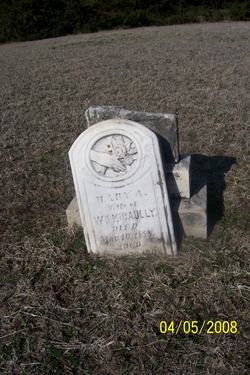
| Burial | : | Pleasant Valley Cemetery, Oak Hill, Clay County, USA |
| Coordinate | : | 39.2468987, -97.2889023 |
| Description | : | The Times Clay Center, KS Thursday, March 31, 1904 Page 1, Columns 3 & 4 Another Death. Friday of last week William McGaulley of this city died at the home of his daughter, Mrs. Charles Anderson, in this city. The funeral was held Monday morning at 9 o’clock from the home, conducted by Rev. Whitmer, and the remains were taken to Pleasant Valley cemetery near Oak Hill for burial. Mr. McGaulley was one of the old settlers of the county, having come here in the early seventies. He homesteaded near Oak Hill, where he lived for a number of years. It was about... Read More |
frequently asked questions (FAQ):
-
Where is William McGaully's memorial?
William McGaully's memorial is located at: Pleasant Valley Cemetery, Oak Hill, Clay County, USA.
-
When did William McGaully death?
William McGaully death on 25 Mar 1904 in
-
Where are the coordinates of the William McGaully's memorial?
Latitude: 39.2468987
Longitude: -97.2889023
Family Members:
Spouse
Children

Flowers:


Nearby Cemetories:
1. Pleasant Valley Cemetery
Oak Hill, Clay County, USA
Coordinate: 39.2468987, -97.2889023
2. Wesleyan Cemetery
Oak Hill, Clay County, USA
Coordinate: 39.2268982, -97.2572021
3. Rose Meron Cemetery
Oak Hill, Clay County, USA
Coordinate: 39.2194700, -97.3338900
4. Table Mound Cemetery
Idana, Clay County, USA
Coordinate: 39.3141300, -97.2792300
5. Hebron Cemetery
Clay County, USA
Coordinate: 39.3213800, -97.2601400
6. Pleasant Ridge Cemetery
Clay County, USA
Coordinate: 39.2789001, -97.1841965
7. Shields Cemetery
Clay County, USA
Coordinate: 39.3208008, -97.3507996
8. Idana Cemetery
Idana, Clay County, USA
Coordinate: 39.3574500, -97.2693300
9. Athelstane Cemetery
Athelstane Township, Clay County, USA
Coordinate: 39.1768990, -97.1753006
10. Zion Lutheran Cemetery
Clay County, USA
Coordinate: 39.2928009, -97.1557999
11. Mount Liberty Church Cemetery
Ottawa County, USA
Coordinate: 39.2489400, -97.4356200
12. Swartwood Cemetery
Longford, Clay County, USA
Coordinate: 39.1323200, -97.3431500
13. Keystone Cemetery
Manchester, Dickinson County, USA
Coordinate: 39.1185989, -97.2917023
14. Mizpah Cemetery
Clay County, USA
Coordinate: 39.2057800, -97.1238500
15. Republican City Cemetery
Clay Center, Clay County, USA
Coordinate: 39.3431015, -97.1628036
16. Miltonvale Cemetery
Miltonvale, Cloud County, USA
Coordinate: 39.3358002, -97.4447021
17. Uniondale Cemetery
Wakefield, Clay County, USA
Coordinate: 39.2382800, -97.0918400
18. Wilson Cemetery
Clay County, USA
Coordinate: 39.3800011, -97.1896973
19. Smith Grave
Miltonvale, Cloud County, USA
Coordinate: 39.3645300, -97.4308700
20. Vine Creek Cemetery
Ottawa County, USA
Coordinate: 39.1194000, -97.4180984
21. Saint John's Episcopal Cemetery
Clay County, USA
Coordinate: 39.2193985, -97.0744019
22. Greenridge Cemetery
Dickinson County, USA
Coordinate: 39.1199989, -97.1433029
23. Milo Chapman Gravesite
Broughton, Clay County, USA
Coordinate: 39.2888500, -97.0724400
24. Lincoln Cemetery
Clay Center, Clay County, USA
Coordinate: 39.4230995, -97.2930984