
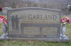
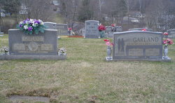
William Odell Garland
| Birth | : | 7 May 1890 Carter County, Tennessee, USA |
| Death | : | 21 Mar 1969 Carter County, Tennessee, USA |
| Burial | : | All Saints Churchyard, Appleton Roebuck, Selby District, England |
| Coordinate | : | 53.8734600, -1.1580870 |
frequently asked questions (FAQ):
-
Where is William Odell Garland's memorial?
William Odell Garland's memorial is located at: All Saints Churchyard, Appleton Roebuck, Selby District, England.
-
When did William Odell Garland death?
William Odell Garland death on 21 Mar 1969 in Carter County, Tennessee, USA
-
Where are the coordinates of the William Odell Garland's memorial?
Latitude: 53.8734600
Longitude: -1.1580870
Family Members:
Parent

Spouse

Siblings
Children
Flowers:


Nearby Cemetories:
1. Nun Appleton Priory
Appleton Roebuck, Selby District, England
Coordinate: 53.8525000, -1.1561110
2. St John Churchyard
Acaster Selby, Selby District, England
Coordinate: 53.8614750, -1.1283740
3. All Saints Churchyard
Bolton Percy, Selby District, England
Coordinate: 53.8649780, -1.1929000
4. All Saints Churchyard
Ryther, Selby District, England
Coordinate: 53.8478600, -1.1576100
5. St Paul Churchyard
Colton, Selby District, England
Coordinate: 53.8964660, -1.1773770
6. St Helen Churchyard
Stillingfleet, Selby District, England
Coordinate: 53.8618710, -1.0994760
7. Moor Lane Burial Ground
Copmanthorpe, York Unitary Authority, England
Coordinate: 53.9096890, -1.1449400
8. Rythergate Cemetery
Cawood, Selby District, England
Coordinate: 53.8356000, -1.1347700
9. St Giles Churchyard
Copmanthorpe, York Unitary Authority, England
Coordinate: 53.9149240, -1.1410420
10. St James Churchyard
Bilbrough, Selby District, England
Coordinate: 53.9119110, -1.1945130
11. St John the Baptist Churchyard
Kirkby Wharfe, Selby District, England
Coordinate: 53.8627400, -1.2320400
12. All Saints Churchyard
Cawood, Selby District, England
Coordinate: 53.8331970, -1.1235660
13. St John the Baptist Churchyard Extension
Kirkby Wharfe, Selby District, England
Coordinate: 53.8602100, -1.2321200
14. Holy Trinity Churchyard
Acaster Malbis, York Unitary Authority, England
Coordinate: 53.9052480, -1.0975170
15. St Matthew Churchyard
Naburn, York Unitary Authority, England
Coordinate: 53.9009520, -1.0899200
16. St Mary Churchyard
Askham Richard, York Unitary Authority, England
Coordinate: 53.9254100, -1.1836800
17. St Nicholas Churchyard
Askham Bryan, York Unitary Authority, England
Coordinate: 53.9294600, -1.1581240
18. St Mary the Virgin Churchyard
Church Fenton, Selby District, England
Coordinate: 53.8243100, -1.2203500
19. Dringhouses Cemetery
York, York Unitary Authority, England
Coordinate: 53.9297740, -1.1156780
20. St. Andrew's Old Churchyard
Bishopthorpe, York Unitary Authority, England
Coordinate: 53.9221490, -1.0929640
21. St Andrew Churchyard
Bishopthorpe, York Unitary Authority, England
Coordinate: 53.9236690, -1.0955320
22. St Mary the Virgin Churchyard
Tadcaster, Selby District, England
Coordinate: 53.8852300, -1.2624100
23. Inghamite Chapel
Tadcaster, Selby District, England
Coordinate: 53.8843580, -1.2644470
24. York Crematorium
York, York Unitary Authority, England
Coordinate: 53.9264970, -1.0936130