

Wilma Jean Allen Brown
| Birth | : | 20 May 1930 Switzerland County, Indiana, USA |
| Death | : | 27 Feb 2006 Hanover, Jefferson County, Indiana, USA |
| Burial | : | St John the Baptist Churchyard, Burscough, West Lancashire District, England |
| Coordinate | : | 53.6042760, -2.8401390 |
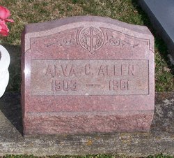
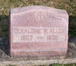
| Description | : | Madison Courier Madison, Indiana March 1, 2006 Wilma Jean Allen Brown, 75, of Moorefield died Monday, Feb. 27, 2006, at Thornton Terrace Health Campus in Hanover. She was born May 20, 1930, in Switzerland County, the daughter of Alva C. and Geraldine Wiley Allen. She was raised in Switzerland County and had lived in Moorefield since 1946. She was a bookkeeper for the former U.S. Shoe Corp. at its Vevay plant, having been the first employee hired there. She was a member and past elder at the Caledonia Presbyterian Church in Moorefield. In her spare time she enjoyed gardening, reading and writing. Surviving are one... Read More |
frequently asked questions (FAQ):
-
Where is Wilma Jean Allen Brown's memorial?
Wilma Jean Allen Brown's memorial is located at: St John the Baptist Churchyard, Burscough, West Lancashire District, England.
-
When did Wilma Jean Allen Brown death?
Wilma Jean Allen Brown death on 27 Feb 2006 in Hanover, Jefferson County, Indiana, USA
-
Where are the coordinates of the Wilma Jean Allen Brown's memorial?
Latitude: 53.6042760
Longitude: -2.8401390
Family Members:
Parent
Spouse
Siblings


Nearby Cemetories:
1. St John the Baptist Churchyard
Burscough, West Lancashire District, England
Coordinate: 53.6042760, -2.8401390
2. St John The Evangelist Roman Catholic Church
Burscough, West Lancashire District, England
Coordinate: 53.5902152, -2.8424163
3. Burscough Priory
Burscough, West Lancashire District, England
Coordinate: 53.5830270, -2.8565030
4. Lathom Park Chapel
Lathom, West Lancashire District, England
Coordinate: 53.5782510, -2.8216720
5. West Lancashire Cemetery and Crematorium
Burscough, West Lancashire District, England
Coordinate: 53.5875500, -2.8820300
6. St. Mary the Virgin Churchyard
Rufford, West Lancashire District, England
Coordinate: 53.6349960, -2.8126410
7. Christchurch Churchyard
Newburgh, West Lancashire District, England
Coordinate: 53.5876845, -2.7842440
8. St. Peter's Churchyard
Mawdesley, Chorley Borough, England
Coordinate: 53.6237600, -2.7734100
9. St Peter and St Paul Churchyard
Ormskirk, West Lancashire District, England
Coordinate: 53.5692640, -2.8877690
10. St. James Churchyard
Westhead, West Lancashire District, England
Coordinate: 53.5582324, -2.8527492
11. Our Lady and All Saints Roman Catholic
Parbold, West Lancashire District, England
Coordinate: 53.5911900, -2.7644350
12. St. Elizabeth's Churchyard
Scarisbrick, West Lancashire District, England
Coordinate: 53.6124460, -2.9206340
13. Saint Anne's Roman Catholic Church Cemetery
Ormskirk, West Lancashire District, England
Coordinate: 53.5626520, -2.8935560
14. Christ Church Churchyard
Parbold, West Lancashire District, England
Coordinate: 53.5908500, -2.7531900
15. St. Michael's Churchyard
Dalton, West Lancashire District, England
Coordinate: 53.5670360, -2.7640390
16. Christ Churchyard
Aughton, West Lancashire District, England
Coordinate: 53.5583510, -2.9046990
17. St. Mark Churchyard
Scarisbrick, West Lancashire District, England
Coordinate: 53.6134600, -2.9403800
18. St. Peter and St. Paul Churchyard
Mawdesley, Chorley Borough, England
Coordinate: 53.6266580, -2.7451420
19. St. Paul's Churchyard
Skelmersdale, West Lancashire District, England
Coordinate: 53.5502050, -2.7929450
20. Skelmersdale Cemetery
Skelmersdale, West Lancashire District, England
Coordinate: 53.5446820, -2.8131570
21. St. Richard's Roman Catholic Cemetery
Skelmersdale, West Lancashire District, England
Coordinate: 53.5442920, -2.8143760
22. Croston Cemetery
Croston, Chorley Borough, England
Coordinate: 53.6586700, -2.7733100
23. St. Cuthbert's Churchyard
Halsall, West Lancashire District, England
Coordinate: 53.5852140, -2.9529650
24. St. Mary's Churchyard
Tarleton, West Lancashire District, England
Coordinate: 53.6746100, -2.8239200