
| Birth | : | 1 Jan 1940 Polk County, Missouri, USA |
| Death | : | 8 Feb 2018 Columbia, Boone County, Missouri, USA |
| Burial | : | Allen Cemetery, Olean, Miller County, USA |
| Coordinate | : | 38.4150009, -92.5008011 |
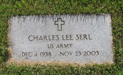
| Description | : | Wilma June Serl, 78, of Jefferson City passed away Thursday, February 8, 2018, at University Hospital in Columbia, Missouri. She was born January 1, 1940, in Polk County, Missouri, the daughter of the late Elmer Claud and Lola Mae (Coonis) Breshears. June was one of four children born to Elmer and Lola: Wilma, Lori, Twyla, and Erma. June was united in marriage on January 11, 1959, at Mt. Herman Baptist Church in Olean, Missouri to Charles Lee Serl who preceded her in death on November 23, 2003. June was a devoted wife and homemaker.... Read More |
frequently asked questions (FAQ):
-
Where is Wilma June Breshears Serl's memorial?
Wilma June Breshears Serl's memorial is located at: Allen Cemetery, Olean, Miller County, USA.
-
When did Wilma June Breshears Serl death?
Wilma June Breshears Serl death on 8 Feb 2018 in Columbia, Boone County, Missouri, USA
-
Where are the coordinates of the Wilma June Breshears Serl's memorial?
Latitude: 38.4150009
Longitude: -92.5008011
Family Members:
Parent

Spouse
Siblings
Flowers:


Nearby Cemetories:
1. Allen Cemetery
Olean, Miller County, USA
Coordinate: 38.4150009, -92.5008011
2. Olean Cemetery
Olean, Miller County, USA
Coordinate: 38.4131012, -92.5413971
3. Farris Cemetery
Moniteau County, USA
Coordinate: 38.4369900, -92.5380000
4. Jackson Chapel Methodist Church Cemetery
California, Moniteau County, USA
Coordinate: 38.4447900, -92.5286500
5. Walker Cemetery
Moniteau County, USA
Coordinate: 38.4338989, -92.5522003
6. Etter-Walker Cemetery
Burris Fork, Moniteau County, USA
Coordinate: 38.4333700, -92.5525400
7. Green Ridge Baptist Church Cemetery
Eldon, Miller County, USA
Coordinate: 38.4116200, -92.5645700
8. Gray Cemetery
Moniteau County, USA
Coordinate: 38.4536018, -92.5456009
9. Bruce-Lewis-McGahan Cemetery
Enon, Moniteau County, USA
Coordinate: 38.4667500, -92.5172100
10. Rock Enon Cemetery
Miller County, USA
Coordinate: 38.4668400, -92.5170700
11. Mount Pleasant Cemetery
Eldon, Miller County, USA
Coordinate: 38.3667700, -92.5300800
12. Matheis Cemetery
Russellville, Cole County, USA
Coordinate: 38.4571800, -92.4491600
13. Mount Vernon Cemetery
Eldon, Miller County, USA
Coordinate: 38.3624992, -92.5606003
14. Salem Cemetery
Saline Township, Miller County, USA
Coordinate: 38.3691232, -92.5697260
15. Salem Cemetery
Eldon, Miller County, USA
Coordinate: 38.3697014, -92.5714035
16. Hite Cemetery
Miller County, USA
Coordinate: 38.4039001, -92.5935974
17. Spring Garden Cemetery
Spring Garden, Miller County, USA
Coordinate: 38.3922005, -92.4111023
18. Enon Cemetery
Russellville, Cole County, USA
Coordinate: 38.4888992, -92.4730988
19. Roark Cemetery
Russellville, Cole County, USA
Coordinate: 38.4696999, -92.4255981
20. Karnes-Carney-Henderson Cemetery
Burris Fork, Moniteau County, USA
Coordinate: 38.4992100, -92.5007510
21. Eldon Cemetery
Eldon, Miller County, USA
Coordinate: 38.3642006, -92.5868988
22. Belleville Cemetery
Russellville, Cole County, USA
Coordinate: 38.4970490, -92.4667150
23. Campbell Cemetery
Cole County, USA
Coordinate: 38.4810982, -92.4297028
24. Farmer Cemetery
Hickory Hill, Cole County, USA
Coordinate: 38.4143500, -92.3889790