
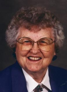
Zella B. Buck Benson
| Birth | : | 22 Apr 1908 Iowa, USA |
| Death | : | 7 Nov 2006 Iowa, USA |
| Burial | : | Queen of Peace Cemetery, Raub, McLean County, USA |
| Coordinate | : | 47.7458000, -102.0532990 |
| Description | : | Zella was born in State Center, Iowa, the daughter of Corydon and Mary Olive Buck. She was a graduate of Lamoille High School and attended business college in Des Moines, Iowa. On November 19, 1934, Zella was married to Carl Benson at the Little Brown Church in Nashua, Iowa. The couple live in Marshalltown until 1937, when they moved to Grinnell to make their home. Carl and Zella owned and operated the Benson Turkey Farm from 1937 - 1973. After retirement, Carl and Zella enjoyed trout fishing, camping and traveling. After the death of her husband in 1984, Zella continued... Read More |
frequently asked questions (FAQ):
-
Where is Zella B. Buck Benson's memorial?
Zella B. Buck Benson's memorial is located at: Queen of Peace Cemetery, Raub, McLean County, USA.
-
When did Zella B. Buck Benson death?
Zella B. Buck Benson death on 7 Nov 2006 in Iowa, USA
-
Where are the coordinates of the Zella B. Buck Benson's memorial?
Latitude: 47.7458000
Longitude: -102.0532990
Family Members:
Parent
Siblings
Flowers:


Nearby Cemetories:
1. Queen of Peace Cemetery
Raub, McLean County, USA
Coordinate: 47.7458000, -102.0532990
2. Bethesda Lutheran Church Cemetery
Raub, McLean County, USA
Coordinate: 47.7461800, -102.0486800
3. Church of God Cemetery
Raub, McLean County, USA
Coordinate: 47.8041344, -102.0656662
4. Memorial Congregational Church Cemetery
Raub, McLean County, USA
Coordinate: 47.7030900, -102.1339600
5. Roseglen Baptist Cemetery
Roseglen, McLean County, USA
Coordinate: 47.7738991, -101.9246979
6. Bethlehem Lutheran Cemetery
Roseglen, McLean County, USA
Coordinate: 47.7602882, -101.9143037
7. Lucky Mound Lutheran Cemetery
McLean County, USA
Coordinate: 47.8338990, -102.0010640
8. Immaculate Conception Cemetery
Raub, McLean County, USA
Coordinate: 47.6309540, -102.0590190
9. Indian Scout Cemetery
McLean County, USA
Coordinate: 47.6472015, -101.9175034
10. Arickara Congregational Cemetery
McLean County, USA
Coordinate: 47.6596990, -101.8448640
11. Emrich Cemetery
Roseglen, McLean County, USA
Coordinate: 47.7947180, -101.8082670
12. Immanuel Lutheran Cemetery
Roseglen, McLean County, USA
Coordinate: 47.7315070, -101.7976600
13. Roseglen Cemetery
Roseglen, McLean County, USA
Coordinate: 47.7238998, -101.7636032
14. Parshall Cemetery
Parshall, Mountrail County, USA
Coordinate: 47.9357200, -102.1282000
15. Crowsheart Cemetery
Dunn County, USA
Coordinate: 47.5797005, -102.2322006
16. Hiddenwood Cemetery
McLean County, USA
Coordinate: 47.8330994, -101.7743988
17. Saint Bridgets Cemetery
Parshall, Mountrail County, USA
Coordinate: 47.9622700, -102.1328910
18. Medicine Stone Cemetery
Mercer County, USA
Coordinate: 47.5367012, -102.1706009
19. Independence Congregational Church Cemetery
Dunn County, USA
Coordinate: 47.6944300, -102.3767700
20. Saint Pauls Lutheran Cemetery
Makoti, Ward County, USA
Coordinate: 47.9057560, -101.8191380
21. First Lutheran Wabek Cemetery
Wabek, Mountrail County, USA
Coordinate: 47.9633300, -101.9691000
22. Bureau of Catholic Indian Missions Cemetery
McLean County, USA
Coordinate: 47.5677460, -101.8410090
23. Saint Josephs Catholic Cemetery
Twin Buttes, Dunn County, USA
Coordinate: 47.5420418, -102.2067841
24. Holen Cemetery
Mercer County, USA
Coordinate: 47.5149994, -102.1433029