
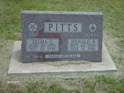
Zelma Estelle Champlin Pitts
| Birth | : | 29 Jun 1909 Smith Center, Smith County, Kansas, USA |
| Death | : | 13 Nov 1998 Jamestown, Cloud County, Kansas, USA |
| Burial | : | Hillside Cemetery, Rochester, Plymouth County, USA |
| Coordinate | : | 41.7750015, -70.7889023 |
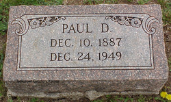
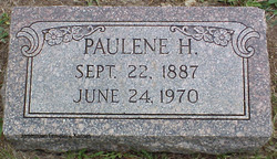
| Description | : | Zelma was the daughter of Paul DeForest Champlin & Pauline Henrietta Johnson Zelma Estelle Pitts, 89, died Nov. 13, 1998, at Smith County Memorial Hospital. She was born June 26, 1909, at Jamestown, the daughter of Paul D. and Pauline H. (Johnson) Champlin. Her parents moved to Gaylord in 1911 and she attended grade school there. She graduated from Cawker City High School in 1927, then worked as a dental assistant for Dr. S. R. Bram for eight years. Zelma entered nurse training at St. Luke's Hospital in Kansas City, Mo., in February 1939. She graduated in 1939 and... Read More |
frequently asked questions (FAQ):
-
Where is Zelma Estelle Champlin Pitts's memorial?
Zelma Estelle Champlin Pitts's memorial is located at: Hillside Cemetery, Rochester, Plymouth County, USA.
-
When did Zelma Estelle Champlin Pitts death?
Zelma Estelle Champlin Pitts death on 13 Nov 1998 in Jamestown, Cloud County, Kansas, USA
-
Where are the coordinates of the Zelma Estelle Champlin Pitts's memorial?
Latitude: 41.7750015
Longitude: -70.7889023
Family Members:
Parent
Spouse

Siblings
Flowers:


Nearby Cemetories:
1. Hillside Cemetery
Rochester, Plymouth County, USA
Coordinate: 41.7750015, -70.7889023
2. Woodside Cemetery
Rochester, Plymouth County, USA
Coordinate: 41.7848816, -70.7774887
3. Perry Family Cemetery
Rochester, Plymouth County, USA
Coordinate: 41.7501840, -70.7914780
4. Union Cemetery
Rochester, Plymouth County, USA
Coordinate: 41.7573640, -70.8202030
5. Tobey-Fearing-Bliss Cemetery (Defunct)
Wareham, Plymouth County, USA
Coordinate: 41.7722600, -70.7464100
6. Centre Cemetery
Wareham, Plymouth County, USA
Coordinate: 41.7708015, -70.7277985
7. Saint Patricks Cemetery
Wareham, Plymouth County, USA
Coordinate: 41.7703018, -70.7264023
8. North Marion Cemetery
Marion, Plymouth County, USA
Coordinate: 41.7280884, -70.7763062
9. Friends Burial Ground
Marion, Plymouth County, USA
Coordinate: 41.7279129, -70.7757416
10. Center Cemetery
Rochester, Plymouth County, USA
Coordinate: 41.7301530, -70.8185830
11. Benson Burial Ground
Middleborough, Plymouth County, USA
Coordinate: 41.8245100, -70.7686900
12. South Middleboro Cemetery
Middleborough, Plymouth County, USA
Coordinate: 41.8242780, -70.8263890
13. Little Neck Cemetery
Marion, Plymouth County, USA
Coordinate: 41.7175200, -70.7624900
14. Pierce Family Cemetery
Rochester, Plymouth County, USA
Coordinate: 41.7838890, -70.8722220
15. Sherman Cemetery
Rochester, Plymouth County, USA
Coordinate: 41.7467728, -70.8678284
16. Old Landing Cemetery
Marion, Plymouth County, USA
Coordinate: 41.7103004, -70.7707977
17. North Rochester Cemetery
Rochester, Plymouth County, USA
Coordinate: 41.7855797, -70.8776093
18. Howse Family Burial Ground
Rochester, Plymouth County, USA
Coordinate: 41.7262300, -70.8632760
19. Ellis Family Burial Ground
Rochester, Plymouth County, USA
Coordinate: 41.7105620, -70.8397580
20. Saint Gabriels Episcopal Memorial Garden
Marion, Plymouth County, USA
Coordinate: 41.7020200, -70.7626500
21. Blankenship Cemetery
Marion, Plymouth County, USA
Coordinate: 41.7076200, -70.7392100
22. Angel View Pet Cemetery
Middleborough, Plymouth County, USA
Coordinate: 41.8400700, -70.8441800
23. Point Road Memorial Forest
Marion, Plymouth County, USA
Coordinate: 41.7071400, -70.7385050
24. Evergreen Cemetery
Marion, Plymouth County, USA
Coordinate: 41.6985435, -70.7698517