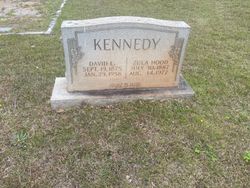
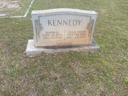
Zula Hood Kennedy
| Birth | : | 30 Jul 1887 South Carolina, USA |
| Death | : | 14 Aug 1977 Pacolet, Spartanburg County, South Carolina, USA |
| Burial | : | Crystal Cemetery, Crystal, Montcalm County, USA |
| Coordinate | : | 43.2347470, -84.9158600 |
| Description | : | Original obituary appears in The Spartanburg Herald Journal Obituary Section on, Monday, Aug. 15, 1977, on page A10. Pacolet, SC - Zula Hood Kennedy died on Sunday, Aug. 14, 1977 in Spartanburg Convalescent Center, following a lengthy illness. Widow of David L. Kennedy. Native of Spartanburg County, SC and daughter of the late Eli and Sara Gossett Hood. Member of the Pacolet United Methodist Church. Survivors included: a number of nieces and nephew. She was 96 years of age at demise and interment was in the Pacolet First Baptist Church Cemetery Cemetery.... Read More |
frequently asked questions (FAQ):
-
Where is Zula Hood Kennedy's memorial?
Zula Hood Kennedy's memorial is located at: Crystal Cemetery, Crystal, Montcalm County, USA.
-
When did Zula Hood Kennedy death?
Zula Hood Kennedy death on 14 Aug 1977 in Pacolet, Spartanburg County, South Carolina, USA
-
Where are the coordinates of the Zula Hood Kennedy's memorial?
Latitude: 43.2347470
Longitude: -84.9158600
Family Members:
Spouse
Flowers:
Nearby Cemetories:
1. Crystal Cemetery
Crystal, Montcalm County, USA
Coordinate: 43.2347470, -84.9158600
2. Burke Cemetery
Carson City, Montcalm County, USA
Coordinate: 43.2196999, -84.8852997
3. Vickeryville Cemetery
Vickeryville, Montcalm County, USA
Coordinate: 43.1917000, -84.9760971
4. Vickeryville Old Order Mennonite Church Cemetery
Vickeryville, Montcalm County, USA
Coordinate: 43.1734880, -84.9342820
5. Carson City Cemetery
Carson City, Montcalm County, USA
Coordinate: 43.1850300, -84.8508400
6. Saint Marys Cemetery
Carson City, Montcalm County, USA
Coordinate: 43.1847600, -84.8508400
7. Spencer Cemetery
Crystal, Montcalm County, USA
Coordinate: 43.2883700, -84.8555700
8. Mount Calm Mennonite Church Cemetery
Carson City, Montcalm County, USA
Coordinate: 43.1801800, -84.8372300
9. Klees Cemetery
Montcalm County, USA
Coordinate: 43.3066340, -84.8607230
10. Bloomer Township Cemetery
Carson City, Montcalm County, USA
Coordinate: 43.1516991, -84.8949966
11. Evergreen Township Cemetery
Sheridan, Montcalm County, USA
Coordinate: 43.2200600, -85.0472300
12. New Haven Township Cemetery
New Haven Center, Gratiot County, USA
Coordinate: 43.2487230, -84.7828580
13. Sumner Cemetery
Sumner, Gratiot County, USA
Coordinate: 43.3139000, -84.8242035
14. Ferris Center Cemetery
Vestaburg, Montcalm County, USA
Coordinate: 43.3438988, -84.9060974
15. Sheridan Cemetery
Sheridan, Montcalm County, USA
Coordinate: 43.2061920, -85.0653030
16. Dalton Cemetery
Carson City, Montcalm County, USA
Coordinate: 43.1202400, -84.9157500
17. Sunny Hill Cemetery
Fenwick, Montcalm County, USA
Coordinate: 43.1319008, -85.0002975
18. Palo Cemetery
Palo, Ionia County, USA
Coordinate: 43.1100000, -84.9380000
19. Roosa Farm Cemetery
Sumner Township, Gratiot County, USA
Coordinate: 43.2922139, -84.7477728
20. Forest Hill Cemetery
Stanton, Montcalm County, USA
Coordinate: 43.2910995, -85.0883026
21. McBride Cemetery
McBride, Montcalm County, USA
Coordinate: 43.3493996, -85.0382996
22. Woodward Cemetery
Hubbardston, Ionia County, USA
Coordinate: 43.0893300, -84.8913600
23. Hubbardston Old Catholic Cemetery
Hubbardston, Ionia County, USA
Coordinate: 43.0908960, -84.8590590
24. Westside Cemetery
Hubbardston, Ionia County, USA
Coordinate: 43.0928001, -84.8506012


