
| Memorials | : | 1 |
| Location | : | Bishop Burton, East Riding of Yorkshire Unitary Authority, England |
| Coordinate | : | 53.8443750, -0.4959940 |
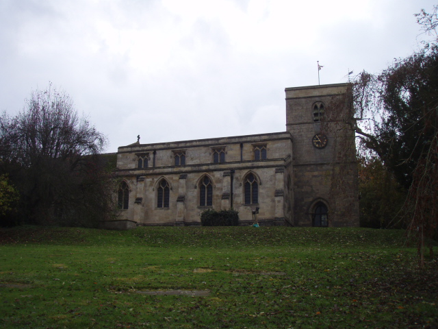
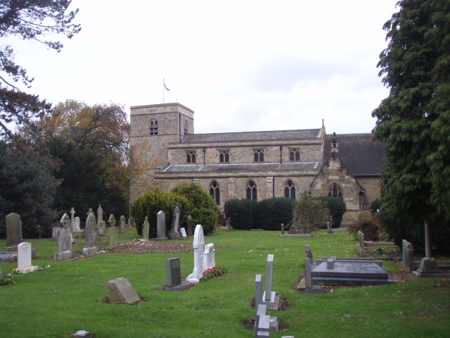
| Description | : | It is believed that there was a Saxon church here in Bishop Burton in the 8th C. that was founded by Earl Pugh and consecrated by St. John of Beverley. It was given to The Dean and Chapter of York in the 12th century and rebuilt in the 14th and 19th centuries. added by Wertypop |
frequently asked questions (FAQ):
-
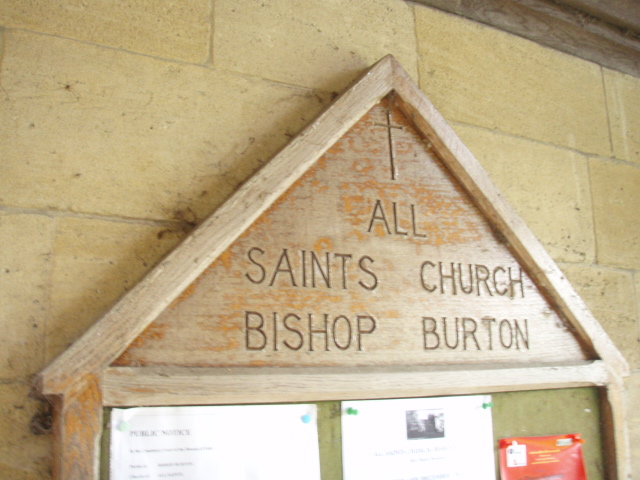
Where is All Saints Churchyard?
All Saints Churchyard is located at Church Lane Bishop Burton, East Riding of Yorkshire Unitary Authority ,East Riding of Yorkshire ,England.
-
All Saints Churchyard cemetery's updated grave count on graveviews.com?
1 memorials
-
Where are the coordinates of the All Saints Churchyard?
Latitude: 53.8443750
Longitude: -0.4959940
Nearby Cemetories:
1. St Michael and All Angels Churchyard
Cherry Burton, East Riding of Yorkshire Unitary Authority, England
Coordinate: 53.8658140, -0.4952220
2. St. Mary's Molescroft Road Cemetery
Beverley, East Riding of Yorkshire Unitary Authority, England
Coordinate: 53.8490070, -0.4421000
3. St Mary Churchyard
Etton, East Riding of Yorkshire Unitary Authority, England
Coordinate: 53.8791000, -0.5086000
4. St. Mary North Bar Within Cemetery
Beverley, East Riding of Yorkshire Unitary Authority, England
Coordinate: 53.8445340, -0.4355770
5. St. Martin's Cemetery
Beverley, East Riding of Yorkshire Unitary Authority, England
Coordinate: 53.8360660, -0.4370590
6. Queensgate Cemetery
Beverley, East Riding of Yorkshire Unitary Authority, England
Coordinate: 53.8314000, -0.4385100
7. St. Mary's Churchyard
Beverley, East Riding of Yorkshire Unitary Authority, England
Coordinate: 53.8440200, -0.4338100
8. St John Cemetery
Beverley, East Riding of Yorkshire Unitary Authority, England
Coordinate: 53.8350750, -0.4354910
9. Beverley Minster Churchyard
Beverley, East Riding of Yorkshire Unitary Authority, England
Coordinate: 53.8389560, -0.4247920
10. St Catherine Churchyard
Leconfield, East Riding of Yorkshire Unitary Authority, England
Coordinate: 53.8800640, -0.4572990
11. St Nicholas Churchyard
Beverley, East Riding of Yorkshire Unitary Authority, England
Coordinate: 53.8411520, -0.4142730
12. St Mary Churchyard
Lockington, East Riding of Yorkshire Unitary Authority, England
Coordinate: 53.9081670, -0.4837860
13. Cottingham Municipal Cemetery
Cottingham, East Riding of Yorkshire Unitary Authority, England
Coordinate: 53.7829540, -0.4307820
14. St Margaret Churchyard
Beswick, East Riding of Yorkshire Unitary Authority, England
Coordinate: 53.9194140, -0.4599290
15. St Mary the Virgin Churchyard
Cottingham, East Riding of Yorkshire Unitary Authority, England
Coordinate: 53.7821910, -0.4117230
16. Priory Woods Cemetery
Cottingham, East Riding of Yorkshire Unitary Authority, England
Coordinate: 53.7748730, -0.4089420
17. All Saints Churchyard
Kilnwick, East Riding of Yorkshire Unitary Authority, England
Coordinate: 53.9320900, -0.4830980
18. Haltemprice Priory
Cottingham, East Riding of Yorkshire Unitary Authority, England
Coordinate: 53.7642860, -0.4207310
19. St Andrew Churchyard
Kirk Ella, East Riding of Yorkshire Unitary Authority, England
Coordinate: 53.7538430, -0.4542050
20. All Saints Churchyard
Goodmanham, East Riding of Yorkshire Unitary Authority, England
Coordinate: 53.8768150, -0.6485010
21. All Saints Churchyard
Brantingham, East Riding of Yorkshire Unitary Authority, England
Coordinate: 53.7585800, -0.5699600
22. St Oswald Churchyard
Hotham, East Riding of Yorkshire Unitary Authority, England
Coordinate: 53.7999020, -0.6434850
23. Mill Lane Cemetery
Kirk Ella, East Riding of Yorkshire Unitary Authority, England
Coordinate: 53.7473720, -0.4519410
24. St. Faith Churchyard
Leven, East Riding of Yorkshire Unitary Authority, England
Coordinate: 53.8943111, -0.3407167