| Memorials | : | 0 |
| Location | : | Glossop, High Peak Borough, England |
| Coordinate | : | 53.4499300, -1.9438570 |
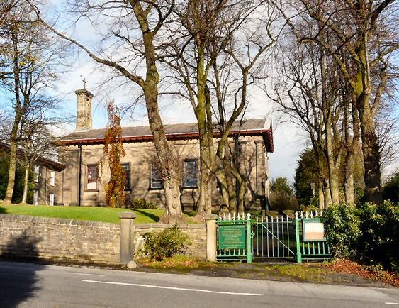
| Description | : | This is the original Catholic church in Glossop, funded by the twelfth Duke of Norfolk and built in 1836. Solidly constructed from stone in the Georgian style. The statue in the church grounds used to be in the convent gardens and was moved to its present position where everybody can see it, When the convent was sold. |
frequently asked questions (FAQ):
-
Where is All Saints RC Churchyard?
All Saints RC Churchyard is located at Royle House, Church Street Glossop, High Peak Borough ,Derbyshire , SK13 7RJEngland.
-
All Saints RC Churchyard cemetery's updated grave count on graveviews.com?
0 memorials
-
Where are the coordinates of the All Saints RC Churchyard?
Latitude: 53.4499300
Longitude: -1.9438570
Nearby Cemetories:
1. All Saints Churchyard
Glossop, High Peak Borough, England
Coordinate: 53.4501340, -1.9386090
2. Glossop Cemetery
Glossop, High Peak Borough, England
Coordinate: 53.4573090, -1.9506990
3. Littlemoor Chapel
Glossop, High Peak Borough, England
Coordinate: 53.4412869, -1.9498293
4. Saint James Churchyard
Whitfield, High Peak Borough, England
Coordinate: 53.4388640, -1.9529100
5. Tintwistle Churchyard
Tintwistle, High Peak Borough, England
Coordinate: 53.4719150, -1.9685915
6. United Reformed Church
Tintwistle, High Peak Borough, England
Coordinate: 53.4729900, -1.9657910
7. St. Mary's Independent Chapel
Charlesworth, High Peak Borough, England
Coordinate: 53.4317127, -1.9856703
8. Hollingworth United Methodist Cemetery
Hollingworth, Metropolitan Borough of Tameside, England
Coordinate: 53.4632891, -1.9958244
9. St. John the Evangelist Churchyard
Charlesworth, High Peak Borough, England
Coordinate: 53.4327430, -1.9945570
10. Mottram Cemetery
Mottram in Longdendale, Metropolitan Borough of Tameside, England
Coordinate: 53.4546420, -2.0086900
11. St. Michael Churchyard
Mottram in Longdendale, Metropolitan Borough of Tameside, England
Coordinate: 53.4544040, -2.0101460
12. St Paul Churchyard
Stalybridge, Metropolitan Borough of Tameside, England
Coordinate: 53.4852000, -2.0440300
13. St. Matthew's Churchyard
Hayfield, High Peak Borough, England
Coordinate: 53.3794310, -1.9461140
14. St Mary's Churchyard
Hyde, Metropolitan Borough of Tameside, England
Coordinate: 53.4652400, -2.0599700
15. Hayfield Cemetery
Hayfield, High Peak Borough, England
Coordinate: 53.3787660, -1.9527010
16. St. John The Baptist Churchyard
Hyde, Metropolitan Borough of Tameside, England
Coordinate: 53.4548411, -2.0644712
17. Holy Trinity Churchyard
Gee Cross, Metropolitan Borough of Tameside, England
Coordinate: 53.4393900, -2.0645500
18. St. Thomas Churchyard
Mellor, Metropolitan Borough of Stockport, England
Coordinate: 53.3970440, -2.0277450
19. St George's Old Churchyard
Stalybridge, Metropolitan Borough of Tameside, England
Coordinate: 53.4844700, -2.0538800
20. Hyde Cemetery
Hyde, Metropolitan Borough of Tameside, England
Coordinate: 53.4437910, -2.0684130
21. Bethel Chapel Chapelyard
Stalybridge, Metropolitan Borough of Tameside, England
Coordinate: 53.4820413, -2.0576195
22. Saint Thomas The Apostle Churchyard
Hyde, Metropolitan Borough of Tameside, England
Coordinate: 53.4509000, -2.0707000
23. Thornsett Cemetery
New Mills, High Peak Borough, England
Coordinate: 53.3777150, -1.9873620
24. St Georges Cemetery
Stalybridge, Metropolitan Borough of Tameside, England
Coordinate: 53.4873400, -2.0576800

