
| Memorials | : | 1 |
| Location | : | Sedalia, Pettis County, USA |
| Coordinate | : | 38.6772100, -93.2011800 |
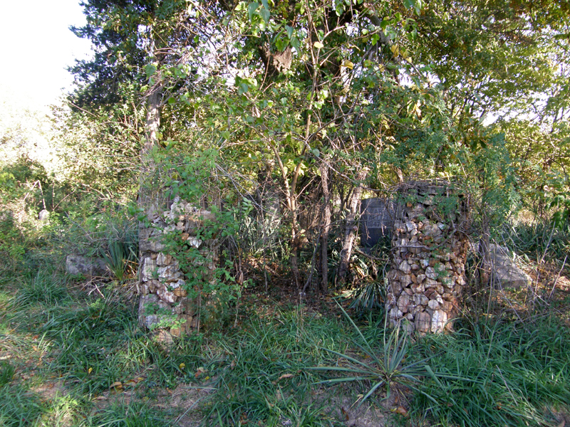
| Description | : | Sedalia Township, Section 14. South on New York Avenue to 40th Street, turn east. Pass Goodwill Chapel Road on the right and then cross a small stream known as Breakfast Brook. A lane will appear on the north side of 40th St. just after passing the branch, take a left into it and go to the end. The cemetery is northeast of a shed structure. If you reach Marshall, you've passed it. This cemetery is on private property and is grown up and not in good shape. There was no sign that I could find, but there were two... Read More |
frequently asked questions (FAQ):
-
Where is Allcorn-Dumsday Cemetery?
Allcorn-Dumsday Cemetery is located at Sedalia, Pettis County ,Missouri ,USA.
-
Allcorn-Dumsday Cemetery cemetery's updated grave count on graveviews.com?
1 memorials
-
Where are the coordinates of the Allcorn-Dumsday Cemetery?
Latitude: 38.6772100
Longitude: -93.2011800
Nearby Cemetories:
1. Highland Sacred Gardens
Sedalia, Pettis County, USA
Coordinate: 38.6831017, -93.1883011
2. Abell Cemetery
Sedalia, Pettis County, USA
Coordinate: 38.6542015, -93.1774979
3. Hebrew Cemetery
Sedalia, Pettis County, USA
Coordinate: 38.6875000, -93.2371979
4. Calvary Episcopal Church Columbarium
Sedalia, Pettis County, USA
Coordinate: 38.7044800, -93.2282100
5. Calvary Cemetery
Sedalia, Pettis County, USA
Coordinate: 38.7170100, -93.2131300
6. Glenwood Cemetery
Sedalia, Pettis County, USA
Coordinate: 38.7163000, -93.2171500
7. Memorial Park Cemetery
Sedalia, Pettis County, USA
Coordinate: 38.6824989, -93.2542038
8. Crown Hill Cemetery
Sedalia, Pettis County, USA
Coordinate: 38.7178001, -93.2149963
9. Pleasant Hill Cemetery
Sedalia, Pettis County, USA
Coordinate: 38.6341600, -93.1817000
10. Asbury Good-Knight Cemetery
Pettis County, USA
Coordinate: 38.6155500, -93.1986100
11. Bethlehem Baptist Church Cemetery
Pettis County, USA
Coordinate: 38.6250000, -93.2457962
12. Flat Creek Baptist Cemetery
Sedalia, Pettis County, USA
Coordinate: 38.6303000, -93.1332800
13. Bourn Cemetery
Spring Fork, Pettis County, USA
Coordinate: 38.6119410, -93.2463310
14. New Bethel Cemetery
Sedalia, Pettis County, USA
Coordinate: 38.6191500, -93.2669600
15. Shobe Cemetery
Sedalia, Pettis County, USA
Coordinate: 38.6996994, -93.2968979
16. Salem Cemetery
Smithton, Pettis County, USA
Coordinate: 38.7352982, -93.1333008
17. Smithton Cemetery
Smithton, Pettis County, USA
Coordinate: 38.6697006, -93.0986023
18. Saint Patricks Catholic Cemetery
Spring Fork, Pettis County, USA
Coordinate: 38.5887300, -93.2137500
19. Georgetown Cemetery
Georgetown, Pettis County, USA
Coordinate: 38.7616770, -93.2398460
20. Lone Star Cemetery
Pettis County, USA
Coordinate: 38.5952988, -93.1382980
21. McKee Chapel Cemetery
Sedalia, Pettis County, USA
Coordinate: 38.6396100, -93.3144800
22. Mount Herman Cemetery
Cedar Township, Pettis County, USA
Coordinate: 38.7748700, -93.2198700
23. Olive Hill Amish Mennonite Cemetery
Beaman, Pettis County, USA
Coordinate: 38.7705600, -93.1413200
24. Wheeler Family Cemetery
Beaman, Pettis County, USA
Coordinate: 38.7533600, -93.1045000