| Memorials | : | 0 |
| Location | : | Paradise Valley, Maricopa County, USA |
| Phone | : | 480-948-6050 |
| Website | : | ascensionparadisevalley.org |
| Coordinate | : | 33.5415180, -111.9350160 |
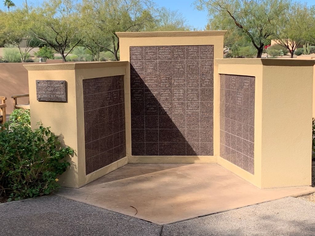
| Description | : | The columbarium is located near the front of the church and is easily accessible from the parking lot. |
frequently asked questions (FAQ):
-
Where is Ascension Lutheran Church Memorial Garden?
Ascension Lutheran Church Memorial Garden is located at 7100 North Mockingbird Lane Paradise Valley, Maricopa County ,Arizona , 85253USA.
-
Ascension Lutheran Church Memorial Garden cemetery's updated grave count on graveviews.com?
0 memorials
-
Where are the coordinates of the Ascension Lutheran Church Memorial Garden?
Latitude: 33.5415180
Longitude: -111.9350160
Nearby Cemetories:
1. Saint Barnabas on the Desert Memorial Garden
Paradise Valley, Maricopa County, USA
Coordinate: 33.5358000, -111.9330000
2. Camelback Cemetery
Paradise Valley, Maricopa County, USA
Coordinate: 33.5243900, -111.9328200
3. Valley Presbyterian Church Memorial Garden
Paradise Valley, Maricopa County, USA
Coordinate: 33.5219000, -111.9311000
4. Chaparral Christian Church Memorial Garden
Maricopa County, USA
Coordinate: 33.5809510, -111.9411110
5. Mountain View Presbyterian Church Memorial Garden
Scottsdale, Maricopa County, USA
Coordinate: 33.5755940, -111.9069290
6. Paradise Valley Methodist Church Columbarium
Paradise Valley, Maricopa County, USA
Coordinate: 33.5302000, -111.9852000
7. Scottsdale United Methodist Church Memorial Garden
Scottsdale, Maricopa County, USA
Coordinate: 33.4967330, -111.9183910
8. Unitarian Universalist Congregation of Phoenix
Paradise Valley, Maricopa County, USA
Coordinate: 33.5313506, -111.9919749
9. Christ Church of the Ascension Memory Garden
Paradise Valley, Maricopa County, USA
Coordinate: 33.5310200, -111.9943900
10. Shepherd of the Hills UCC Memorial Garden
Phoenix, Maricopa County, USA
Coordinate: 33.4950920, -111.9626900
11. North Scottsdale UMC Memorial Garden
Scottsdale, Maricopa County, USA
Coordinate: 33.5928700, -111.9256200
12. Prince of Peace Lutheran Church Columbarium
Phoenix, Maricopa County, USA
Coordinate: 33.4909000, -111.9596330
13. Paradise Memorial Gardens
Scottsdale, Maricopa County, USA
Coordinate: 33.5842018, -111.8796997
14. Saint Francis Catholic Cemetery
Phoenix, Maricopa County, USA
Coordinate: 33.4733009, -111.9738998
15. Alcor Life Extension Foundation
Scottsdale, Maricopa County, USA
Coordinate: 33.6176000, -111.9110000
16. Catholic Church Cemetery
Salt River, Maricopa County, USA
Coordinate: 33.4853210, -111.8686880
17. Papago Park
Phoenix, Maricopa County, USA
Coordinate: 33.4519000, -111.9443000
18. Green Acres Memorial Park
Scottsdale, Maricopa County, USA
Coordinate: 33.4530983, -111.9056015
19. Phoenix Zoo
Phoenix, Maricopa County, USA
Coordinate: 33.4501220, -111.9496530
20. Saint Stephen's Catholic Church and Columbarium
Phoenix, Maricopa County, USA
Coordinate: 33.5563786, -112.0479130
21. Cross Cut Cemetery
Phoenix, Maricopa County, USA
Coordinate: 33.4514370, -111.9794850
22. Taliesin West Burial Site
Scottsdale, Maricopa County, USA
Coordinate: 33.6056130, -111.8457130
23. Hansens Desert Hills Memorial Park and Mortuary
Scottsdale, Maricopa County, USA
Coordinate: 33.6409111, -111.9409332
24. La Casa de Cristo Lutheran Church Memorial Garden
Scottsdale, Maricopa County, USA
Coordinate: 33.6418570, -111.9450960


