
| Memorials | : | 5 |
| Location | : | Atwood, Armstrong County, USA |
| Coordinate | : | 40.7527504, -79.2682037 |
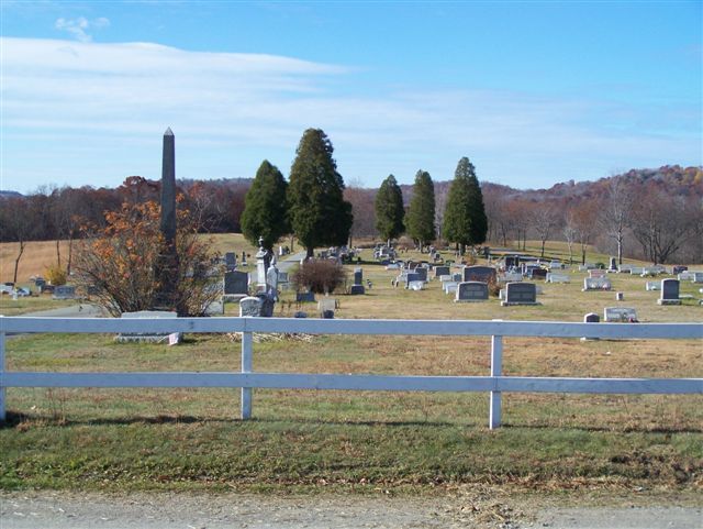
| Description | : | Directions: In Elderton, Armstrong County, Pennsylvania, at the intersection of U.S. Route 422 and Pennsylvania State Route 210, take PA 210 North, for 6.22 miles. You will see the Keystone Lake Boat Launch entrance, on your left. Pass it and take the next right turn onto W. Indiana St., which is between 100 and 200 yards past the Boat Launch entrance. Drive 0.37 miles into the small village of Atwood, PA and take the first right turn onto S. Jefferson St. From this turn, drive 0.15 miles to the cemetery, on the right. There is a section,... Read More |
frequently asked questions (FAQ):
-
Where is Atwood Cemetery?
Atwood Cemetery is located at Atwood, Armstrong County ,Pennsylvania ,USA.
-
Atwood Cemetery cemetery's updated grave count on graveviews.com?
5 memorials
-
Where are the coordinates of the Atwood Cemetery?
Latitude: 40.7527504
Longitude: -79.2682037
Nearby Cemetories:
1. Harmony Grove Cemetery
Indiana County, USA
Coordinate: 40.7318993, -79.2200012
2. Fisher Cemetery
Elderton, Armstrong County, USA
Coordinate: 40.7110610, -79.2780520
3. Bohan Family Farm Burial
Dayton, Armstrong County, USA
Coordinate: 40.7970470, -79.2572490
4. Harkleroad Cemetery
Rural Valley, Armstrong County, USA
Coordinate: 40.7718964, -79.3289719
5. Saint John Lutheran Cemetery
Sagamore, Armstrong County, USA
Coordinate: 40.7858009, -79.2149963
6. Dormition of Saint Mary Cemetery
Beyer, Indiana County, USA
Coordinate: 40.7868780, -79.2149500
7. Sacred Heart Cemetery
Beyer, Indiana County, USA
Coordinate: 40.7877998, -79.2149963
8. Slate Hill Cemetery
Dayton, Armstrong County, USA
Coordinate: 40.7946430, -79.2228310
9. Saint Mary's Cemetery
Kittanning, Armstrong County, USA
Coordinate: 40.7896420, -79.2153120
10. Gastown Cemetery
Gastown, Armstrong County, USA
Coordinate: 40.7081000, -79.3180000
11. Rural Valley Cemetery
Rural Valley, Armstrong County, USA
Coordinate: 40.8019714, -79.3118515
12. Speedy Cemetery
Indiana County, USA
Coordinate: 40.6917000, -79.2425003
13. Saint Paul's Cemetery
Rural Valley, Armstrong County, USA
Coordinate: 40.7620583, -79.3640823
14. Plumville Cemetery
Plumville, Indiana County, USA
Coordinate: 40.7912000, -79.1799000
15. Elderton Presbyterian Church Cemetery
Elderton, Armstrong County, USA
Coordinate: 40.6972520, -79.3432240
16. Kimmel Cemetery
Elderton, Armstrong County, USA
Coordinate: 40.6910190, -79.3346140
17. Sowers Cemetery
Rural Valley, Armstrong County, USA
Coordinate: 40.7775993, -79.3703003
18. Elderton United Methodist Church Cemetery
Elderton, Armstrong County, USA
Coordinate: 40.6941681, -79.3455887
19. Elderton Cemetery
Elderton, Armstrong County, USA
Coordinate: 40.6918000, -79.3436000
20. Schrecengost Farm Cemetery
Armstrong County, USA
Coordinate: 40.8288070, -79.3177450
21. Beracha Presbyterian Church Cemetery
Plumville, Indiana County, USA
Coordinate: 40.7984690, -79.1723190
22. Center Presbyterian Cemetery
Creekside, Indiana County, USA
Coordinate: 40.6849000, -79.1966000
23. Elgin-Old Presbyterian Cemetery
Rural Valley, Armstrong County, USA
Coordinate: 40.8046646, -79.3662949
24. Old Mahoning Baptist Cemetery
South Mahoning Township, Indiana County, USA
Coordinate: 40.8262620, -79.1944240