
| Memorials | : | 0 |
| Location | : | Armstrong County, USA |
| Coordinate | : | 40.8288070, -79.3177450 |
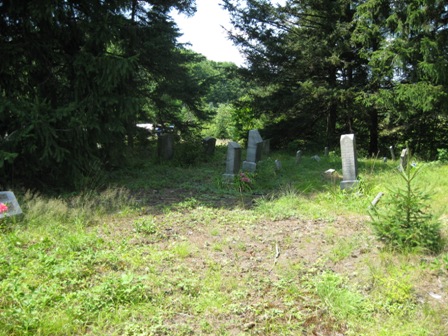
| Description | : | This is a small family cemetery, containing approximately twenty five graves , predominantly of the Schrecengost family. There are three variations of the spelling of this name to be found on the headstones. They are as follows; Schrecengost, Schrecongost and Schrecangost. Presumably they are all of the same family. Driving directions: Beginning at the intersection of SR 1042 (West Main St., Rural Valley Pa.) and SR 1037, also known as Echo Road, turn onto SR 1037 and proceed for approximately 2.3 miles. At this point you will see two houses on your left, and an old weathered barn,... Read More |
frequently asked questions (FAQ):
-
Where is Schrecengost Farm Cemetery?
Schrecengost Farm Cemetery is located at Cowenshannock Township Armstrong County ,Pennsylvania ,USA.
-
Schrecengost Farm Cemetery cemetery's updated grave count on graveviews.com?
0 memorials
-
Where are the coordinates of the Schrecengost Farm Cemetery?
Latitude: 40.8288070
Longitude: -79.3177450

Nearby Cemetories:
1. Pleasant Union Cemetery
Cowanshannock Township, Armstrong County, USA
Coordinate: 40.8314018, -79.3350449
2. Rural Valley Cemetery
Rural Valley, Armstrong County, USA
Coordinate: 40.8019714, -79.3118515
3. Saint Michael's Episcopal Cemetery
Rural Valley, Armstrong County, USA
Coordinate: 40.8542328, -79.3036499
4. Echo Methodist Episcopal Church Cemetery
Armstrong County, USA
Coordinate: 40.8570420, -79.3275330
5. Salem United Church of Christ Cemetery
Kittanning, Armstrong County, USA
Coordinate: 40.8244130, -79.3559970
6. Elgin-Old Presbyterian Cemetery
Rural Valley, Armstrong County, USA
Coordinate: 40.8046646, -79.3662949
7. Calhoun Cemetery
Armstrong County, USA
Coordinate: 40.8502426, -79.3848648
8. Bohan Family Farm Burial
Dayton, Armstrong County, USA
Coordinate: 40.7970470, -79.2572490
9. Harkleroad Cemetery
Rural Valley, Armstrong County, USA
Coordinate: 40.7718964, -79.3289719
10. Concord Presbyterian Church Cemetery
Wayne Township, Armstrong County, USA
Coordinate: 40.8910599, -79.3240356
11. Scott Fox Memorial Site
Kittanning, Armstrong County, USA
Coordinate: 40.8457580, -79.3972170
12. Sowers Cemetery
Rural Valley, Armstrong County, USA
Coordinate: 40.7775993, -79.3703003
13. Belknap Cemetery
Dayton, Armstrong County, USA
Coordinate: 40.8926000, -79.2957000
14. Rehobeth Reformed Presbyterian Church Cemetery
Kittanning, Armstrong County, USA
Coordinate: 40.8922670, -79.3695690
15. Dayton Glade Run Cemetery
Dayton, Armstrong County, USA
Coordinate: 40.8710136, -79.2356262
16. Saint Paul's Cemetery
Rural Valley, Armstrong County, USA
Coordinate: 40.7620583, -79.3640823
17. United Presbyterian Cemetery
Dayton, Armstrong County, USA
Coordinate: 40.8652000, -79.2297000
18. Simpson Church Cemetery
Kittanning, Armstrong County, USA
Coordinate: 40.7899000, -79.4083640
19. Slate Hill Cemetery
Dayton, Armstrong County, USA
Coordinate: 40.7946430, -79.2228310
20. Mount Union Davis Cemetery
Armstrong County, USA
Coordinate: 40.8323850, -79.4236530
21. Atwood Cemetery
Atwood, Armstrong County, USA
Coordinate: 40.7527504, -79.2682037
22. Emory Chapel Memorial Park
Dayton, Armstrong County, USA
Coordinate: 40.8882930, -79.2371320
23. Mount Zion Presbyterian Cemetery
Boggs Township, Armstrong County, USA
Coordinate: 40.8717100, -79.4171980
24. Saint Mary's Cemetery
Kittanning, Armstrong County, USA
Coordinate: 40.7896420, -79.2153120