
| Memorials | : | 3 |
| Location | : | Rockville, Montgomery County, USA |
| Coordinate | : | 39.0897220, -77.1255560 |
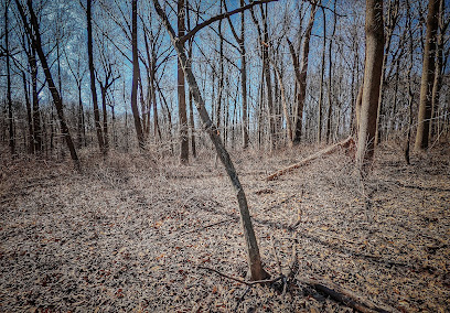
| Description | : | The Avery Road Colored Cemetery is in the woods behind the Croyden Creek Nature Center, going North along the old Avery Road to the Benjamin Smith House Remains located on the West side of the road. The Cemetery is opposite the Benjamin Smith House Remains on the East side of Avery Road, marked on the 1917 map slightly downhill to the South of the House remains. The land is deep in the woods with large oak trees and underbrush. No cemetery fence, signs or markers are visible, and the cemetery only accessible by climbing the ridgeline from Avery Road. Wooden... Read More |
frequently asked questions (FAQ):
-
Where is Avery Road Colored Cemetery?
Avery Road Colored Cemetery is located at Rockville, Montgomery County ,Maryland ,USA.
-
Avery Road Colored Cemetery cemetery's updated grave count on graveviews.com?
3 memorials
-
Where are the coordinates of the Avery Road Colored Cemetery?
Latitude: 39.0897220
Longitude: -77.1255560
Nearby Cemetories:
1. Rockville Cemetery
Rockville, Montgomery County, USA
Coordinate: 39.0844002, -77.1260986
2. New Saint Mary's Catholic Church Cemetery
Rockville, Montgomery County, USA
Coordinate: 39.0830994, -77.1268997
3. Rockville United Church Memorial Garden
Rockville, Montgomery County, USA
Coordinate: 39.0783570, -77.1158440
4. Martin Family Cemetery
Rockville, Montgomery County, USA
Coordinate: 39.0960100, -77.1428960
5. Lincoln Park Cemetery
Rockville, Montgomery County, USA
Coordinate: 39.0954300, -77.1452900
6. Old Saint Mary's Catholic Church Cemetery
Rockville, Montgomery County, USA
Coordinate: 39.0819830, -77.1453850
7. Christ Episcopal Church Columbarium
Rockville, Montgomery County, USA
Coordinate: 39.0823100, -77.1528500
8. Rockville United Methodist Church Columbarium
Rockville, Montgomery County, USA
Coordinate: 39.0839060, -77.1554180
9. Rockville Baptist Cemetery
Rockville, Montgomery County, USA
Coordinate: 39.0835400, -77.1562300
10. Haiti Cemetery
Rockville, Montgomery County, USA
Coordinate: 39.0931000, -77.1573100
11. Prather Family Cemetery
Montgomery County, USA
Coordinate: 39.1133330, -77.1147220
12. Montgomery County Poor Farm Cemetery
Rockville, Montgomery County, USA
Coordinate: 39.0727400, -77.1540500
13. Parklawn Memorial Park and Menorah Gardens
Rockville, Montgomery County, USA
Coordinate: 39.0639000, -77.1091995
14. Higgins Family Cemetery
Rockville, Montgomery County, USA
Coordinate: 39.0597400, -77.1162300
15. Crabb Family Cemetery
Derwood, Montgomery County, USA
Coordinate: 39.1151300, -77.1582400
16. Faith United Methodist Church Memorial Garden
Rockville, Montgomery County, USA
Coordinate: 39.0536300, -77.1392600
17. Derwood Cemetery
Derwood, Montgomery County, USA
Coordinate: 39.1186400, -77.1580800
18. Aspin Hill Memorial Park
Silver Spring, Montgomery County, USA
Coordinate: 39.0799600, -77.0772300
19. Mount Pleasant Methodist Church Cemetery
Norbeck, Montgomery County, USA
Coordinate: 39.1104800, -77.0810960
20. Gate of Heaven Cemetery
Silver Spring, Montgomery County, USA
Coordinate: 39.0825005, -77.0738983
21. Saint Lukes Lutheran Cemetery
Derwood, Montgomery County, USA
Coordinate: 39.1304800, -77.1494800
22. Beall Cemetery
Silver Spring, Montgomery County, USA
Coordinate: 39.0877991, -77.0607986
23. Trinity Lutheran Church Columbarium
Rockville, Montgomery County, USA
Coordinate: 39.0387727, -77.1235788
24. Owen Family Cemetery
Olney, Montgomery County, USA
Coordinate: 39.1362800, -77.0969200