
| Memorials | : | 0 |
| Location | : | Rawdon, Metropolitan Borough of Leeds, England |
| Coordinate | : | 53.8576300, -1.6881400 |
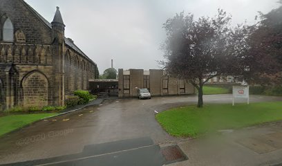
| Description | : | The site for this church and graveyard was originally within the grounds of Benton Park. It was donated by Robert Milligan, first Mayor of Bradford and Member of Parliament, who lived at Benton Park. The church opened in 1846 and was enlarged in 1868. Just over a century later in 1972, the Congregational, Baptist and Methodist Churches of Rawdon combined to become one congregation. Their place of worship, Trinity Church, is located in the original Benton Congregational Chapel. The surrounding graveyard has been leveled and covered in grass. |
frequently asked questions (FAQ):
-
Where is Benton Park Congregational Chapelyard?
Benton Park Congregational Chapelyard is located at New Road Side, Green Lane Rawdon, Metropolitan Borough of Leeds ,West Yorkshire , LS19 6DDEngland.
-
Benton Park Congregational Chapelyard cemetery's updated grave count on graveviews.com?
0 memorials
-
Where are the coordinates of the Benton Park Congregational Chapelyard?
Latitude: 53.8576300
Longitude: -1.6881400
Nearby Cemetories:
1. Friends Burial Ground
Rawdon, Metropolitan Borough of Leeds, England
Coordinate: 53.8562540, -1.6856120
2. St John the Evangelist Churchyard
Yeadon, Metropolitan Borough of Leeds, England
Coordinate: 53.8610120, -1.6908590
3. Cragg Baptist Chapelyard
Rawdon, Metropolitan Borough of Leeds, England
Coordinate: 53.8517260, -1.6919510
4. Wesleyan Burial Ground
Yeadon, Metropolitan Borough of Leeds, England
Coordinate: 53.8655770, -1.6852220
5. Greenhill Wesleyan Methodist Chapelyard
Rawdon, Metropolitan Borough of Leeds, England
Coordinate: 53.8503020, -1.6771360
6. Cragg Wood Baptist Burial Ground
Rawdon, Metropolitan Borough of Leeds, England
Coordinate: 53.8453830, -1.6898020
7. Friends Burial Ground
Yeadon, Metropolitan Borough of Leeds, England
Coordinate: 53.8659722, -1.7047778
8. St. Peter's Churchyard
Rawdon, Metropolitan Borough of Leeds, England
Coordinate: 53.8486800, -1.6658000
9. Yeadon Cemetery
Yeadon, Metropolitan Borough of Leeds, England
Coordinate: 53.8716080, -1.6751690
10. Esholt Priory
Esholt, Metropolitan Borough of Bradford, England
Coordinate: 53.8529000, -1.7143700
11. St. Oswald's Churchyard
Guiseley, Metropolitan Borough of Leeds, England
Coordinate: 53.8751330, -1.7062080
12. Guiseley Primitive Methodist Chapelyard
Guiseley, Metropolitan Borough of Leeds, England
Coordinate: 53.8733790, -1.7119970
13. St Paul Churchyard
Esholt, Metropolitan Borough of Bradford, England
Coordinate: 53.8571100, -1.7240300
14. Rawdon Crematorium
Rawdon, Metropolitan Borough of Leeds, England
Coordinate: 53.8401170, -1.6628580
15. St. Wilfrid Churchyard
Calverley, Metropolitan Borough of Leeds, England
Coordinate: 53.8303600, -1.6849920
16. Thorpe Wesleyan Methodist Cemetery
Idle, Metropolitan Borough of Bradford, England
Coordinate: 53.8350900, -1.7259800
17. Holy Trinity Churchyard
Idle, Metropolitan Borough of Bradford, England
Coordinate: 53.8380900, -1.7318300
18. Horsforth Cemetery
Horsforth, Metropolitan Borough of Leeds, England
Coordinate: 53.8334500, -1.6516100
19. Guiseley Cemetery
Guiseley, Metropolitan Borough of Leeds, England
Coordinate: 53.8846820, -1.7192470
20. Thorpe Wesleyan Methodist Chapelyard
Idle, Metropolitan Borough of Bradford, England
Coordinate: 53.8343600, -1.7280700
21. St Margaret's Burial Ground
Horsforth, Metropolitan Borough of Leeds, England
Coordinate: 53.8376300, -1.6428400
22. Horsforth Peace Gardens
Horsforth, Metropolitan Borough of Leeds, England
Coordinate: 53.8364395, -1.6430796
23. Upper Chapel Congregational Old Cemetery
Idle, Metropolitan Borough of Bradford, England
Coordinate: 53.8374500, -1.7355600
24. Upper Chapel Congregational Chapelyard
Idle, Metropolitan Borough of Bradford, England
Coordinate: 53.8371300, -1.7353800