
| Memorials | : | 186 |
| Location | : | Kings Walden, North Hertfordshire District, England |
| Coordinate | : | 51.8843200, -0.3293700 |
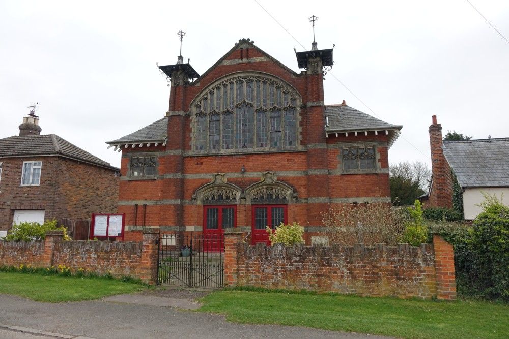
| Description | : | Breachwood Green is a large hamlet that is located between Kings Walden and Luton Airport's runway. This Baptist chapel by George Baines and Sons dating from 1904 is the only place of worship in Breachwood Green as the parish church is located in Kings Walden. It replaced an older 1870s building, whose schoolrooms remain at the rear. It also contains a much older pulpit reputed to be that used by John Bunyan in the late 17th century. |
frequently asked questions (FAQ):
-
Where is Breachwood Green Baptist Church?
Breachwood Green Baptist Church is located at 25 Chapel Rd, Breachwood Green, Hitchin Kings Walden, North Hertfordshire District ,Hertfordshire , SG4 8NXEngland.
-
Breachwood Green Baptist Church cemetery's updated grave count on graveviews.com?
186 memorials
-
Where are the coordinates of the Breachwood Green Baptist Church?
Latitude: 51.8843200
Longitude: -0.3293700
Nearby Cemetories:
1. St Martins
Preston, North Hertfordshire District, England
Coordinate: 51.9091932, -0.2876494
2. All Saints Churchyard
St Pauls Walden, North Hertfordshire District, England
Coordinate: 51.8865400, -0.2689200
3. Ss Peter and Paul Churchyard
Kimpton, North Hertfordshire District, England
Coordinate: 51.8527990, -0.2918240
4. Luton Vauxhall Motors War Memorial
Luton, Luton Borough, England
Coordinate: 51.8745100, -0.3967500
5. St Mary Magdalene Churchyard
Offley, North Hertfordshire District, England
Coordinate: 51.9277300, -0.3357400
6. Vale Cemetery and Crematorium
Luton, Luton Borough, England
Coordinate: 51.9070900, -0.3924930
7. Quaker Burial Ground
Luton, Luton Borough, England
Coordinate: 51.8791910, -0.4023320
8. Church Burial Ground
Luton, Luton Borough, England
Coordinate: 51.8794640, -0.4027310
9. Holy Trinity Churchyard
East Hyde, Central Bedfordshire Unitary Authority, England
Coordinate: 51.8433710, -0.3640760
10. Minsden Chapel
Hitchin, North Hertfordshire District, England
Coordinate: 51.9069200, -0.2595700
11. St. Mary's Churchyard
Luton, Luton Borough, England
Coordinate: 51.8788681, -0.4100020
12. Friend's Burial Ground
Luton, Luton Borough, England
Coordinate: 51.8738060, -0.4170870
13. National Children's Home Cemetery
Harpenden, St Albans District, England
Coordinate: 51.8305000, -0.3563000
14. St Lawrence Churchyard
Ayot St Lawrence, Welwyn Hatfield District, England
Coordinate: 51.8379490, -0.2717340
15. Luton General Cemetery
Luton, Luton Borough, England
Coordinate: 51.8773780, -0.4242060
16. Westfield Road Cemetery
Harpenden, St Albans District, England
Coordinate: 51.8270720, -0.3540300
17. Ayot St Lawrence Old Churchyard
Ayot St Lawrence, Welwyn Hatfield District, England
Coordinate: 51.8377038, -0.2678795
18. St Ippolyts Church
St Ippolyts, North Hertfordshire District, England
Coordinate: 51.9298460, -0.2591680
19. St Andrew Woodside Churchyard
Slip End, Central Bedfordshire Unitary Authority, England
Coordinate: 51.8577160, -0.4306600
20. Hitchin Cemetery
Hitchin, North Hertfordshire District, England
Coordinate: 51.9429090, -0.2732690
21. Holy Trinity Churchyard
Biscot, Luton Borough, England
Coordinate: 51.9028700, -0.4375560
22. St Nicholas Churchyard
Harpenden, St Albans District, England
Coordinate: 51.8169470, -0.3583300
23. St. Mary's Churchyard
Knebworth, North Hertfordshire District, England
Coordinate: 51.8723580, -0.2160890
24. St. Helen's Churchyard
Wheathampstead, St Albans District, England
Coordinate: 51.8124510, -0.2946400