
| Memorials | : | 1 |
| Location | : | Luton, Luton Borough, England |
| Coordinate | : | 51.8745100, -0.3967500 |
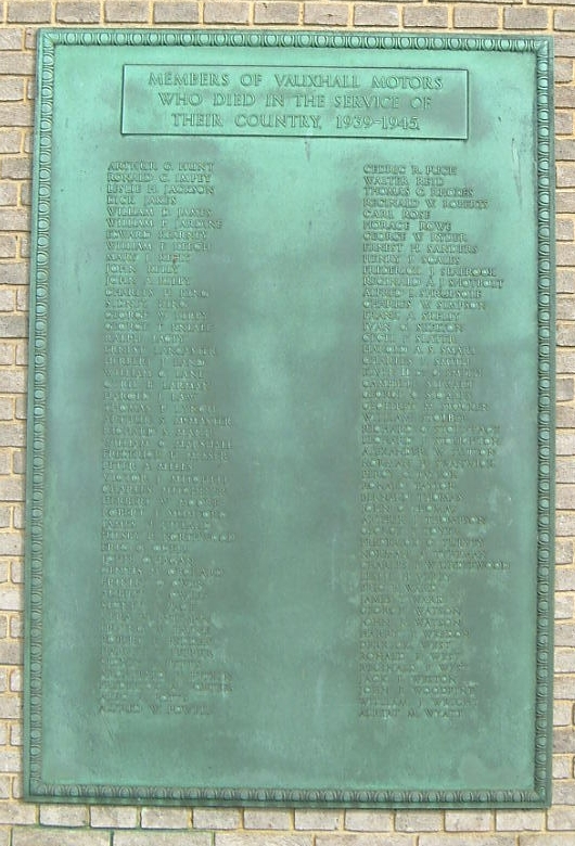
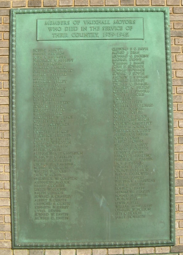
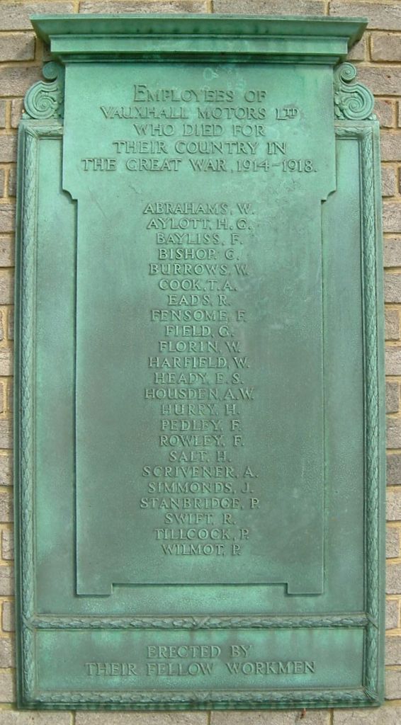
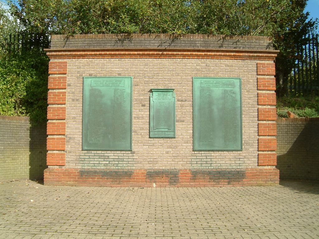
| Description | : | A War Memorial for employees of Vauxhall Motors Ltd in Luton who died as a result of the wars in 1914-1918 and 1939-1945. |
frequently asked questions (FAQ):
-
Where is Luton Vauxhall Motors War Memorial?
Luton Vauxhall Motors War Memorial is located at Kimpton Road (A505) Luton, Luton Borough ,Bedfordshire , LU2England.
-
Luton Vauxhall Motors War Memorial cemetery's updated grave count on graveviews.com?
1 memorials
-
Where are the coordinates of the Luton Vauxhall Motors War Memorial?
Latitude: 51.8745100
Longitude: -0.3967500
Nearby Cemetories:
1. Quaker Burial Ground
Luton, Luton Borough, England
Coordinate: 51.8791910, -0.4023320
2. Church Burial Ground
Luton, Luton Borough, England
Coordinate: 51.8794640, -0.4027310
3. St. Mary's Churchyard
Luton, Luton Borough, England
Coordinate: 51.8788681, -0.4100020
4. Friend's Burial Ground
Luton, Luton Borough, England
Coordinate: 51.8738060, -0.4170870
5. Luton General Cemetery
Luton, Luton Borough, England
Coordinate: 51.8773780, -0.4242060
6. St Andrew Woodside Churchyard
Slip End, Central Bedfordshire Unitary Authority, England
Coordinate: 51.8577160, -0.4306600
7. Vale Cemetery and Crematorium
Luton, Luton Borough, England
Coordinate: 51.9070900, -0.3924930
8. Holy Trinity Churchyard
East Hyde, Central Bedfordshire Unitary Authority, England
Coordinate: 51.8433710, -0.3640760
9. All Saints Churchyard
Caddington, Central Bedfordshire Unitary Authority, England
Coordinate: 51.8670460, -0.4561910
10. Holy Trinity Churchyard
Biscot, Luton Borough, England
Coordinate: 51.9028700, -0.4375560
11. Aley Green Cemetery
Slip End, Central Bedfordshire Unitary Authority, England
Coordinate: 51.8522500, -0.4496420
12. Breachwood Green Baptist Church
Kings Walden, North Hertfordshire District, England
Coordinate: 51.8843200, -0.3293700
13. National Children's Home Cemetery
Harpenden, St Albans District, England
Coordinate: 51.8305000, -0.3563000
14. Westfield Road Cemetery
Harpenden, St Albans District, England
Coordinate: 51.8270720, -0.3540300
15. St. John the Baptist Churchyard
Markyate, Dacorum Borough, England
Coordinate: 51.8391900, -0.4658200
16. St. Leonard's Churchyard
Flamstead, Dacorum Borough, England
Coordinate: 51.8199400, -0.4326800
17. St. Giles in the Woods Priory
Flamstead, Dacorum Borough, England
Coordinate: 51.8187400, -0.4374400
18. St Nicholas Churchyard
Harpenden, St Albans District, England
Coordinate: 51.8169470, -0.3583300
19. St Mary Magdalene Churchyard
Offley, North Hertfordshire District, England
Coordinate: 51.9277300, -0.3357400
20. St Mary the Virgin, Kensworth
Kensworth, Central Bedfordshire Unitary Authority, England
Coordinate: 51.8602233, -0.5037911
21. Ss Peter and Paul Churchyard
Kimpton, North Hertfordshire District, England
Coordinate: 51.8527990, -0.2918240
22. St. Mary the Virgin Churchyard
Sundon, Central Bedfordshire Unitary Authority, England
Coordinate: 51.9301970, -0.4769740
23. Dunstable Priory
Dunstable, Central Bedfordshire Unitary Authority, England
Coordinate: 51.8859940, -0.5177920
24. St Martins
Preston, North Hertfordshire District, England
Coordinate: 51.9091932, -0.2876494