
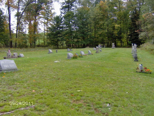
| Memorials | : | 2 |
| Location | : | Markton, Jefferson County, USA |
| Coordinate | : | 41.0175000, -79.0575000 |
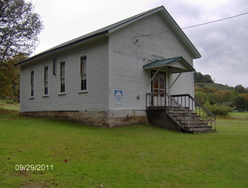
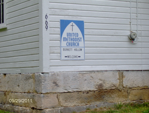
| Description | : | Burkett Hollow Cemetery lies behind the United Methodist Church of Burkett Hollow, which is no longer being used for services. It is located in Oliver Township; 1/2 mile Northeast of the village of Markton, in Jefferson Co., PA. |
frequently asked questions (FAQ):
-
Where is Burkett Hollow Cemetery?
Burkett Hollow Cemetery is located at Burkett Hollow Road (County Road 3011) Markton, Jefferson County ,Pennsylvania ,USA.
-
Burkett Hollow Cemetery cemetery's updated grave count on graveviews.com?
2 memorials
-
Where are the coordinates of the Burkett Hollow Cemetery?
Latitude: 41.0175000
Longitude: -79.0575000
Nearby Cemetories:
1. Markton Cemetery
Markton, Jefferson County, USA
Coordinate: 41.0101000, -79.0605000
2. Saint Pauls Lutheran Cemetery
Coolspring, Jefferson County, USA
Coordinate: 41.0328170, -79.0810670
3. Coolspring Cemetery
Coolspring, Jefferson County, USA
Coordinate: 41.0339012, -79.0847015
4. Olive Cemetery
Oliveburg, Jefferson County, USA
Coordinate: 40.9940000, -79.0270000
5. Barton Chapel Cemetery
Sprankle Mills, Jefferson County, USA
Coordinate: 41.0026054, -79.0983047
6. Mauk Cemetery
Jefferson County, USA
Coordinate: 41.0241600, -79.1097200
7. Mount Tabor United Methodist Church Cemetery
Battle Hollow, Jefferson County, USA
Coordinate: 41.0030000, -78.9970000
8. Saint Matthews Evangelical Lutheran Cemetery
Ramsaytown, Jefferson County, USA
Coordinate: 41.0742600, -79.0574100
9. Hopewell United Methodist Church Cemetery
Frostburg, Jefferson County, USA
Coordinate: 40.9620000, -79.0393000
10. Grange Church of God Cemetery
Grange, Jefferson County, USA
Coordinate: 40.9647170, -79.0876330
11. Perry Memorial Cemetery
Frostburg, Jefferson County, USA
Coordinate: 40.9599991, -79.0635986
12. Old Ebenezer Cemetery
Jefferson County, USA
Coordinate: 40.9846000, -79.1208600
13. Saint Johns Reformed UCC Cemetery
Jefferson County, USA
Coordinate: 40.9810000, -79.1180000
14. Adrian-Anita Roman Catholic Cemetery
Anita, Jefferson County, USA
Coordinate: 40.9958000, -78.9805984
15. Worthville Cemetery
Worthville, Jefferson County, USA
Coordinate: 41.0207062, -79.1404419
16. Cliff United Methodist Church Cemetery
Langville, Jefferson County, USA
Coordinate: 41.0545000, -79.1246000
17. Anita Cemetery
Anita, Jefferson County, USA
Coordinate: 40.9972500, -78.9770700
18. Anita Community Cemetery
Anita, Jefferson County, USA
Coordinate: 40.9932450, -78.9790390
19. Ramsaytown United Methodist Cemetery
Ramsaytown, Jefferson County, USA
Coordinate: 41.0799000, -79.0792000
20. Center Hill Cemetery
Jefferson County, USA
Coordinate: 41.0705185, -79.0066376
21. Beaver Run Cemetery
Stanton, Jefferson County, USA
Coordinate: 41.0734634, -79.1145248
22. Minteer-McClatchy Burial Site
Worthville, Jefferson County, USA
Coordinate: 41.0291250, -79.1503140
23. Saint Jacob Cemetery
Jefferson County, USA
Coordinate: 40.9461900, -79.0987400
24. Knoxdale Mount Pleasant Cemetery
Knox Dale, Jefferson County, USA
Coordinate: 41.0911903, -79.0241013