
| Memorials | : | 4 |
| Location | : | Burnt Factory, Frederick County, USA |
| Phone | : | 540-667-4993 |
| Website | : | www.gbgm-umc.org/burntfactory/ |
| Coordinate | : | 39.1949005, -78.0755005 |
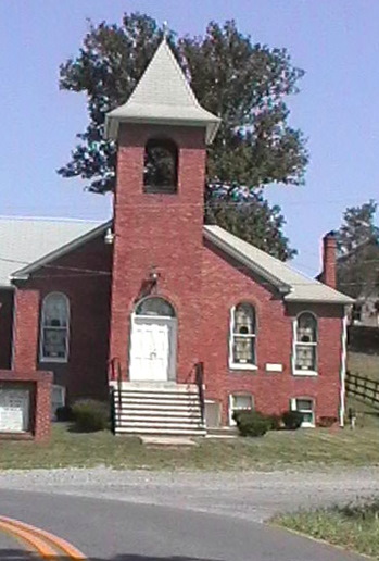
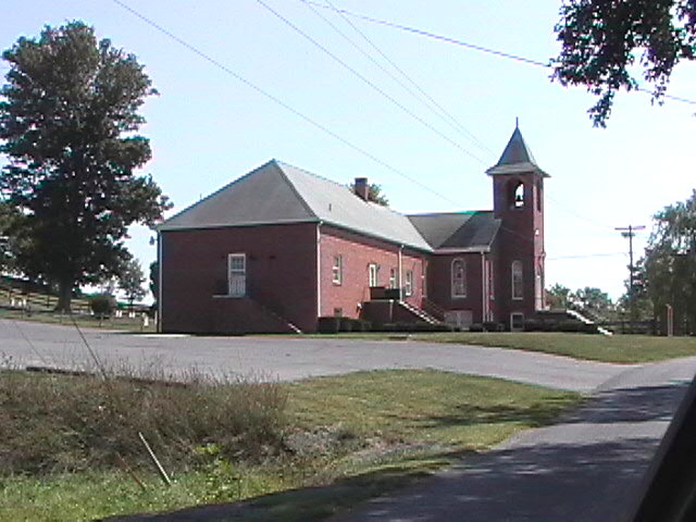
| Description | : | Mailing Address: PO Box 399 Stephenson, Virginia 22656 In February of 1826 Jesse Calvert deeded land "for a place to preach and espouse the word of God." Much of the land in the area was owned by Joseph Carter whose son, James, ran a paper mill located near where the church stood. The mill was converted into a wool mill which later burned, giving the name of "Burnt Factory" to the area. On April 8th, 1925 the original church was torn down and the lumber sold at public auction in May to generate funds for a... Read More |
frequently asked questions (FAQ):
-
Where is Burnt Factory United Methodist Church Cemetery?
Burnt Factory United Methodist Church Cemetery is located at 1943 Jordan Springs Road Burnt Factory, Frederick County ,Virginia , 22656USA.
-
Burnt Factory United Methodist Church Cemetery cemetery's updated grave count on graveviews.com?
4 memorials
-
Where are the coordinates of the Burnt Factory United Methodist Church Cemetery?
Latitude: 39.1949005
Longitude: -78.0755005

Nearby Cemetories:
1. Redbud Cemetery
Burnt Factory, Frederick County, USA
Coordinate: 39.1918983, -78.0916977
2. Redbud United Methodist Church Cemetery
Frederick County, USA
Coordinate: 39.1925000, -78.1019400
3. Milburn Methodist Chapel Cemetery
Stephenson, Frederick County, USA
Coordinate: 39.2235985, -78.1136017
4. Greenwood United Methodist Church Cemetery
Greenwood Heights, Frederick County, USA
Coordinate: 39.1719017, -78.1222000
5. Russell Family Cemetery Rock Hall
Berryville, Clarke County, USA
Coordinate: 39.1748210, -78.0211690
6. Kitchen-Gaunt Family Cemetery
Longmarsh Acres, Clarke County, USA
Coordinate: 39.1729300, -78.0180500
7. Jabbers Hill Cemetery
Clear Brook, Frederick County, USA
Coordinate: 39.2472000, -78.0505981
8. Brucetown United Methodist Church Cemetery
Clear Brook, Frederick County, USA
Coordinate: 39.2524986, -78.0606003
9. Crums Cemetery
Berryville, Clarke County, USA
Coordinate: 39.2092018, -78.0018997
10. Stones Chapel Cemetery
Clarke County, USA
Coordinate: 39.2261009, -78.0105972
11. Salem Regular Baptist Church Cemetery
Boyce, Clarke County, USA
Coordinate: 39.1300011, -78.0828018
12. Carpers Valley Cemetery
Frederick County, USA
Coordinate: 39.1315260, -78.1088900
13. Hopewell Friends Burial Ground
Clear Brook, Frederick County, USA
Coordinate: 39.2564011, -78.1147003
14. Thomas Blakemore Family Farm Cemetery
Berryville, Clarke County, USA
Coordinate: 39.1724620, -77.9900770
15. Grace Bible Fellowship Cemetery
Clear Brook, Frederick County, USA
Coordinate: 39.2643747, -78.0620388
16. Welltown United Methodist Church Cemetery
Welltown, Frederick County, USA
Coordinate: 39.2532997, -78.1333008
17. Westminster-Canterbury Memorial Gardens
Frederick County, USA
Coordinate: 39.2021010, -78.1750927
18. Jamestown Cemetery
Summit Point, Jefferson County, USA
Coordinate: 39.2346800, -77.9842300
19. Galilee Christian Church Cemetery
Clear Brook, Frederick County, USA
Coordinate: 39.2640991, -78.1341019
20. Berryville Baptist Church Cemetery
Berryville, Clarke County, USA
Coordinate: 39.1534060, -77.9826350
21. Prosperity Baptist Church Cemetery
Summit Point, Jefferson County, USA
Coordinate: 39.2387730, -77.9843590
22. AME Church Cemetery
Berryville, Clarke County, USA
Coordinate: 39.1541940, -77.9803560
23. Green Hill Cemetery
Berryville, Clarke County, USA
Coordinate: 39.1581001, -77.9768982
24. Grace Episcopal Church Cemetery
Berryville, Clarke County, USA
Coordinate: 39.1524390, -77.9800680