
| Memorials | : | 0 |
| Location | : | Chester, Cheshire West and Chester Unitary Authority, England |
| Coordinate | : | 53.1853170, -2.8927920 |
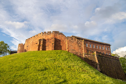
| Description | : | Founded by William I in 1070. The castle was used as a gaol by 1241, when Welsh hostages were confined there. By the 16th century the county gaol was situated in the outer gatehouse and the adjoining former exchequer. It became a detention centre for recusants in the 1580s and 1590s. In 1648, it was refurbished and restored to use after the discovery of a royalist plot to recover castle and city. By 1681 the prison was in great decay. Although the Crown met the heavy costs of renovation, thereafter its maintenance was left to the county authorities,... Read More |
frequently asked questions (FAQ):
-
Where is Chester Castle Cemetery?
Chester Castle Cemetery is located at Chester, Cheshire West and Chester Unitary Authority ,Cheshire ,England.
-
Chester Castle Cemetery cemetery's updated grave count on graveviews.com?
0 memorials
-
Where are the coordinates of the Chester Castle Cemetery?
Latitude: 53.1853170
Longitude: -2.8927920
Nearby Cemetories:
1. St. Mary's Centre
Chester, Cheshire West and Chester Unitary Authority, England
Coordinate: 53.1868400, -2.8917900
2. St Bridget Churchyard
Chester, Cheshire West and Chester Unitary Authority, England
Coordinate: 53.1871000, -2.8931900
3. St. Mary Without-The-Walls Churchyard
Chester, Cheshire West and Chester Unitary Authority, England
Coordinate: 53.1828358, -2.8888967
4. Overleigh Old Cemetery
Chester, Cheshire West and Chester Unitary Authority, England
Coordinate: 53.1808930, -2.8936610
5. St Peter's Church
Chester, Cheshire West and Chester Unitary Authority, England
Coordinate: 53.1903000, -2.8917200
6. Overleigh New Cemetery
Chester, Cheshire West and Chester Unitary Authority, England
Coordinate: 53.1801900, -2.8941500
7. Wesleyan Chapel
Chester, Cheshire West and Chester Unitary Authority, England
Coordinate: 53.1898540, -2.8883230
8. Saint John the Baptist Churchyard
Chester, Cheshire West and Chester Unitary Authority, England
Coordinate: 53.1888299, -2.8855186
9. Chester City Gaol Cemetery
Chester, Cheshire West and Chester Unitary Authority, England
Coordinate: 53.1916040, -2.8962990
10. Chester Cathedral
Chester, Cheshire West and Chester Unitary Authority, England
Coordinate: 53.1918900, -2.8904600
11. Catholic Apostolic Church
Chester, Cheshire West and Chester Unitary Authority, England
Coordinate: 53.1950660, -2.8949290
12. Chester Crematorium
Chester, Cheshire West and Chester Unitary Authority, England
Coordinate: 53.2050100, -2.9065700
13. Blacon Cemetery
Chester, Cheshire West and Chester Unitary Authority, England
Coordinate: 53.2053200, -2.9106300
14. St Mary the Virgin Churchyard
Eccleston, Cheshire West and Chester Unitary Authority, England
Coordinate: 53.1570100, -2.8792600
15. Holy Ascension Churchyard
Upton-by-Chester, Cheshire West and Chester Unitary Authority, England
Coordinate: 53.2157300, -2.8878700
16. St James Churchyard
Christleton, Cheshire West and Chester Unitary Authority, England
Coordinate: 53.1854400, -2.8382800
17. St. John the Baptist Churchyard
Guilden Sutton, Cheshire West and Chester Unitary Authority, England
Coordinate: 53.2077400, -2.8263600
18. Mickle Trafford Methodist Church Cemetery
Chester, Cheshire West and Chester Unitary Authority, England
Coordinate: 53.2210040, -2.8327861
19. Saughall Churches of Christ Grove Chapel
Saughall, Cheshire West and Chester Unitary Authority, England
Coordinate: 53.2218900, -2.9583300
20. St Oswalds Churchyard
Backford, Cheshire West and Chester Unitary Authority, England
Coordinate: 53.2387200, -2.9034100
21. Ebenezer Primitive Methodist Churchyard
Saughall, Cheshire West and Chester Unitary Authority, England
Coordinate: 53.2232500, -2.9574500
22. St Mary Churchyard
Bruera, Cheshire West and Chester Unitary Authority, England
Coordinate: 53.1390980, -2.8420290
23. St Peter Churchyard
Waverton, Cheshire West and Chester Unitary Authority, England
Coordinate: 53.1645900, -2.8065200
24. All Saints Churchyard
Saughall, Cheshire West and Chester Unitary Authority, England
Coordinate: 53.2271271, -2.9550779