
| Memorials | : | 5 |
| Location | : | Chesterville, Morrow County, USA |
| Coordinate | : | 40.4798000, -82.6799780 |
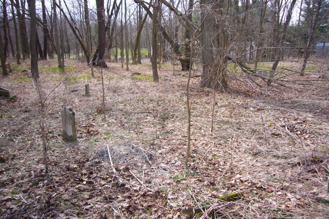
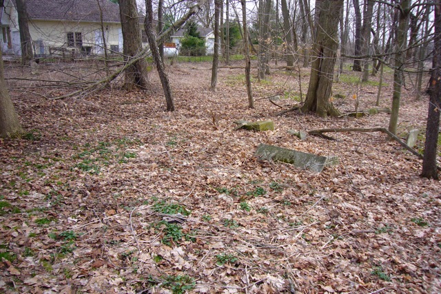
| Description | : | This abandoned cemetery is located south of East Sandusky Street (Ohio State Route 95) and west of Chesterville-Shelby Road (Ohio State Route 314). The cemetery is 0.81 acres in size. The cemetery is located in Chester Township, Morrow County, Ohio, and is # 8627 (Chesterville Presbyterian Cemetery) in “Ohio Cemeteries 1803-2003”, compiled by the Ohio Genealogical Society. |
frequently asked questions (FAQ):
-
Where is Chesterville Presbyterian Cemetery?
Chesterville Presbyterian Cemetery is located at Chesterville-Shelby Road (Ohio State Route 314) Chesterville, Morrow County ,Ohio , 43317USA.
-
Chesterville Presbyterian Cemetery cemetery's updated grave count on graveviews.com?
5 memorials
-
Where are the coordinates of the Chesterville Presbyterian Cemetery?
Latitude: 40.4798000
Longitude: -82.6799780
Nearby Cemetories:
1. Chesterville Methodist Episcopal Cemetery
Chesterville, Morrow County, USA
Coordinate: 40.4798000, -82.6799780
2. Maple Grove Cemetery
Chesterville, Morrow County, USA
Coordinate: 40.4761009, -82.6782990
3. Center Corners Cemetery
Chesterville, Morrow County, USA
Coordinate: 40.5030000, -82.6725600
4. Chester Baptist Cemetery
Morrow County, USA
Coordinate: 40.4483900, -82.6979500
5. Yankee Street Presbyterian Cemetery
Chesterville, Morrow County, USA
Coordinate: 40.5192270, -82.6690611
6. Salem Methodist Episcopal Cemetery
Fredericktown, Knox County, USA
Coordinate: 40.4842300, -82.6257300
7. Wayne Baptist Cemetery
Knox County, USA
Coordinate: 40.4667358, -82.6142654
8. Blackbird Methodist Episcopal Church Cemetery
Harmony Township, Morrow County, USA
Coordinate: 40.4964500, -82.7482300
9. Bethel Cemetery
Chesterville, Morrow County, USA
Coordinate: 40.4236723, -82.6998950
10. Pulaskiville Cemetery
Pulaskiville, Morrow County, USA
Coordinate: 40.5356200, -82.7112900
11. George Family Cemetery
Franklin Township, Morrow County, USA
Coordinate: 40.5164420, -82.7447810
12. Strong Cemetery
Knox County, USA
Coordinate: 40.5155983, -82.6113968
13. North Fork Cemetery
Chesterville, Morrow County, USA
Coordinate: 40.5443800, -82.6475200
14. Ruhl Cemetery
Fredericktown, Knox County, USA
Coordinate: 40.5167270, -82.5968350
15. Hedding Methodist Episcopal Cemetery
Morrow County, USA
Coordinate: 40.4036110, -82.6473030
16. Levering Cemetery
Waterford, Knox County, USA
Coordinate: 40.5479460, -82.6196770
17. Kenney Cemetery
Cardington, Morrow County, USA
Coordinate: 40.4895048, -82.7879549
18. Kelly Family Cemetery #2
Chesterville, Morrow County, USA
Coordinate: 40.5328050, -82.7670350
19. Biggs Cemetery
Marengo, Morrow County, USA
Coordinate: 40.4328003, -82.7850037
20. Green Valley Cemetery
Mount Vernon, Knox County, USA
Coordinate: 40.4253400, -82.5773900
21. Forest Cemetery
Fredericktown, Knox County, USA
Coordinate: 40.4785995, -82.5528030
22. Franks Cemetery
Mount Gilead, Morrow County, USA
Coordinate: 40.5794710, -82.6631770
23. Singrey Cemetery
Morrow County, USA
Coordinate: 40.5730200, -82.6287500
24. Old Fredericktown Cemetery
Fredericktown, Knox County, USA
Coordinate: 40.4776878, -82.5459061