
| Memorials | : | 0 |
| Location | : | Marlow, Wycombe District, England |
| Website | : | www.christchurch-marlow.org.uk/ |
| Coordinate | : | 51.5712799, -0.7795249 |
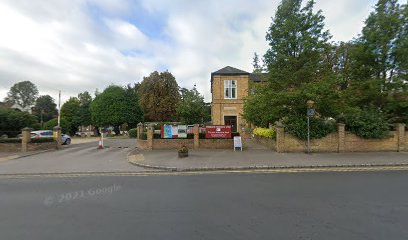
| Description | : | Christ Church United Reformed Church cemetery is now mostly a car park and most of the graves are no longer visible. However, there are several graves still in place, mostly (if not all) connected with the Wright family of Marlow Mill. Two of the Wright brothers were founder preachers of Christ Church in the nineteenth century. |
frequently asked questions (FAQ):
-
Where is Christ Church?
Christ Church is located at Oxford Road Marlow, Wycombe District ,Buckinghamshire , SL7 2NLEngland.
-
Christ Church cemetery's updated grave count on graveviews.com?
0 memorials
-
Where are the coordinates of the Christ Church?
Latitude: 51.5712799
Longitude: -0.7795249
Nearby Cemetories:
1. Sir William Borlase's Grammar School Chapel
Marlow, Wycombe District, England
Coordinate: 51.5702500, -0.7811730
2. Holy Trinity Churchyard
Marlow, Wycombe District, England
Coordinate: 51.5750000, -0.7768000
3. St. Peter Roman Catholic Churchyard
Marlow, Wycombe District, England
Coordinate: 51.5695438, -0.7723466
4. All Saints Churchyard
Marlow, Wycombe District, England
Coordinate: 51.5679730, -0.7732080
5. Marlow Cemetery
Marlow, Wycombe District, England
Coordinate: 51.5773094, -0.7761266
6. All Saints Churchyard
Bisham, Windsor and Maidenhead Royal Borough, England
Coordinate: 51.5611410, -0.7780430
7. Bisham Priory
Bisham, Windsor and Maidenhead Royal Borough, England
Coordinate: 51.5566350, -0.7796570
8. St John the Baptist Churchyard
Cookham Dean, Windsor and Maidenhead Royal Borough, England
Coordinate: 51.5581960, -0.7447210
9. St. John the Baptist Churchyard
Little Marlow, Wycombe District, England
Coordinate: 51.5826450, -0.7398600
10. St Mary the Virgin Churchyard
Hurley, Windsor and Maidenhead Royal Borough, England
Coordinate: 51.5492640, -0.8103620
11. Fern Lane Cemetery
Little Marlow, Wycombe District, England
Coordinate: 51.5887390, -0.7273880
12. Cookham Parish Cemetery
Cookham, Windsor and Maidenhead Royal Borough, England
Coordinate: 51.5485170, -0.7270770
13. St Peter and St Paul Churchyard
Medmenham, Wycombe District, England
Coordinate: 51.5533800, -0.8407110
14. St James the Less Churchyard
Stubbings, Windsor and Maidenhead Royal Borough, England
Coordinate: 51.5274840, -0.7759100
15. Holy Trinity Churchyard
Cookham, Windsor and Maidenhead Royal Borough, England
Coordinate: 51.5613910, -0.7074150
16. All Saints Cemetery
Maidenhead, Windsor and Maidenhead Royal Borough, England
Coordinate: 51.5262600, -0.7421200
17. United Reformed Church Cemetery
Bourne End, Wycombe District, England
Coordinate: 51.5769930, -0.6972670
18. Bethel Chapel Cores End-Independent
Wooburn, Wycombe District, England
Coordinate: 51.5770400, -0.6971420
19. St Nicholas Churchyard
Hedsor, Wycombe District, England
Coordinate: 51.5675780, -0.6924980
20. Wooburn & Bourne End Cemetery
Wooburn, Wycombe District, England
Coordinate: 51.5795260, -0.6919400
21. St. John the Evangelist Churchyard
Hambleden, Wycombe District, England
Coordinate: 51.6052700, -0.8514000
22. St Luke Cemetery
Maidenhead, Windsor and Maidenhead Royal Borough, England
Coordinate: 51.5265500, -0.7233700
23. Saint Mary the Virgin Churchyard
Hambleden, Wycombe District, England
Coordinate: 51.5773100, -0.8709500
24. Cliveden War Memorial Cemetery
Taplow, South Bucks District, England
Coordinate: 51.5578380, -0.6900160