
| Memorials | : | 0 |
| Location | : | Birmingham, Metropolitan Borough of Birmingham, England |
| Coordinate | : | 52.4798000, -1.9020000 |
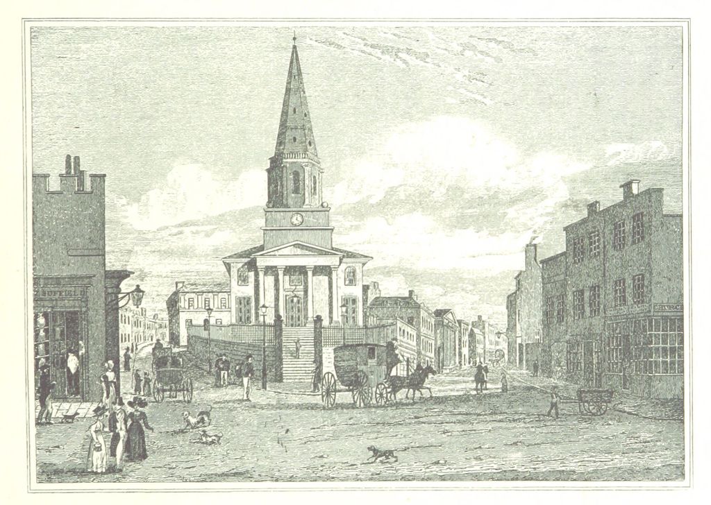
| Description | : | The church was built by public subscription. The site was donated by William Phillips Ing. The foundation stone was laid on 22 July 1805 by George Legge, 3rd Earl of Dartmouth. It was consecrated on 6 July 1813 by James Cornwallis, 4th Earl Cornwallis, the Bishop of Lichfield. The building and site were sold in 1897; the proceeds were used to build St Agatha's Church, Sparkbrook. The church was demolished in 1899. Part of the parish was given to St Barnabas' Church, Birmingham. |
frequently asked questions (FAQ):
-
Where is Christ Church Churchyard?
Christ Church Churchyard is located at Birmingham, Metropolitan Borough of Birmingham ,West Midlands ,England.
-
Christ Church Churchyard cemetery's updated grave count on graveviews.com?
0 memorials
-
Where are the coordinates of the Christ Church Churchyard?
Latitude: 52.4798000
Longitude: -1.9020000
Nearby Cemetories:
1. Birmingham Cathedral
Birmingham, Metropolitan Borough of Birmingham, England
Coordinate: 52.4812000, -1.8989060
2. Old Quaker Burial Ground
Birmingham, Metropolitan Borough of Birmingham, England
Coordinate: 52.4823770, -1.8960750
3. St. Paul's Churchyard
Birmingham, Metropolitan Borough of Birmingham, England
Coordinate: 52.4852472, -1.9057710
4. St Martin in the Bull Ring
Birmingham, Metropolitan Borough of Birmingham, England
Coordinate: 52.4770050, -1.8932950
5. Saint Marys Chapel (Defunct)
Birmingham, Metropolitan Borough of Birmingham, England
Coordinate: 52.4850600, -1.8961600
6. St Thomas Bath Row
Birmingham, Metropolitan Borough of Birmingham, England
Coordinate: 52.4731740, -1.9062371
7. Warstone Lane Cemetery
Birmingham, Metropolitan Borough of Birmingham, England
Coordinate: 52.4874340, -1.9139250
8. Key Hill Cemetery
Birmingham, Metropolitan Borough of Birmingham, England
Coordinate: 52.4908400, -1.9158600
9. St. James the Less Churchyard
Birmingham, Metropolitan Borough of Birmingham, England
Coordinate: 52.4867050, -1.8797570
10. All Saints Churchyard
Hockley, Metropolitan Borough of Birmingham, England
Coordinate: 52.4915890, -1.9218570
11. Holy Trinity Churchyard
Bordesley, Metropolitan Borough of Birmingham, England
Coordinate: 52.4706200, -1.8776200
12. St. Matthews Churchyard
Duddeston, Metropolitan Borough of Birmingham, England
Coordinate: 52.4905400, -1.8775100
13. St Bartholomew Churchyard
Edgbaston, Metropolitan Borough of Birmingham, England
Coordinate: 52.4606870, -1.9170890
14. Birmingham Prison Cemetery
Birmingham, Metropolitan Borough of Birmingham, England
Coordinate: 52.4932060, -1.9372360
15. St Josephs Churchyard
Nechells, Metropolitan Borough of Birmingham, England
Coordinate: 52.4989600, -1.8710100
16. St. Saviour Churchyard
Saltley, Metropolitan Borough of Birmingham, England
Coordinate: 52.4872100, -1.8579400
17. St Peter and St Paul Churchyard
Aston, Metropolitan Borough of Birmingham, England
Coordinate: 52.5070340, -1.8796590
18. St. Mary's Churchyard
Handsworth, Metropolitan Borough of Birmingham, England
Coordinate: 52.5106700, -1.9193690
19. St. Mary's Churchyard
Moseley, Metropolitan Borough of Birmingham, England
Coordinate: 52.4462000, -1.8866900
20. St. Mary's Churchyard
Harborne, Metropolitan Borough of Birmingham, England
Coordinate: 52.4566000, -1.9540700
21. St. Paul's Convent Cemetery
Birmingham, Metropolitan Borough of Birmingham, England
Coordinate: 52.4401580, -1.9217800
22. Sisters of Charity of St Paul the Apostle Convent
Birmingham, Metropolitan Borough of Birmingham, England
Coordinate: 52.4393400, -1.9205200
23. Smethwick Old Churchyard
Smethwick, Metropolitan Borough of Sandwell, England
Coordinate: 52.4869000, -1.9724600
24. St. Peter's Churchyard
Harborne, Metropolitan Borough of Birmingham, England
Coordinate: 52.4533600, -1.9589050