
| Memorials | : | 0 |
| Location | : | Birmingham, Metropolitan Borough of Birmingham, England |
| Coordinate | : | 52.4823770, -1.8960750 |
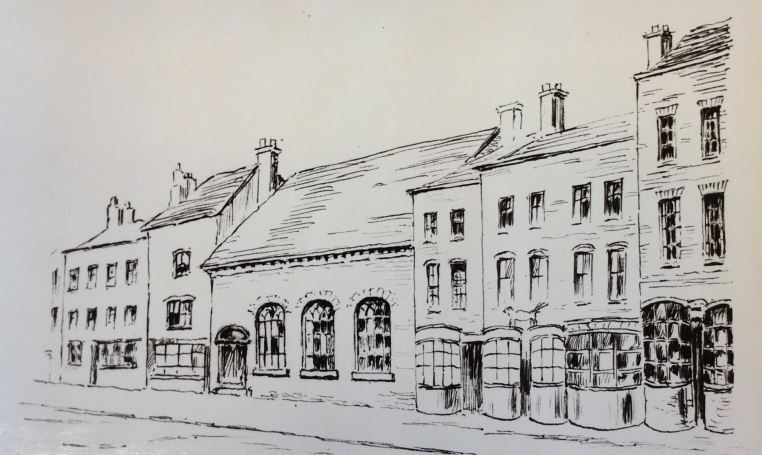
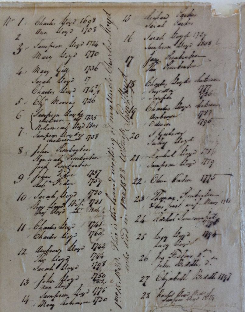
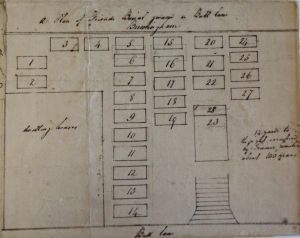
| Description | : | Founded 1682. Was situated in Bull Lane (now Bull Street), off Monmouth Street. Now part of Colmore Row. Shut and remains removed in 1850 to make way for the Great Western Railway. |
frequently asked questions (FAQ):
-
Where is Old Quaker Burial Ground?
Old Quaker Burial Ground is located at Bull Street Birmingham, Metropolitan Borough of Birmingham ,West Midlands ,England.
-
Old Quaker Burial Ground cemetery's updated grave count on graveviews.com?
0 memorials
-
Where are the coordinates of the Old Quaker Burial Ground?
Latitude: 52.4823770
Longitude: -1.8960750
Nearby Cemetories:
1. Birmingham Cathedral
Birmingham, Metropolitan Borough of Birmingham, England
Coordinate: 52.4812000, -1.8989060
2. Saint Marys Chapel (Defunct)
Birmingham, Metropolitan Borough of Birmingham, England
Coordinate: 52.4850600, -1.8961600
3. Christ Church Churchyard
Birmingham, Metropolitan Borough of Birmingham, England
Coordinate: 52.4798000, -1.9020000
4. St Martin in the Bull Ring
Birmingham, Metropolitan Borough of Birmingham, England
Coordinate: 52.4770050, -1.8932950
5. St. Paul's Churchyard
Birmingham, Metropolitan Borough of Birmingham, England
Coordinate: 52.4852472, -1.9057710
6. St. James the Less Churchyard
Birmingham, Metropolitan Borough of Birmingham, England
Coordinate: 52.4867050, -1.8797570
7. St Thomas Bath Row
Birmingham, Metropolitan Borough of Birmingham, England
Coordinate: 52.4731740, -1.9062371
8. Warstone Lane Cemetery
Birmingham, Metropolitan Borough of Birmingham, England
Coordinate: 52.4874340, -1.9139250
9. St. Matthews Churchyard
Duddeston, Metropolitan Borough of Birmingham, England
Coordinate: 52.4905400, -1.8775100
10. Key Hill Cemetery
Birmingham, Metropolitan Borough of Birmingham, England
Coordinate: 52.4908400, -1.9158600
11. Holy Trinity Churchyard
Bordesley, Metropolitan Borough of Birmingham, England
Coordinate: 52.4706200, -1.8776200
12. All Saints Churchyard
Hockley, Metropolitan Borough of Birmingham, England
Coordinate: 52.4915890, -1.9218570
13. St Josephs Churchyard
Nechells, Metropolitan Borough of Birmingham, England
Coordinate: 52.4989600, -1.8710100
14. St. Saviour Churchyard
Saltley, Metropolitan Borough of Birmingham, England
Coordinate: 52.4872100, -1.8579400
15. St Bartholomew Churchyard
Edgbaston, Metropolitan Borough of Birmingham, England
Coordinate: 52.4606870, -1.9170890
16. St Peter and St Paul Churchyard
Aston, Metropolitan Borough of Birmingham, England
Coordinate: 52.5070340, -1.8796590
17. Birmingham Prison Cemetery
Birmingham, Metropolitan Borough of Birmingham, England
Coordinate: 52.4932060, -1.9372360
18. St. Mary's Churchyard
Handsworth, Metropolitan Borough of Birmingham, England
Coordinate: 52.5106700, -1.9193690
19. St. Mary's Churchyard
Moseley, Metropolitan Borough of Birmingham, England
Coordinate: 52.4462000, -1.8866900
20. St. Margaret's Churchyard
Ward End, Metropolitan Borough of Birmingham, England
Coordinate: 52.4953100, -1.8341300
21. St. Mary's Churchyard
Harborne, Metropolitan Borough of Birmingham, England
Coordinate: 52.4566000, -1.9540700
22. St John the Evangelist Churchyard
Perry Barr, Metropolitan Borough of Birmingham, England
Coordinate: 52.5260757, -1.9005234
23. Witton Cemetery
Witton, Metropolitan Borough of Birmingham, England
Coordinate: 52.5265230, -1.8827870
24. St. Paul's Convent Cemetery
Birmingham, Metropolitan Borough of Birmingham, England
Coordinate: 52.4401580, -1.9217800