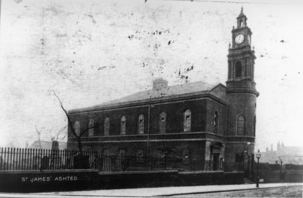
| Memorials | : | 0 |
| Location | : | Birmingham, Metropolitan Borough of Birmingham, England |
| Coordinate | : | 52.4867050, -1.8797570 |
| Description | : | The settlement takes its name from the physician John Ash, who leased the property from Sir Lester Holte and in 1771 built a grand house surrounded by fields, gardens and orchards. He never occupied the house, selling the lease to John Brooke, a Birmingham attorney. Brooke laid out streets and divided the property into parcels with the intention of bringing wealth to the area, many affluent entrepreneurs were living in Birmingham during the Industrial Revolution. In 1791, after Brooke added a cupola, Dr. Ashs house was opened as the church of St James the Less. The Ashted Barracks were erected... Read More |
frequently asked questions (FAQ):
-
Where is St. James the Less Churchyard?
St. James the Less Churchyard is located at (corner of Barrack Street and Great Brook Street). Birmingham, Metropolitan Borough of Birmingham ,West Midlands ,England.
-
St. James the Less Churchyard cemetery's updated grave count on graveviews.com?
0 memorials
-
Where are the coordinates of the St. James the Less Churchyard?
Latitude: 52.4867050
Longitude: -1.8797570
Nearby Cemetories:
1. St. Matthews Churchyard
Duddeston, Metropolitan Borough of Birmingham, England
Coordinate: 52.4905400, -1.8775100
2. Saint Marys Chapel (Defunct)
Birmingham, Metropolitan Borough of Birmingham, England
Coordinate: 52.4850600, -1.8961600
3. Old Quaker Burial Ground
Birmingham, Metropolitan Borough of Birmingham, England
Coordinate: 52.4823770, -1.8960750
4. St Martin in the Bull Ring
Birmingham, Metropolitan Borough of Birmingham, England
Coordinate: 52.4770050, -1.8932950
5. Birmingham Cathedral
Birmingham, Metropolitan Borough of Birmingham, England
Coordinate: 52.4812000, -1.8989060
6. St. Saviour Churchyard
Saltley, Metropolitan Borough of Birmingham, England
Coordinate: 52.4872100, -1.8579400
7. St Josephs Churchyard
Nechells, Metropolitan Borough of Birmingham, England
Coordinate: 52.4989600, -1.8710100
8. Christ Church Churchyard
Birmingham, Metropolitan Borough of Birmingham, England
Coordinate: 52.4798000, -1.9020000
9. St. Paul's Churchyard
Birmingham, Metropolitan Borough of Birmingham, England
Coordinate: 52.4852472, -1.9057710
10. Holy Trinity Churchyard
Bordesley, Metropolitan Borough of Birmingham, England
Coordinate: 52.4706200, -1.8776200
11. St Peter and St Paul Churchyard
Aston, Metropolitan Borough of Birmingham, England
Coordinate: 52.5070340, -1.8796590
12. Warstone Lane Cemetery
Birmingham, Metropolitan Borough of Birmingham, England
Coordinate: 52.4874340, -1.9139250
13. St Thomas Bath Row
Birmingham, Metropolitan Borough of Birmingham, England
Coordinate: 52.4731740, -1.9062371
14. Key Hill Cemetery
Birmingham, Metropolitan Borough of Birmingham, England
Coordinate: 52.4908400, -1.9158600
15. All Saints Churchyard
Hockley, Metropolitan Borough of Birmingham, England
Coordinate: 52.4915890, -1.9218570
16. St. Margaret's Churchyard
Ward End, Metropolitan Borough of Birmingham, England
Coordinate: 52.4953100, -1.8341300
17. St. Mary's Churchyard
Handsworth, Metropolitan Borough of Birmingham, England
Coordinate: 52.5106700, -1.9193690
18. St Bartholomew Churchyard
Edgbaston, Metropolitan Borough of Birmingham, England
Coordinate: 52.4606870, -1.9170890
19. Birmingham Prison Cemetery
Birmingham, Metropolitan Borough of Birmingham, England
Coordinate: 52.4932060, -1.9372360
20. Witton Cemetery
Witton, Metropolitan Borough of Birmingham, England
Coordinate: 52.5265230, -1.8827870
21. St. Mary's Churchyard
Moseley, Metropolitan Borough of Birmingham, England
Coordinate: 52.4462000, -1.8866900
22. St John the Evangelist Churchyard
Perry Barr, Metropolitan Borough of Birmingham, England
Coordinate: 52.5260757, -1.9005234
23. St. Barnabas Churchyard
Erdington, Metropolitan Borough of Birmingham, England
Coordinate: 52.5225500, -1.8392400
24. Birmingham Crematorium
Birmingham, Metropolitan Borough of Birmingham, England
Coordinate: 52.5288170, -1.9094020

