
| Memorials | : | 0 |
| Location | : | Tatham, City of Lancaster, England |
| Coordinate | : | 54.0830170, -2.5301250 |
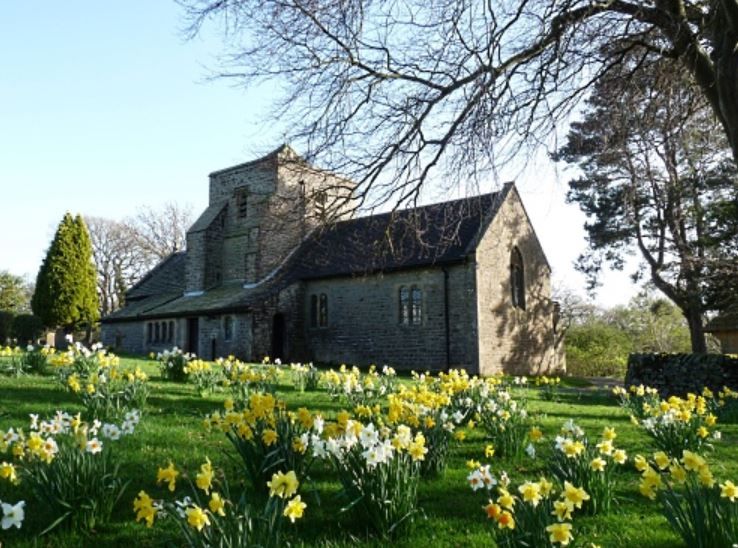
| Description | : | There has been a church in Tatham Fells on this site since at least 1577 and possibly considerably earlier. It was built as a chapel of ease to the church in Lower Tatham and seems to have lasted until 1738 when it was found to be in a ruinous state, so it was taken down and rebuilt. The present building dates from 1888-9 and cost £1,200 to construct. It was designed by the Lancaster firm of Austin and Paley. The church was originally lit by oil lamps, then from 1950 by the gaslights which are still in place. Electric lighting... Read More |
frequently asked questions (FAQ):
-
Where is Church of the Good Shepherd Churchyard?
Church of the Good Shepherd Churchyard is located at Tatham, City of Lancaster ,Lancashire ,England.
-
Church of the Good Shepherd Churchyard cemetery's updated grave count on graveviews.com?
0 memorials
-
Where are the coordinates of the Church of the Good Shepherd Churchyard?
Latitude: 54.0830170
Longitude: -2.5301250
Nearby Cemetories:
1. St Margaret Churchyard
Bentham, Craven District, England
Coordinate: 54.1146000, -2.5087300
2. St. John the Baptist Churchyard
Bentham, Craven District, England
Coordinate: 54.1180880, -2.5454540
3. Friends Burial Group
Bentham, Craven District, England
Coordinate: 54.1265450, -2.5374290
4. Holy Trinity Churchyard
Wray, City of Lancaster, England
Coordinate: 54.1022960, -2.6081510
5. St James the Less Churchyard
Tatham, City of Lancaster, England
Coordinate: 54.1190100, -2.6043200
6. All Saints Churchyard
Burton-in-Lonsdale, Craven District, England
Coordinate: 54.1437630, -2.5357130
7. St. Matthew's Churchyard
Keasden, Craven District, England
Coordinate: 54.0945680, -2.4245830
8. St. Margaret's Churchyard
Hornby, City of Lancaster, England
Coordinate: 54.1114000, -2.6362000
9. St. Wilfred Priory
Hornby, City of Lancaster, England
Coordinate: 54.1143640, -2.6405490
10. St Wilfrids Churchyard
Melling, City of Lancaster, England
Coordinate: 54.1346900, -2.6165100
11. Ingleton Cemetery
Ingleton, Craven District, England
Coordinate: 54.1495470, -2.4569780
12. St Oswald Churchyard
Thornton-in-Lonsdale, Craven District, England
Coordinate: 54.1573600, -2.4830810
13. St. Chad's Churchyard
Claughton, City of Lancaster, England
Coordinate: 54.0931310, -2.6643990
14. St Mary Churchyard
Ingleton, Craven District, England
Coordinate: 54.1540480, -2.4682980
15. St John The Baptist Churchyard
Arkholme, City of Lancaster, England
Coordinate: 54.1406220, -2.6307800
16. Clapham Parish Cemetery
Clapham, Craven District, England
Coordinate: 54.1110400, -2.3963100
17. St. John The Evangelist Churchyard
Gressingham, City of Lancaster, England
Coordinate: 54.1233910, -2.6557800
18. St John The Baptist Churchyard
Tunstall, City of Lancaster, England
Coordinate: 54.1596600, -2.5924200
19. St James Churchyard
Clapham, Craven District, England
Coordinate: 54.1202400, -2.3904970
20. St. Saviour's Church
Halton, City of Lancaster, England
Coordinate: 54.1025610, -2.6891750
21. Austwick Church Cemetery
Austwick, Craven District, England
Coordinate: 54.1081700, -2.3660600
22. St. Paul Churchyard
Caton, City of Lancaster, England
Coordinate: 54.0757840, -2.7009980
23. Saint Peter's Churchyard
Leck, City of Lancaster, England
Coordinate: 54.1836860, -2.5485980
24. St. Michael the Archangel Churchyard
Whittington, City of Lancaster, England
Coordinate: 54.1807620, -2.6148790